
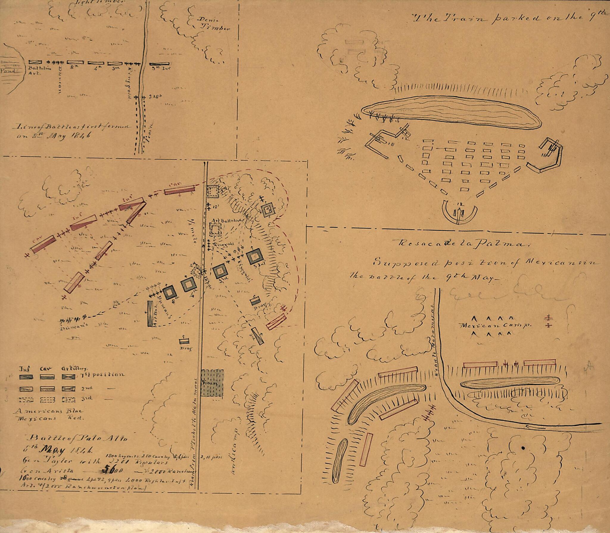
Battle of Palo Alto, 8th May 1846
- Regular price
-
$49.95 - Regular price
-
$34.95 - Sale price
-
$49.95
Buy one map, get any other map in our collection for 50% OFF! Add to cart to see discount.
Couldn't load pickup availability
About This Map
Discover the timeless beauty of our fine art quality printed reproduction of this antique map. Perfect for history enthusiasts, collectors, and interior decorators.
Restored with meticulous attention to detail by our team with over a decade of experience, this stunning reproduction captures the intricate artistry and historical significance of the original map.
Whether you're a collector or seeking a unique decor piece, this archival-quality map reproduction is a timeless addition to any space. Order now to bring history to life!
Old map of Matamoros, Mexico, Tamaulipas.Created by Charles R. Glynn in 1846.
- Relief shown by hachures.
- Shows military deployment of troops on May 8th and 9th, 1846 between the Americans under Gen. Taylor and the Mexicans under Gen. Arista.
- Pen-and-ink and watercolor.
- Accompanied by typewritten letter attributing authorship to Charles R. Glynn, New Orleans, September 1846.
- Ancillary maps: Lines of battle as first formed on 8th May 1846 -- The train parked on the 9th -- Resaca de la Palma, supposed position of Mexicans in the battle of 9th May.
- Unidentified architectural drawing of buildings on verso.
Map Subjects
Maps Manuscript
Matamoros (Tamaulipas Mexico)
Mexican War
Mexico
Palo Alto Battle Of Tex
Resaca De La Palma Battle Of Tex
Matamoros
Tamaulipas
Charles R. Glynn
1846
- For the best legibility, order your map in the original size or larger. Most maps have intricate detail and small text that is best appreciated when the print size hasn't been reduced.
- Sizes labeled "Fits a Standard Frame" will drop right into any frame that you purchase in that size. The sizes that we offer are commonly available online and at most retail stores.
- Our standard sizes are recommendations based on the aspect ratio of the original map, but still may require some added "white space" in one dimension to fit.
- Non-standard sizes will require custom framing, and we suggest taking your print to the frame shop of your choice after you receive it for the best results.
- Custom sizes are available, simply contact us for a quote.
Below is an approximation of the scale of a few standard sizes, and how they might appear in your space.

