

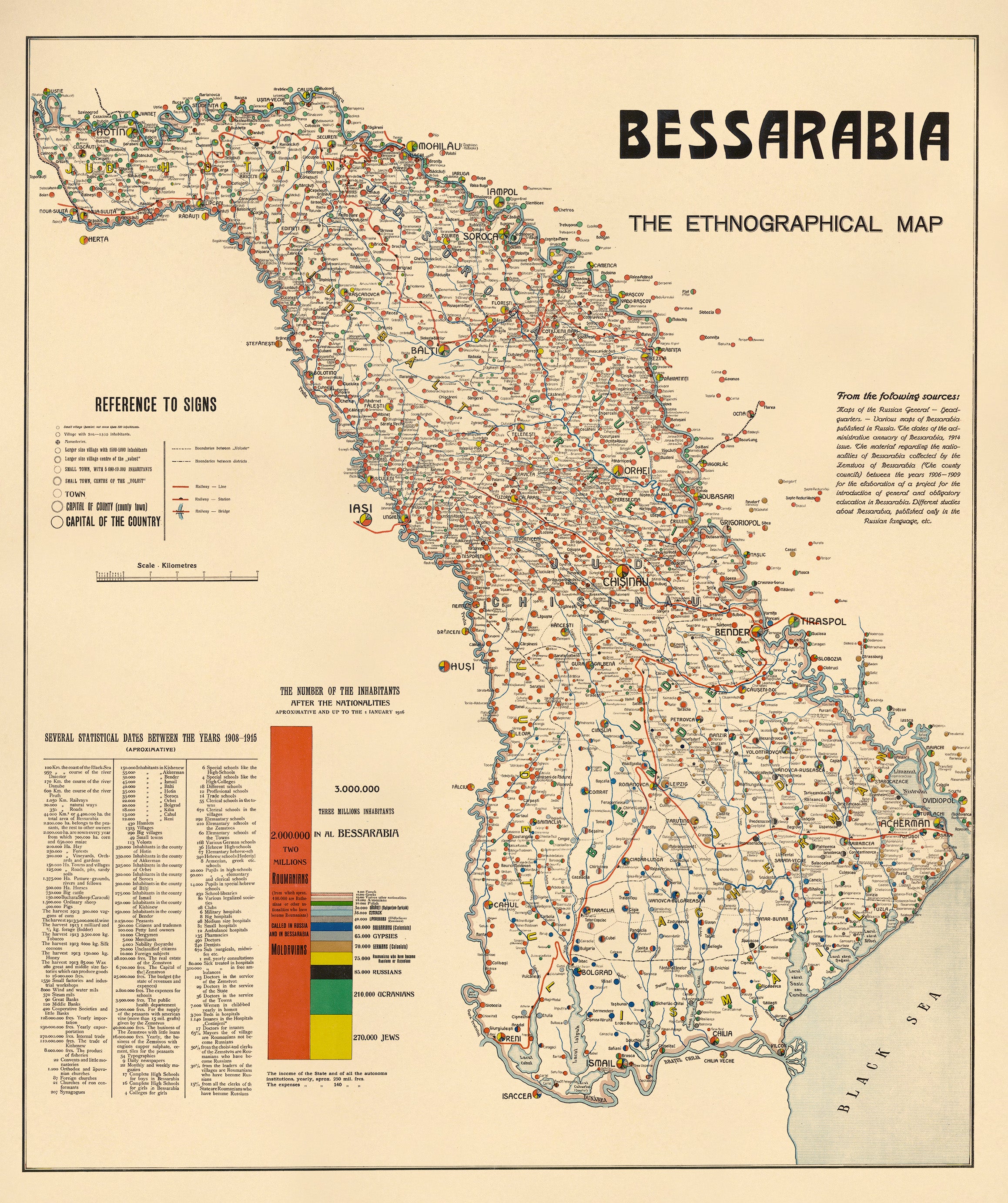
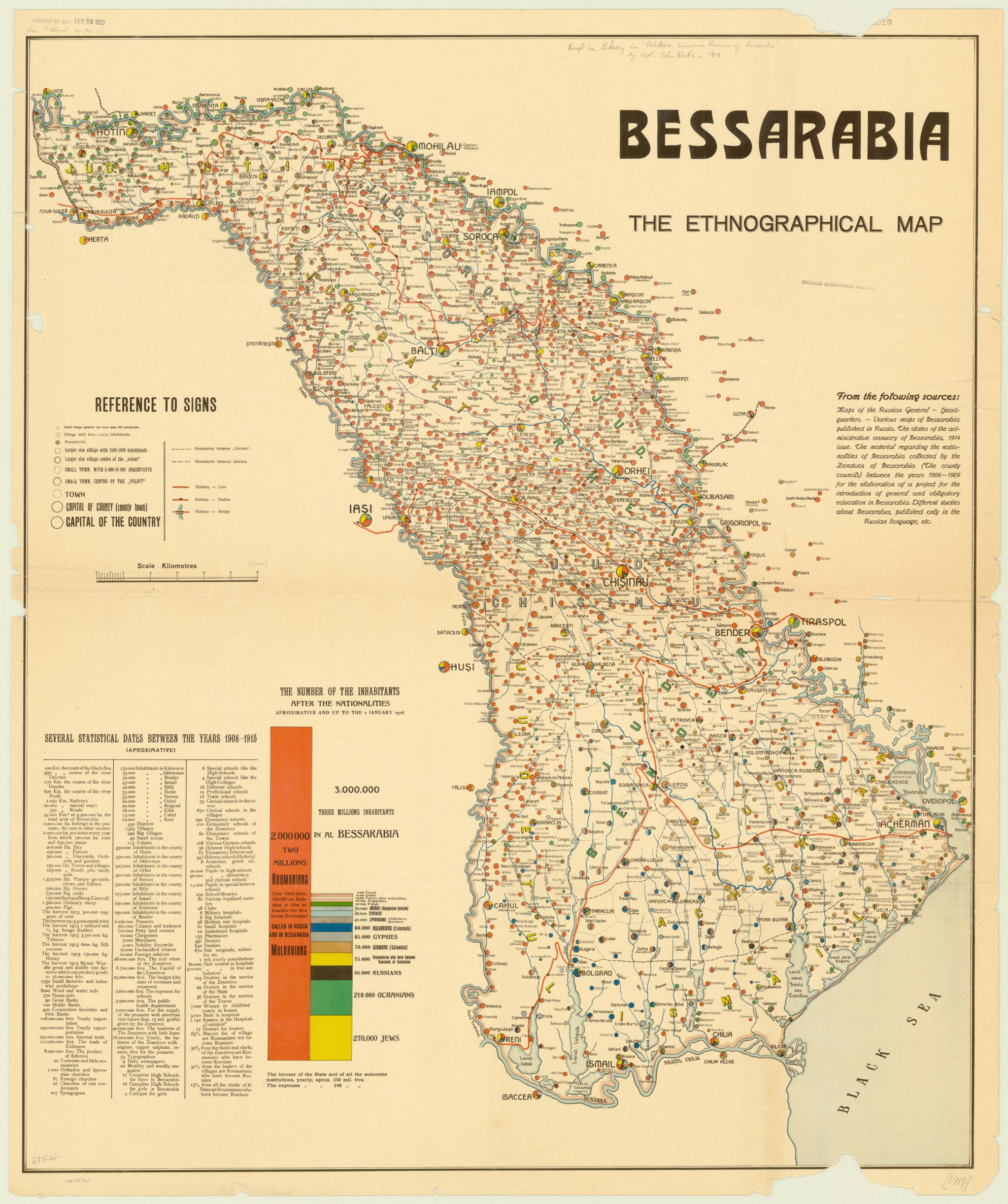
Bessarabia, the Ethnographical Map in 1919
- Regular price
-
$127.95 - Regular price
-
$122.95 - Sale price
-
$127.95
Buy one map, get any other map in our collection for 50% OFF! Add to cart to see discount.
Couldn't load pickup availability
About This Map
Discover the timeless beauty of our fine art quality printed reproduction of this antique map. Perfect for history enthusiasts, collectors, and interior decorators.
Restored with meticulous attention to detail by our team with over a decade of experience, this stunning reproduction captures the intricate artistry and historical significance of the original map.
Whether you're a collector or seeking a unique decor piece, this archival-quality map reproduction is a timeless addition to any space. Order now to bring history to life!
Old map of Moldova, Ukraine.month survey of political and economic conditions in Bessarabia (present-day Moldova) on behalf of the American Relief Administration, the organization established by the United States Congress to provide humanitarian assistance and combat mass starvation in Europe in the immediate aftermath of World War I. Kaba published his findings in a report entitled Politico-economic Review of Basarabia, issued on June 30, 1919. This map accompanied the report. It uses colored circles to show the size and ethnic composition of the populations of the towns and cities of the province. The colored bar graph to the left of the map provides a key to the circles, and gives the breakdown by ethnic group for all 3 million people in Bessarabia. The leading groups by size of population are listed as Roumanians (known as Moldavians in Russia), Jews, Ucranians [sic], Russians, "Roumaniens who have become Russians or Rutenians," Germans (Colonists), Gypsies, Bulgarians (Colonists), Lipovenians (Old Believer Russians), Cossacks, Bulgarian-Turkish, Polish, Armenians, and various other nationalities. The table on the lower left of the map provides statistics on agricultural production; religious establishments; the populations of cities, towns, and counties; occupations of the inhabitants of the province; government budgets; the press; and schools, public health, and various other topics. The map shows internal boundaries between voloste and districts, monasteries, railway lines, stations, and bridges. The scale is in kilometers.
Created by American Relief Administration, John Kaba in 1919.
- Title devised, in English, by Library staff.
- "Scale approximately 1:460,000"--Note extracted from World Digital Library.
- Original resource extent: 1 map : color ; 93 x 77 centimeters.
- Original resource at: University of Wisconsin-Milwaukee Libraries.
- Content in English.
- Description based on data extracted from World Digital Library, which may be extracted from partner institutions.
- For the best legibility, order your map in the original size or larger. Most maps have intricate detail and small text that is best appreciated when the print size hasn't been reduced.
- Sizes labeled "Fits a Standard Frame" will drop right into any frame that you purchase in that size. The sizes that we offer are commonly available online and at most retail stores.
- Our standard sizes are recommendations based on the aspect ratio of the original map, but still may require some added "white space" in one dimension to fit.
- Non-standard sizes will require custom framing, and we suggest taking your print to the frame shop of your choice after you receive it for the best results.
- Custom sizes are available, simply contact us for a quote.
Below is an approximation of the scale of a few standard sizes, and how they might appear in your space.

