
Bird's Eye View of Amsterdam, 1597. (Amsterdam Anno 1597)
- Regular price
-
$145.95 - Regular price
-
$140.95 - Sale price
-
$145.95
Buy one map, get any other map in our collection for 50% OFF! Add to cart to see discount.
Couldn't load pickup availability
About This Map
Discover the timeless beauty of our fine art quality printed reproduction of this antique map. Perfect for history enthusiasts, collectors, and interior decorators.
Restored with meticulous attention to detail by our team with over a decade of experience, this stunning reproduction captures the intricate artistry and historical significance of the original map.
Whether you're a collector or seeking a unique decor piece, this archival-quality map reproduction is a timeless addition to any space. Order now to bring history to life!
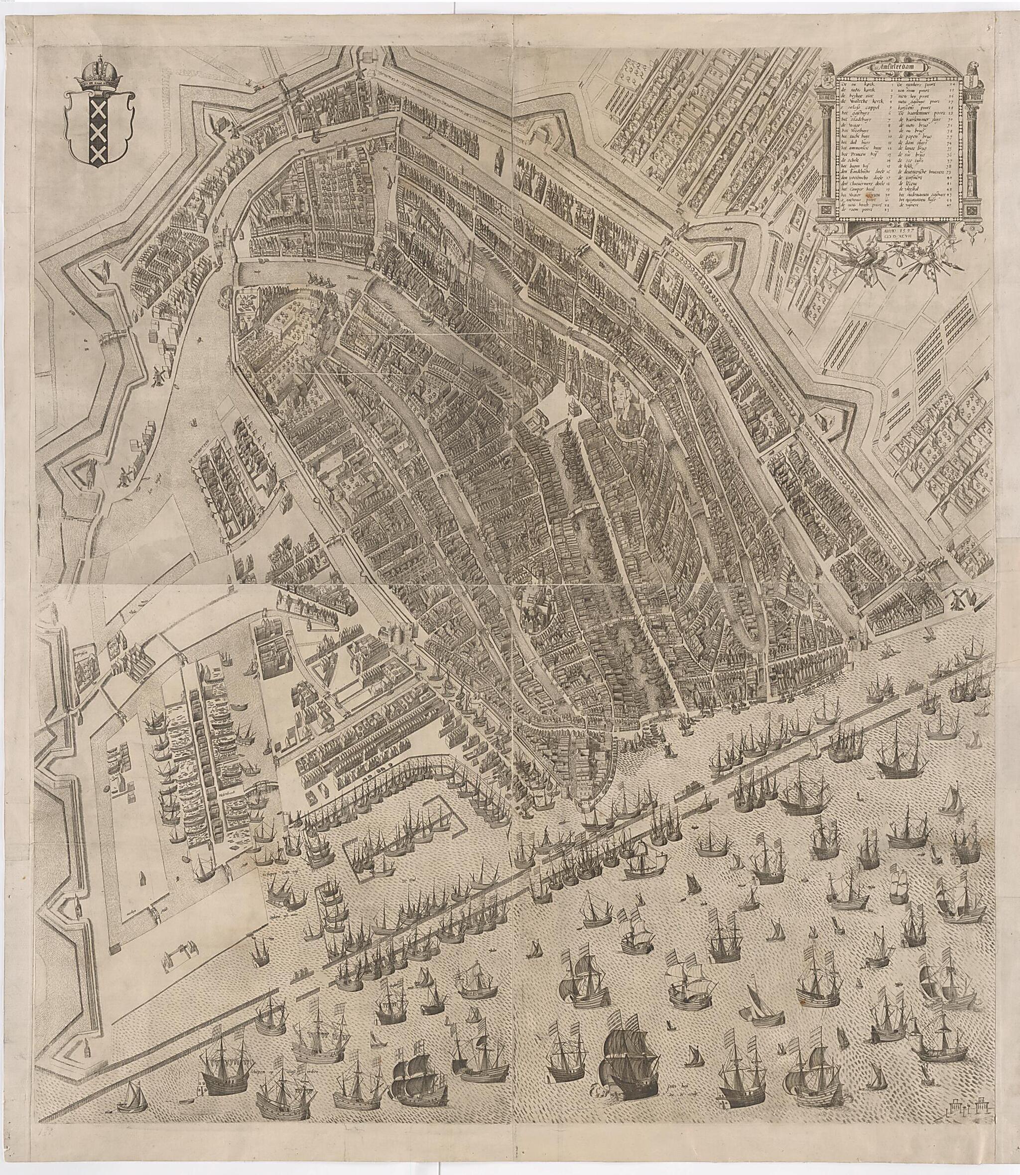
Old map of Amsterdam, Netherlands, Holland.eye view of Amsterdam in 1597 is from the collection of cityscapes and broadsheets that once belonged to the Swedish statesman Count Magnus Gabriel De la Gardie (1622-86). In the upper right is a key, in Dutch, listing important landmarks in the city, including churches, city hall, and bridges. The map is by Pieter Bast (circa 1570-1605), a Dutch cartographer and engraver, who specialized in cityscapes. The Magnus Gabriel De la Gardie Collection consists of 187 engravings from the late 1500s and early 1600s. The prints originally were bound, ordered, and assigned a number. The early provenance of the collection is uncertain. After perusing the correspondence of King Gustav II Adolf and the Dutch philologist and diplomat Johannes Rutgersius, the former national librarian of Sweden E.W. Dahlgren conjectured that the pictures were ordered by the king and purchased by Rutgersius. The collection later was incorporated into the library of Magnus Gabriel De la Gardie, then deposited in the Archive of Antiquities at the end of the 17th century, only to be transferred to the Royal Library in 1780. An exhaustive catalog of the collection was published by Isak Collijn in 1915, Magnus Gabriel de la Gardie's samling af äldre stadsvyer och historiska planscher i Kungl. Biblioteket. Dahlgren provides an account of the early provenance of the collection in his article, "Miscellanea" in Nordisk tidskrift för bok- och biblioteksväsen (1920).
Created by Pieter Bast in 1597.
- Title devised, in English, by Library staff.
- "Shelfmark: KoB DelaG 161"--Note extracted from World Digital Library.
- Original resource extent: 1 engraving ; 82 x 93 centimeters.
- Original resource at: National Library of Sweden.
- Content in Latin and Dutch.
- Description based on data extracted from World Digital Library, which may be extracted from partner institutions.
Map Subjects
Aerial Views
Amsterdam
Canals
Cities And Towns
City Walls
Netherlands
Holland
Ships
Pieter Bast
1597
- For the best legibility, order your map in the original size or larger. Most maps have intricate detail and small text that is best appreciated when the print size hasn't been reduced.
- Sizes labeled "Fits a Standard Frame" will drop right into any frame that you purchase in that size. The sizes that we offer are commonly available online and at most retail stores.
- Our standard sizes are recommendations based on the aspect ratio of the original map, but still may require some added "white space" in one dimension to fit.
- Non-standard sizes will require custom framing, and we suggest taking your print to the frame shop of your choice after you receive it for the best results.
- Custom sizes are available, simply contact us for a quote.
Below is an approximation of the scale of a few standard sizes, and how they might appear in your space.

