
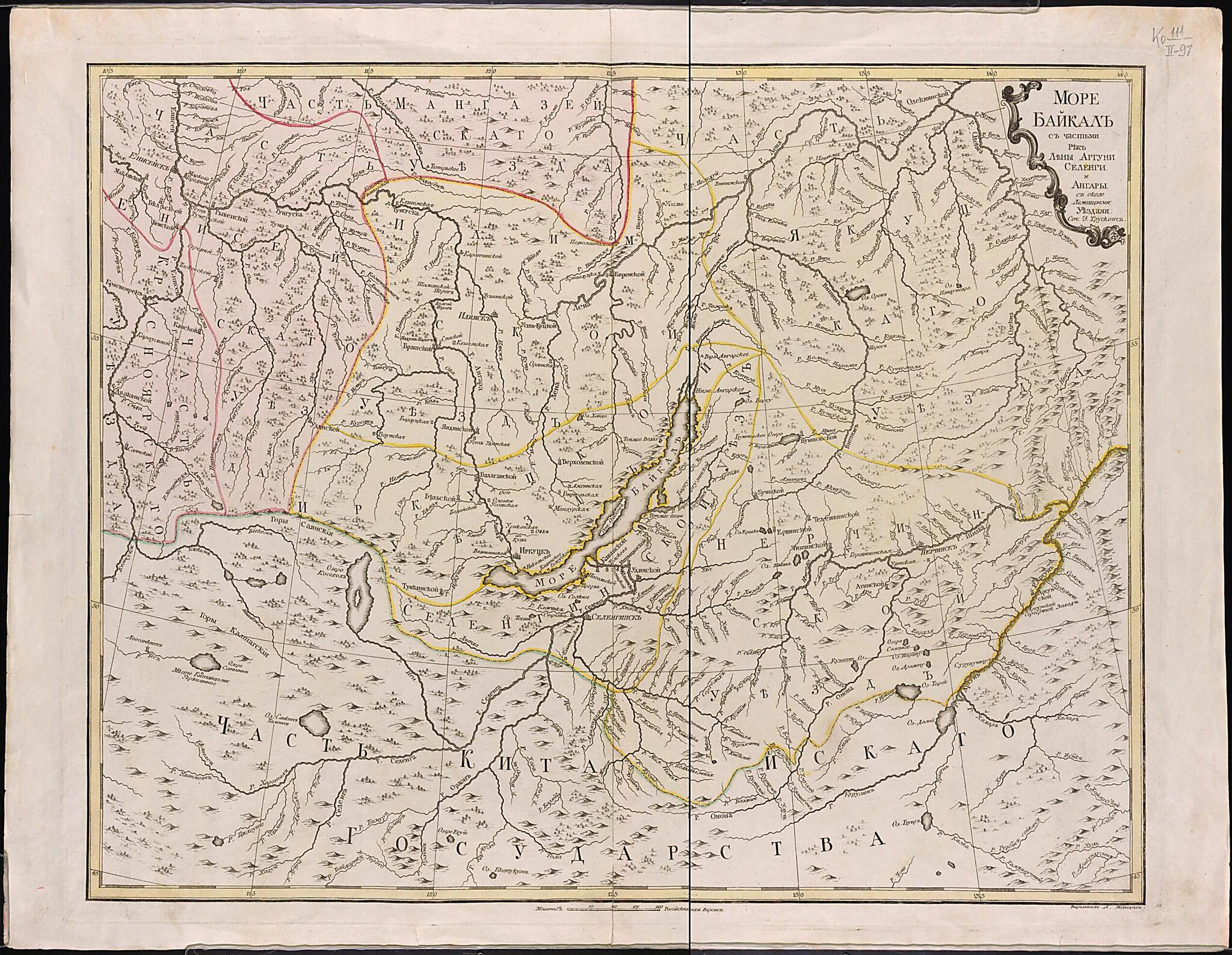
More Baĭkal S Chast'i︠u︡ Rek Leny,Arguni, Selengi I Angary S Okololezhashchimi Uezdami. (Море Байкал с частью рек Лены,Аргуни, Селенги и Ангары с окололежащими уездами.) 1772
- Regular price
-
$62.95 - Regular price
-
$57.95 - Sale price
-
$62.95
Buy one map, get any other map in our collection for 50% OFF! Add to cart to see discount.
Couldn't load pickup availability
About This Map
Discover the timeless beauty of our fine art quality printed reproduction of this antique map. Perfect for history enthusiasts, collectors, and interior decorators.
Restored with meticulous attention to detail by our team with over a decade of experience, this stunning reproduction captures the intricate artistry and historical significance of the original map.
Whether you're a collector or seeking a unique decor piece, this archival-quality map reproduction is a timeless addition to any space. Order now to bring history to life!
Old map of Buryatia, Irkutsk Oblast, Republic of, Russian Federation.Ilimsk, Irkutsk, Selenga, Yakutsk, and Nerchinsk Districts, all shown with yellow shading and delineated by yellow boundary lines. The largest regional cities and towns are indicated. Olkhon Island, the largest island in Lake Baikal, is also visible. Northern parts of Imperial China are shown at the bottom of the map and are set off from Siberia by a conjoined yellow-and-green line. Russian areas to the west, such as parts of the Krasnoyarsk and Yeniseysk Districts, are distinguished by pink shading and a pink boundary line. The map was compiled by Johann Treskot (1719-86), a cartographer of British descent, and engraved by A. Medvedev. Treskot was a talented geodesist who was affiliated with the Geographical Department of the Russian Academy of Sciences. The scale of the map is 42 kilometers per centimeter. It indicates distance in versts, a tsarist-era unit of length equal to 1.07 kilometers. An inset in the upper-right-hand corner lists Lake Baikal and the Lena, Argun, Selenga, and Angara Rivers as the main regions shown on the map and gives the name of the compiler. World Digital Library.
Created by A. Medvedev, Johann Treskot in 1772.
- Sochinil Ivan Truskot, vyrezyval A. Medvedev. Zaglavie karty dano v kartushe. Granit︠s︡y uezdov raskrasheny ot ruki. Na karte pokazany podrobno reki s pritokami, gory, rastitel'nost'. Otmecheny krupnye naselennye punkty. V ozere oboznachen krupnyĭ ostrov Ol'khon. V nizhneĭ chasti karty pokazana chast' Kitaĭskogo gosudarstva.
- Original map at: Russian State Library
- Сочинил Иван Трускот, вырезывал А. Медведев. Заглавие карты дано в картуше. Границы уездов раскрашены от руки. На карте показаны подробно реки с притоками, горы, растительность. Отмечены крупные населенные пункты. В озере обозначен крупный остров Ольхон. В нижней части карты показана часть Китайского государства.
Map Subjects
Baikal Lake (Russia)
Buryatia Republic Of
Irkutsk Oblast
Russian Federation
Siberia
Buryatia
Republic Of
A. Medvedev
Johann Treskot
1772
- For the best legibility, order your map in the original size or larger. Most maps have intricate detail and small text that is best appreciated when the print size hasn't been reduced.
- Sizes labeled "Fits a Standard Frame" will drop right into any frame that you purchase in that size. The sizes that we offer are commonly available online and at most retail stores.
- Our standard sizes are recommendations based on the aspect ratio of the original map, but still may require some added "white space" in one dimension to fit.
- Non-standard sizes will require custom framing, and we suggest taking your print to the frame shop of your choice after you receive it for the best results.
- Custom sizes are available, simply contact us for a quote.
Below is an approximation of the scale of a few standard sizes, and how they might appear in your space.

