
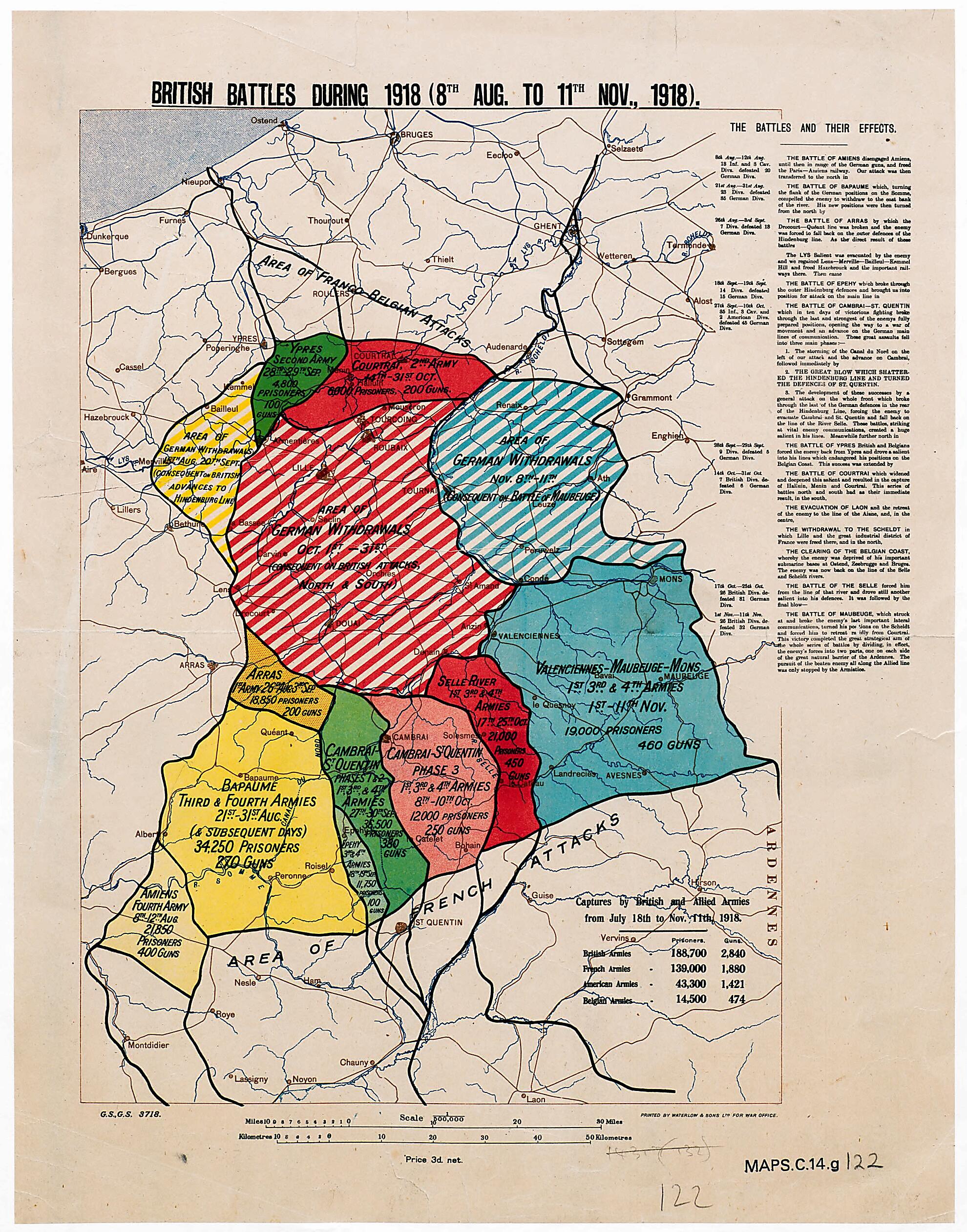
British Battles During 1918 (8th August to 11th November 1918). (British Battles During 1918 (8th Aug. to 11th Nov. 1918))
- Regular price
-
$49.95 - Regular price
-
$34.95 - Sale price
-
$49.95
Buy one map, get any other map in our collection for 50% OFF! Add to cart to see discount.
Couldn't load pickup availability
About This Map
Discover the timeless beauty of our fine art quality printed reproduction of this antique map. Perfect for history enthusiasts, collectors, and interior decorators.
Restored with meticulous attention to detail by our team with over a decade of experience, this stunning reproduction captures the intricate artistry and historical significance of the original map.
Whether you're a collector or seeking a unique decor piece, this archival-quality map reproduction is a timeless addition to any space. Order now to bring history to life!
Old map of Belgium, France.year conflict.
Created by Great Britain. War Office. General Staff. Geographical Section in 1918.
- Title devised, in English, by Library staff.
- "Scale 1:500 000"--Note extracted from World Digital Library.
- Original resource extent: 1 map : color.
- Original resource at: The British Library.
- Content in English.
- Description based on data extracted from World Digital Library, which may be extracted from partner institutions.
Map Subjects
08-08 To 1918-11-11
Battlefields
Battles
Belgium
Belgium. Army
France
France. Army
Germany. Army
Great Britain. Army
Military Maps
United States. Army
World War
Great Britain. War Office. General Staff. Geographical Section
1918
- For the best legibility, order your map in the original size or larger. Most maps have intricate detail and small text that is best appreciated when the print size hasn't been reduced.
- Sizes labeled "Fits a Standard Frame" will drop right into any frame that you purchase in that size. The sizes that we offer are commonly available online and at most retail stores.
- Our standard sizes are recommendations based on the aspect ratio of the original map, but still may require some added "white space" in one dimension to fit.
- Non-standard sizes will require custom framing, and we suggest taking your print to the frame shop of your choice after you receive it for the best results.
- Custom sizes are available, simply contact us for a quote.
Below is an approximation of the scale of a few standard sizes, and how they might appear in your space.

