
British Guiana 1908
- Regular price
-
$99.95 - Regular price
-
$94.95 - Sale price
-
$99.95
Buy one map, get any other map in our collection for 50% OFF! Add to cart to see discount.
Couldn't load pickup availability
About This Map
Discover the timeless beauty of our fine art quality printed reproduction of this antique map. Perfect for history enthusiasts, collectors, and interior decorators.
Restored with meticulous attention to detail by our team with over a decade of experience, this stunning reproduction captures the intricate artistry and historical significance of the original map.
Whether you're a collector or seeking a unique decor piece, this archival-quality map reproduction is a timeless addition to any space. Order now to bring history to life!
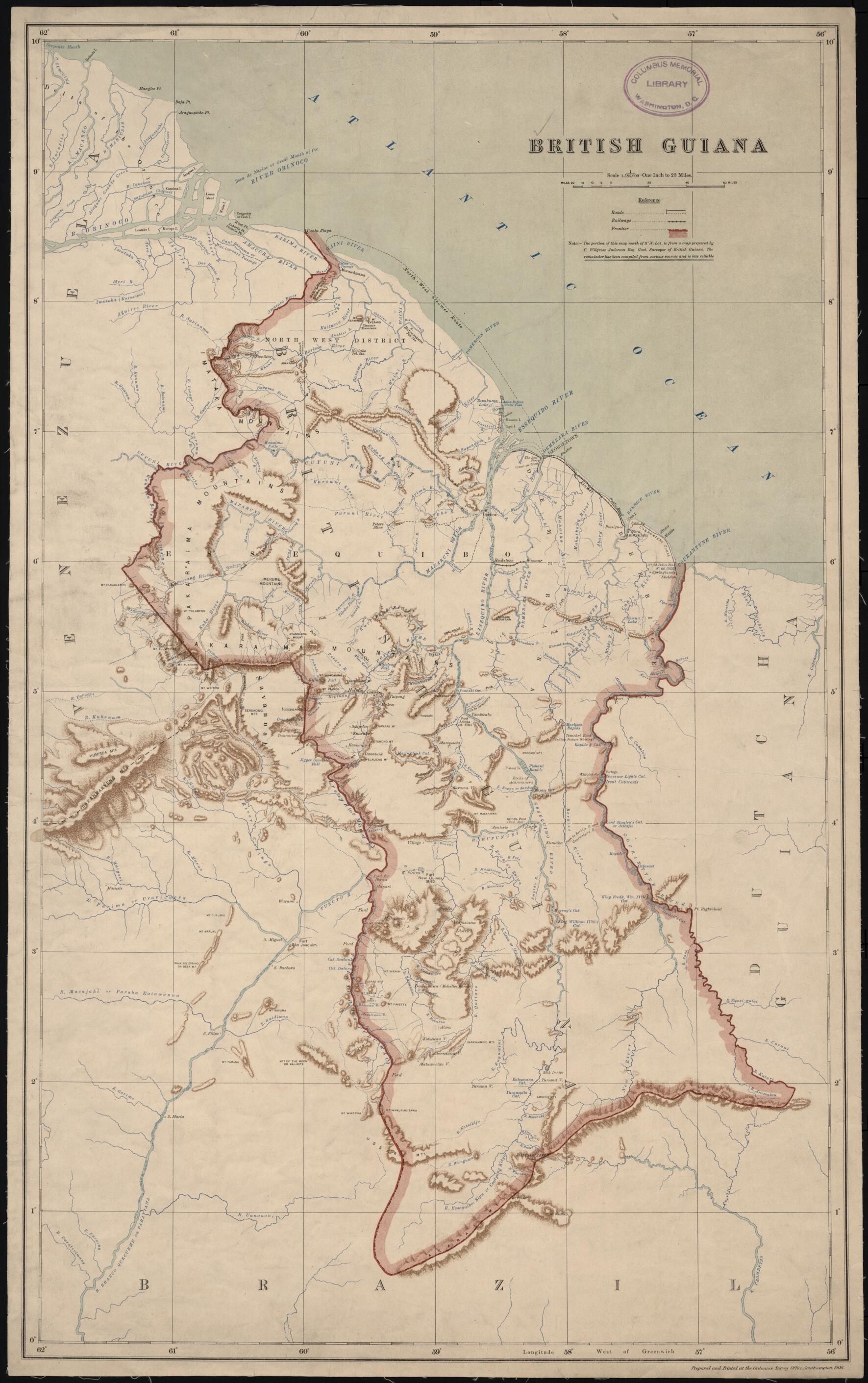
Old map of Guyana.day Guyana), one of only two British colonies on the mainland of South and Central America (the other being British Honduras). A note indicates that the portion of the map north of 5° North latitude is from a map prepared by the government surveyor of British Guiana, while the remainder of the map "has been compiled from various sources and is less reliable." Much of the territory in the south of the country was as yet unexplored. Bordered to the west by Venezuela, to the south by Brazil, and to the east by Dutch Guiana (present-day Suriname), British Guiana was the subject of a longstanding border dispute with Venezuela, in which the United States became involved and that was settled by arbitration in 1899. The map reflects the settlement, which awarded Britain most of the disputed territory but gave Venezuela undisputed control over the Orinoco River. The map shows international borders, cities and towns, railroads, posts and forts, and physical features such as rivers, cataracts, and hills and mountains.
Created by Charles Wilgress Anderson, Great Britain. Ordnance Survey in 1908.
- Title devised, in English, by Library staff.
- "Scale 1 inch to 25 miles"--Note extracted from World Digital Library.
- Original resource extent: 54 x 81 centimeters.
- Original resource at: Columbus Memorial Library, Organization of American States.
- Content in English.
- Description based on data extracted from World Digital Library, which may be extracted from partner institutions.
- For the best legibility, order your map in the original size or larger. Most maps have intricate detail and small text that is best appreciated when the print size hasn't been reduced.
- Sizes labeled "Fits a Standard Frame" will drop right into any frame that you purchase in that size. The sizes that we offer are commonly available online and at most retail stores.
- Our standard sizes are recommendations based on the aspect ratio of the original map, but still may require some added "white space" in one dimension to fit.
- Non-standard sizes will require custom framing, and we suggest taking your print to the frame shop of your choice after you receive it for the best results.
- Custom sizes are available, simply contact us for a quote.
Below is an approximation of the scale of a few standard sizes, and how they might appear in your space.

