
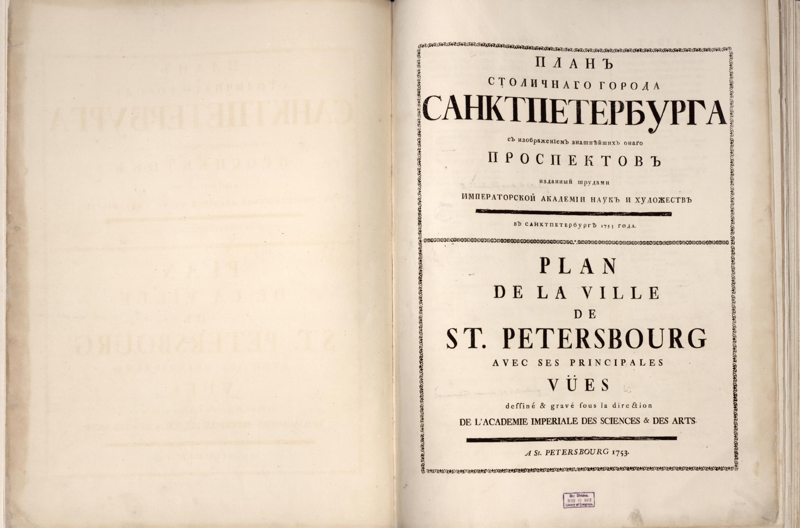
Planʺ Stolichnago Goroda Sanktpeterburga Cʺ Izobrazhenīemʺ Znatni︠e︡ĭshikhʺ Onago Prospektovʺ (Планъ столичнаго города Санктпетербурга Cъ изображеніемъ знатнѣйшихъ онаго пр...
- Regular price
-
$98.95 - Regular price
-
$93.95 - Sale price
-
$98.95
Shipping calculated at checkout.
Buy one map, get any other map in our collection for 50% OFF! Add to cart to see discount.
Couldn't load pickup availability
About This Map
Old map of Moscow, Russia, Saint Petersburg, St. Petersburg.
Created by Imperatorskai︠a︡ Akademīi︠a︡ Naukʺ I Khudozhestvʺ (Russia), Mikhail Ivanovich Makhaev, Ivan Fedorovich Michurin, Ivanʺ Aleksi︠e︡evich Sokolovʺ, Johann Treskot, Giuseppe Valeriani in 1753.
Created by Imperatorskai︠a︡ Akademīi︠a︡ Naukʺ I Khudozhestvʺ (Russia), Mikhail Ivanovich Makhaev, Ivan Fedorovich Michurin, Ivanʺ Aleksi︠e︡evich Sokolovʺ, Johann Treskot, Giuseppe Valeriani in 1753.
- "Planʺ Imperatorskago stolichnago goroda Moskvy, sochinennoĭ podʺ smotrenīemʺ arkhitektora Ivana Michurina vʺ 1739 godu," map at end. [Plan/map of the Imperial capital city of Moscow, prepared under the supervision of the architect Ivan Michurin in 1739.]
- List of buildings, etc. in Russian, romanized Russian, and French; list of streets in Russian and romanized Russian; legends on St. Petersburg map (1737) in Russian and German, on Moscow map in Russian.
- Most of the plates are signed: "Podsmotr. g. Valerīiani, snimalʺ podmasterʹi︠a︡ Mikhaĭla Makhaevʺ." Engraved by various engravers under supervision of Ivan Sokolov.
- English translation of French map captions: 1. Map of St. Petersburg from 1737 -- 2. View of the Neva towards the East between the shipyards and the 13th line of the Wasily section -- 3. View of the banks of the Neva showing the river between the Admiralty and the buildings of the Academy of Sciences -- 4. View of the banks of the Neva downriver between the Winter Palace and the buildings of the Academy of Sciences -- 5. View of the Neva towards the West between the Church of St. Isaac and the buildings of the Cadet Corps -- 6. View of the Fontancka River towards the south between the grotto and the court's storehouses -- 7. View of the Admiralty and its surroundings looking west from the triumphal arch --
- 8. View of a part of the town of St. Petersburg looking east from the triumphal arch -- 9. View of the Bourse and the commodities market while ascending from the little Neva -- 10. View of the buildings of the Imperial Colleges and a part of the commodities market toward the east -- 11. View of the New Palace from the triumphal arch of Anitschki toward the east with a part of the town and Nevsky Prospect close to the shore of the Fontanka -- 12. View of the Summer Palace from the north shore -- 13. View of the Old Winter Palace and the canal that joins the Moika and the Neva -- 14. View of Kamennoy Island on the little Newka near the St. Petersburg residence of the Countess Bestoucheff Rumin -- 15. Map of Moscow from 1739.
- Accompanied by Supplement: Stolichnoĭ gorodʹ. S. Peterburgʺ. Chertilʺ Ī. Truskotʺ. Podsmotr. Iv. Sokolova grid. khudozhniki obshche. [Vʹ Sanktpeterburgi︠e︡, 1753]. Map 135 x 100 cm. folded to 75 x 52 cm. (in portfolio). Scale not given. Issued in 9 sheets, mounted on muslin to fold. Call number: G2114.L4 A3 1753 Suppl.
- Includes index.
- Eighteenth century Russian publications in the Library of Congress (Fessenko), 11*
- "Планъ Императорскаго столичнаго города Москвы, сочиненной подъ смотреніемъ архитектора Ивана Мичурина въ 1739 году," map at end. [Plan/map of the Imperial capital city of Moscow, prepared under the supervision of the architect Ivan Michurin in 1739.]
- Most of the plates are signed: "Подсмотр. г. Валеріиани, снималъ подмастерья Михайла Махаевъ." Engraved by various engravers under supervision of Иван Соколов.
- Accompanied by Supplement: Столичной городь. С. Петербургъ. Чертилъ І. Трускотъ. Подсмотр. Ив. Соколова грид. художники обще. [Вь Санктпетербургѣ, 1753]. Map 135 x 100 cm. folded to 75 x 52 cm. (in portfolio). Scale not given. Issued in 9 sheets, mounted on muslin to fold. Call number: G2114.L4 A3 1753 Suppl.
Map Sizing Information
- For the best legibility, order your map in the original size or larger. Most maps have intricate detail and small text that is best appreciated when the print size hasn't been reduced.
- Sizes labeled "Fits a Standard Frame" will drop right into any frame that you purchase in that size. The sizes that we offer are commonly available online and at most retail stores.
- Our standard sizes are recommendations based on the aspect ratio of the original map, but still may require some added "white space" in one dimension to fit.
- Non-standard sizes will require custom framing, and we suggest taking your print to the frame shop of your choice after you receive it for the best results.
- Custom sizes are available, simply contact us for a quote.
Below is an approximation of the scale of a few standard sizes, and how they might appear in your space.
