
Carolina Septentrionale Et Meridionale En 4 Feuilles, Traduite De L'Anglois 1777
- Regular price
-
$210.95 - Regular price
-
$205.95 - Sale price
-
$210.95
Buy one map, get any other map in our collection for 50% OFF! Add to cart to see discount.
Couldn't load pickup availability
About This Map
Discover the timeless beauty of our fine art quality printed reproduction of this antique map. Perfect for history enthusiasts, collectors, and interior decorators.
Restored with meticulous attention to detail by our team with over a decade of experience, this stunning reproduction captures the intricate artistry and historical significance of the original map.
Whether you're a collector or seeking a unique decor piece, this archival-quality map reproduction is a timeless addition to any space. Order now to bring history to life!
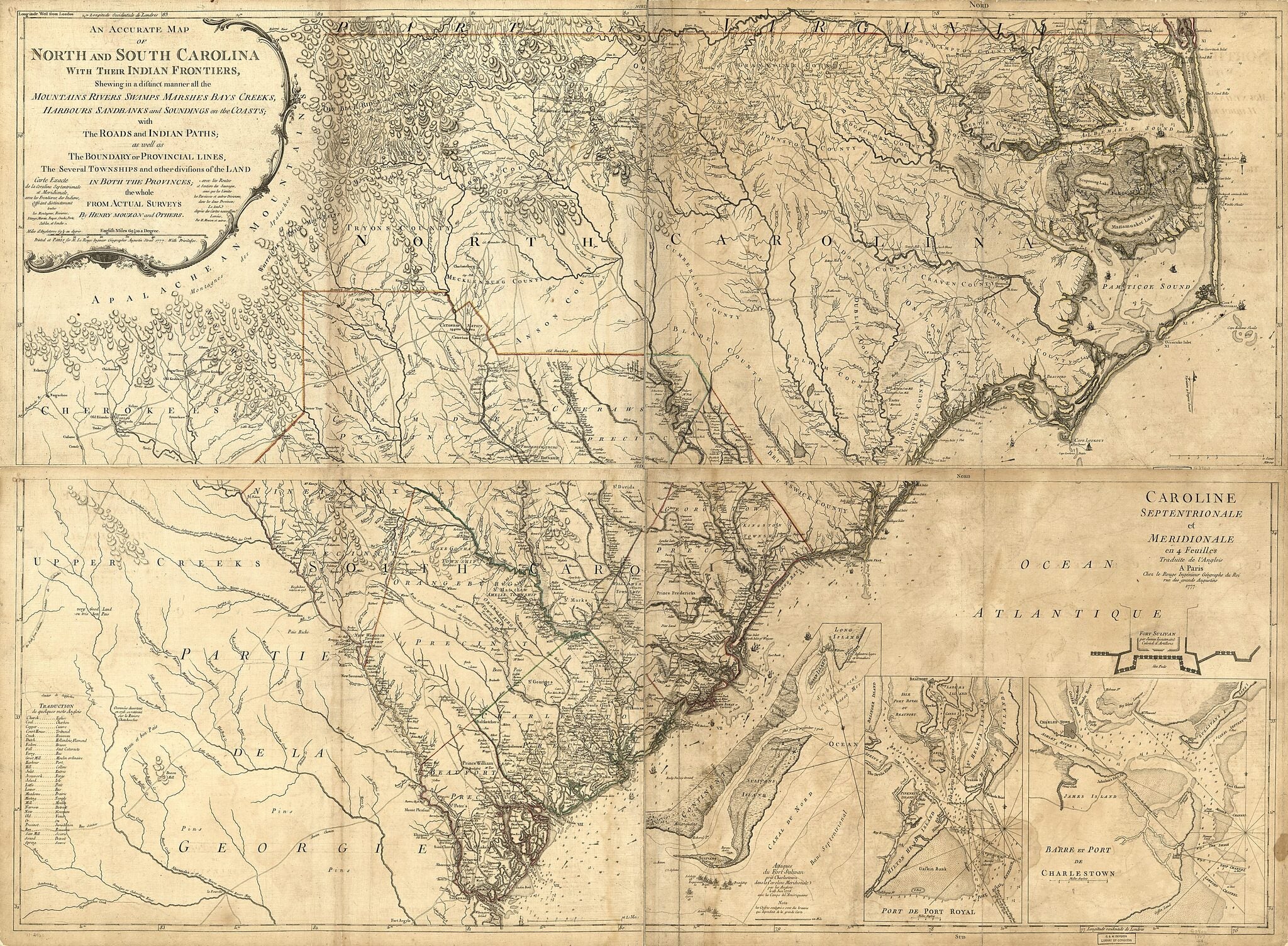
Old map of Charleston, Charleston Harbor, Fort Moultrie, North Carolina, Port Royal, South Carolina, United States.Created by Louis, Henry Mouzon in 1777.
- Scale ca. 1:560,000.
- Alternate title: An accurate map of North and South Carolina, with their Indian frontiers, shewing in a distinct manner all the mountains, rivers, swamps, marshes, bays, creeks, harbours, sandbanks, and soundings on the coast ... by Henry Mouzon and others. Carte exacte de la Coraline septentrionale et meridionale ...
- Hand colored.
- Relief shown by hachures. Depths shown by soundings.
- Shows names of land owners, precinct and township boundaries in South Carolina, and 1772 boundary line between North and South Carolina.
- Insets: Attaques du Fort Sulivan pres Charlestown dans la Caroline méridionale par les Anglois le 28. juin 1776, avec les camps des Ameriquains.--Port de Port Royal.--Brace et port de Charlestown.--Fort Sulivan, par James, lieutenant colonel d'artillerie.
Map Subjects
Administrative And Political Divisions
Charleston
Charleston Harbor (S.C.)
Early Works To 1800
Fort Moultrie
Fort Moultrie Battle Of S.C.
Harbors
North Carolina
Port Royal
South Carolina
United States
Charleston Harbor
Louis
Henry Mouzon
1777
- For the best legibility, order your map in the original size or larger. Most maps have intricate detail and small text that is best appreciated when the print size hasn't been reduced.
- Sizes labeled "Fits a Standard Frame" will drop right into any frame that you purchase in that size. The sizes that we offer are commonly available online and at most retail stores.
- Our standard sizes are recommendations based on the aspect ratio of the original map, but still may require some added "white space" in one dimension to fit.
- Non-standard sizes will require custom framing, and we suggest taking your print to the frame shop of your choice after you receive it for the best results.
- Custom sizes are available, simply contact us for a quote.
Below is an approximation of the scale of a few standard sizes, and how they might appear in your space.

