
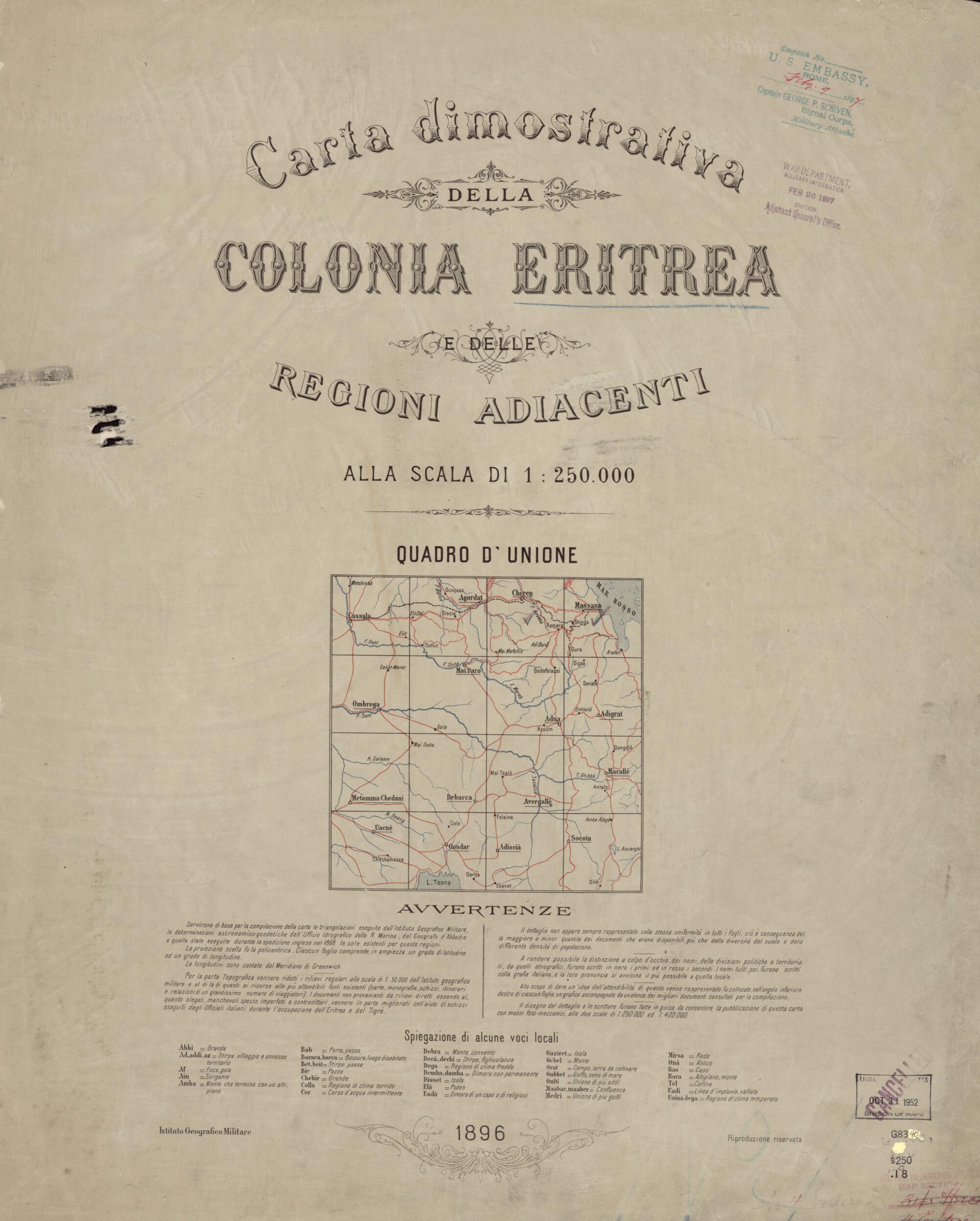
Carta Dimostrativa Della Colonia Eritrea E Delle Regioni Adiacenti Alla Scala Di 1:250,000 in 1896
- Regular price
-
$98.95 - Regular price
-
$93.95 - Sale price
-
$98.95
Buy one map, get any other map in our collection for 50% OFF! Add to cart to see discount.
Couldn't load pickup availability
About This Map
Discover the timeless beauty of our fine art quality printed reproduction of this antique map. Perfect for history enthusiasts, collectors, and interior decorators.
Restored with meticulous attention to detail by our team with over a decade of experience, this stunning reproduction captures the intricate artistry and historical significance of the original map.
Whether you're a collector or seeking a unique decor piece, this archival-quality map reproduction is a timeless addition to any space. Order now to bring history to life!
Old map of Africa, Eritrea, Ethiopia, Italy, Sudan.day Eritrea in 1885. The Treaty of Wichale (Uccialli) of 1889, concluded with Emperor Menelik of Ethiopia, gave Italy sovereignty over the territory that the Italians called Eritrea, a name derived from Mare Erythraeum, the Roman designation for the Red Sea. The Italian government tasked the Florence-based Institute for Military Geography to produce detailed and precise topographical maps of the new colony. The institute published this map in 1896. The map consists of 16 sheets and covers all of present-day Eritrea, as well as part of eastern Sudan and part of northern Ethiopia. The Italian cartographic exploration of Eritrea reached its peak in 1909, by which time most of the on-the-ground topographic and geodetic activities were concluded. Various Italian government entities, including the Ministry of the Colonies and the Ministry of Foreign Affairs, continued to publish more detailed maps of Eritrea and adjacent countries throughout the early decades of the century." World Digital Library.
Created by Istituto Geografico Militare (Italy) in 1896.
- Additionally stamped in ink at lower right of title sheet: Oct 31 1952 Division of Maps [then in blue ink] cancelled.
- Additionally stamped in red ink at lower right of title sheet: Military Information Division, Map Section.
- Also shows part of eastern Sudan and part of northern Ethiopia.
- Also stamped in blue ink at upper right of title sheet: War Department, Military Information Feb 26 1897 Divison Adjutant General's Office.
- Annotations in blue pencil on verso of maps.
- Each map includes diagram indicating sources of compilation.
- Geographic coverage complete in 16 sheets.
- Includes index map, text, and glossary on title sheet.
- Relief shown by hachures and spot heights. Depths shown by soundings.
- Sheets mounted on cloth.
- Title from title sheet.
- For the best legibility, order your map in the original size or larger. Most maps have intricate detail and small text that is best appreciated when the print size hasn't been reduced.
- Sizes labeled "Fits a Standard Frame" will drop right into any frame that you purchase in that size. The sizes that we offer are commonly available online and at most retail stores.
- Our standard sizes are recommendations based on the aspect ratio of the original map, but still may require some added "white space" in one dimension to fit.
- Non-standard sizes will require custom framing, and we suggest taking your print to the frame shop of your choice after you receive it for the best results.
- Custom sizes are available, simply contact us for a quote.
Below is an approximation of the scale of a few standard sizes, and how they might appear in your space.

