
A Hydrographical and Chorographical Chart of the Philippine Islands. (Carta Hydrographica Y Chorographica De Las Yslas Filipinas Dedicada Al Rey Nuestro Señor Por El Mariscal D. Campo D. Fernando Valdes Tamon Cavallo Del Orden De Santiago De Govor. Y...
- Regular price
-
$211.95 - Regular price
-
$206.95 - Sale price
-
$211.95
Buy one map, get any other map in our collection for 50% OFF! Add to cart to see discount.
Couldn't load pickup availability
About This Map
Discover the timeless beauty of our fine art quality printed reproduction of this antique map. Perfect for history enthusiasts, collectors, and interior decorators.
Restored with meticulous attention to detail by our team with over a decade of experience, this stunning reproduction captures the intricate artistry and historical significance of the original map.
Whether you're a collector or seeking a unique decor piece, this archival-quality map reproduction is a timeless addition to any space. Order now to bring history to life!
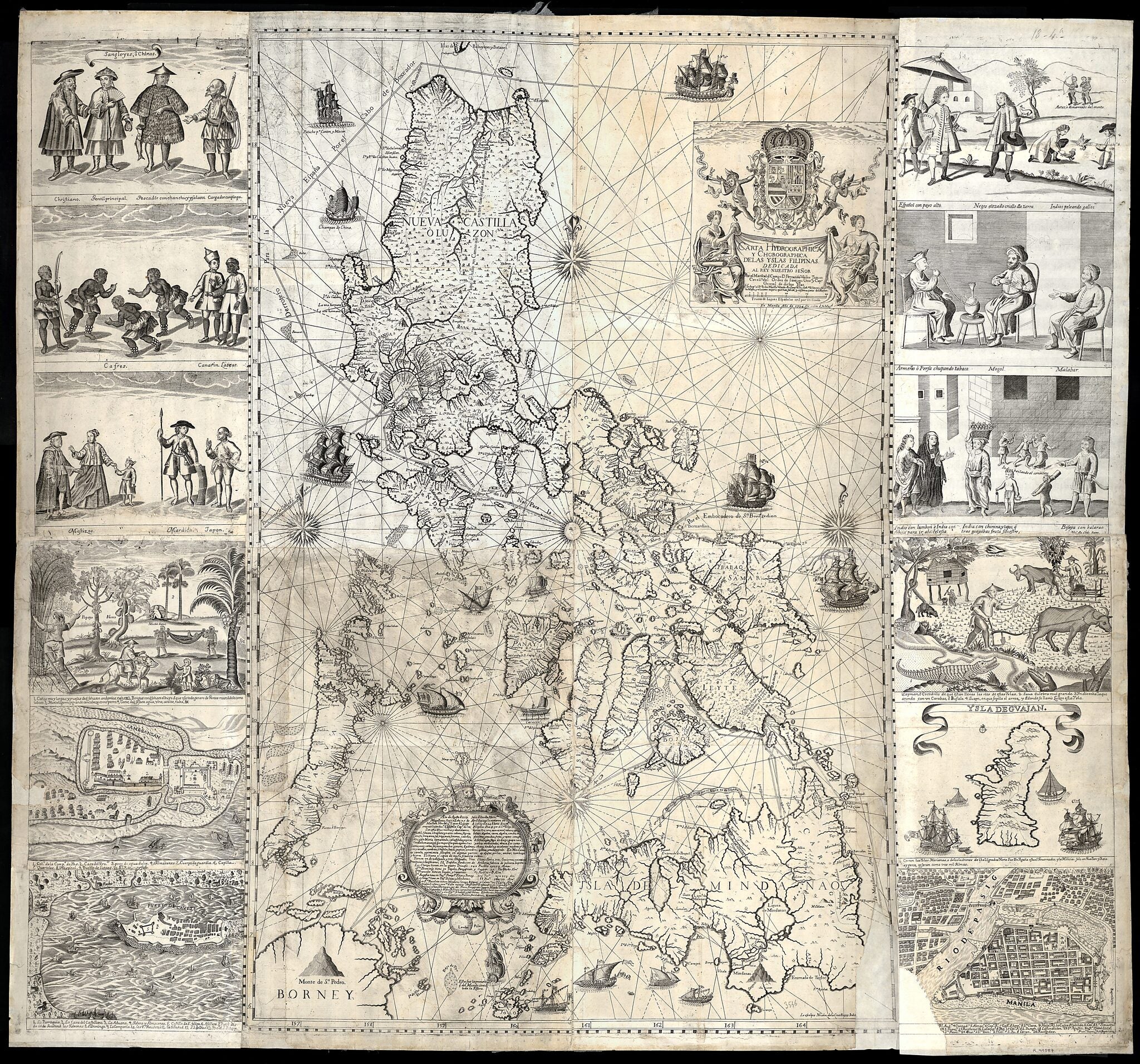
Old map of Guam, Philippines, United States of America.-1753) and published in Manila in 1734, is the first and most important scientific map of the Philippines. The Philippines were at that time a vital part of the Spanish Empire, and the map shows the maritime routes from Manila to Spain and to New Spain (Mexico and other Spanish territory in the New World), with captions. In the upper margin stands a great cartouche with the title of the map, crowned by the Spanish royal coat of arms flanked each side by an angel with a trumpet, from which an inscription unfurls. The map is not only of great interest from the geographic point of view, but also as an ethnographic document. It is flanked by twelve engravings, six on each side, eight of which depict different ethnic groups living in the archipelago and four of which are cartographic descriptions of particular cities or islands. According to the labels, the engravings on the left show: Sangleyes (Chinese Philippinos) or Chinese; Kaffirs (a derogatory term for non-Muslims), a Camarin (from the Manila area), and a Lascar (from the Indian subcontinent, a British Raj term); mestizos, a Mardica (of Portuguese extraction), and a Japanese; and two local maps--one of Samboagan (a city on Mindanao), and the other of the port of Cavite. On the right side are: various people in typical dress; three men seated, an Armenian, a Mughal, and a Malabar (from an Indian textile city); an urban scene with various peoples; a rural scene with representations of domestic and wild animals; a map of the island of Guajan (meaning Guam); and a map of Manila.
Created by Nicolás De La Cruz Bagay, Pedro Murillo Velarde in 1734.
- Title devised, in English, by Library staff.
- "Scale ca. 1:1.400.000. 20 Spanish leagues to 17 1/2 degrees = 8.8 centimeters"--Note extracted from World Digital Library.
- Original resource extent: 1 map ; 112 x 120 centimeters.
- Original resource at: National Library of Spain.
- Content in Spanish.
- Description based on data extracted from World Digital Library, which may be extracted from partner institutions.
Map Subjects
Ethnic Groups
Guam
Nautical Charts
Philippines
United States Of America
Nicolás De La Cruz Bagay
Pedro Murillo Velarde
1734
- For the best legibility, order your map in the original size or larger. Most maps have intricate detail and small text that is best appreciated when the print size hasn't been reduced.
- Sizes labeled "Fits a Standard Frame" will drop right into any frame that you purchase in that size. The sizes that we offer are commonly available online and at most retail stores.
- Our standard sizes are recommendations based on the aspect ratio of the original map, but still may require some added "white space" in one dimension to fit.
- Non-standard sizes will require custom framing, and we suggest taking your print to the frame shop of your choice after you receive it for the best results.
- Custom sizes are available, simply contact us for a quote.
Below is an approximation of the scale of a few standard sizes, and how they might appear in your space.

