
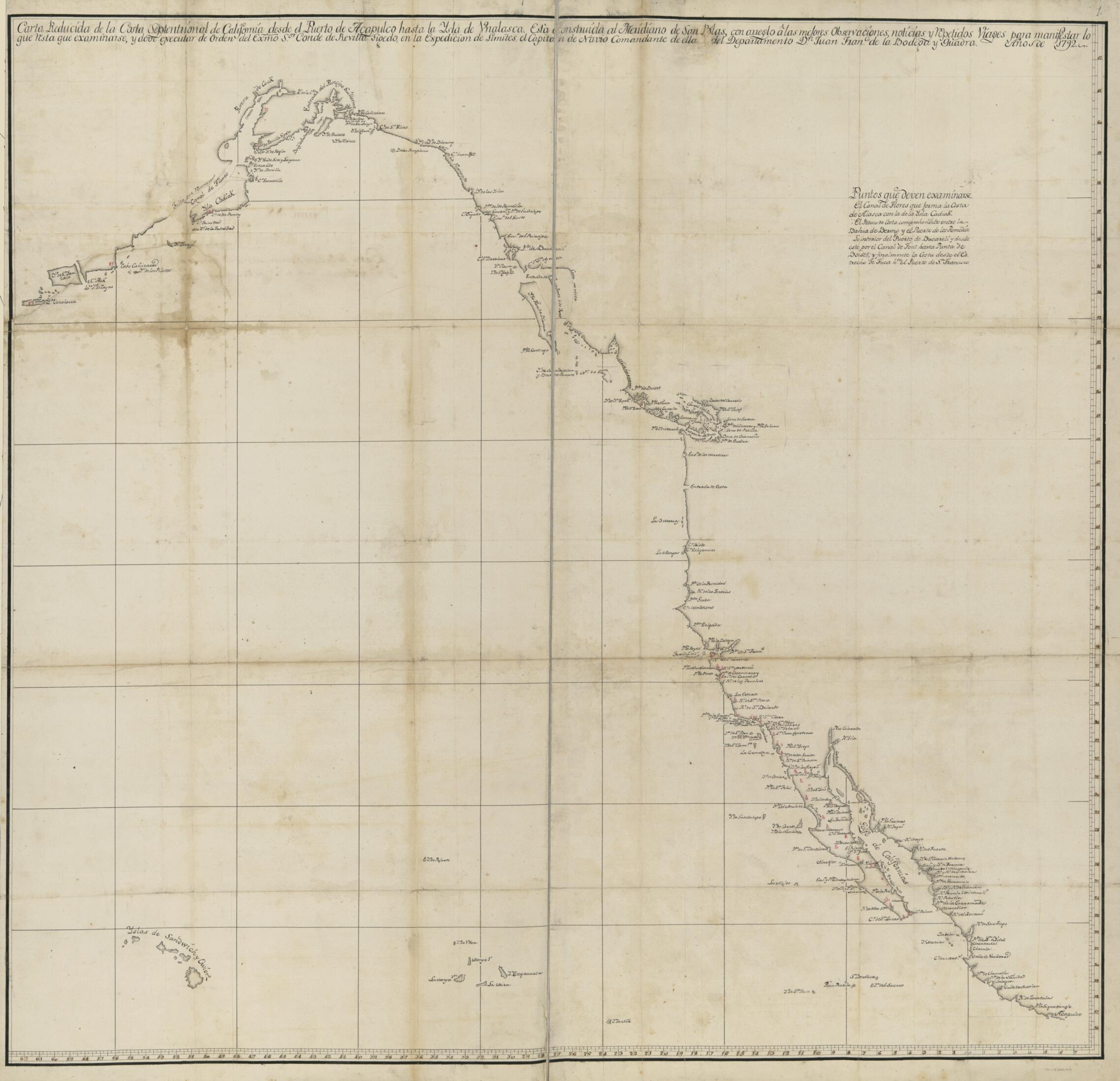
Cartas Esfericas Y Planos De Los Puertos Situados Sobre Las Costas Septentrionales De Las Californias è Yslas Adyacentes, Descubiertos Por Los Españoles 1799
- Regular price
-
$143.95 - Regular price
-
$138.95 - Sale price
-
$143.95
Buy one map, get any other map in our collection for 50% OFF! Add to cart to see discount.
Couldn't load pickup availability
About This Map
Discover the timeless beauty of our fine art quality printed reproduction of this antique map. Perfect for history enthusiasts, collectors, and interior decorators.
Restored with meticulous attention to detail by our team with over a decade of experience, this stunning reproduction captures the intricate artistry and historical significance of the original map.
Whether you're a collector or seeking a unique decor piece, this archival-quality map reproduction is a timeless addition to any space. Order now to bring history to life!
Old nautical chart / early map / manuscript map of North America, Pacific Coast.- Covers Pacific Coast extending from Mexico to Alaska.
- Relief shown by contours and hachures.
- Title and date in pencil on verso of all sheets.
- Pen-and-ink, watercolor, and pencil and mounted on cloth.
- Original format described in the Luso-Hispanic World in Maps as an atlas with index entitled,"Yndice de las Cartas, y Planos contenidos en este Libro" now missing.
- Sheet 14 entitled, "Plano del archipielago de Clayocuat situada su boca mas O. llamado Puerto de Sn. Rafael por los 49°20' de latd. N. y en la longd. de 20°55' y la mas E. nombrada de Clayocuat por los 49°7' de la misma especie y 20°22' al O. del meridiano de Sn. Blas [?]conocidas sus bocas y descubiertos todos sus brazos e islas interiores por el Thente. de Navio de la Rl. Armada Dn. Francisco de Eliza Comandte. del Paguebot de S.M. nombrado San Carlos y Goleta Sta. Saturnina (alias la Orcasitas) en este presente año de 1791" listed in Luso-Hispanic World in Maps as title of atlas.
- Includes text on some sheets.
- For the best legibility, order your map in the original size or larger. Most maps have intricate detail and small text that is best appreciated when the print size hasn't been reduced.
- Sizes labeled "Fits a Standard Frame" will drop right into any frame that you purchase in that size. The sizes that we offer are commonly available online and at most retail stores.
- Our standard sizes are recommendations based on the aspect ratio of the original map, but still may require some added "white space" in one dimension to fit.
- Non-standard sizes will require custom framing, and we suggest taking your print to the frame shop of your choice after you receive it for the best results.
- Custom sizes are available, simply contact us for a quote.
Below is an approximation of the scale of a few standard sizes, and how they might appear in your space.

