
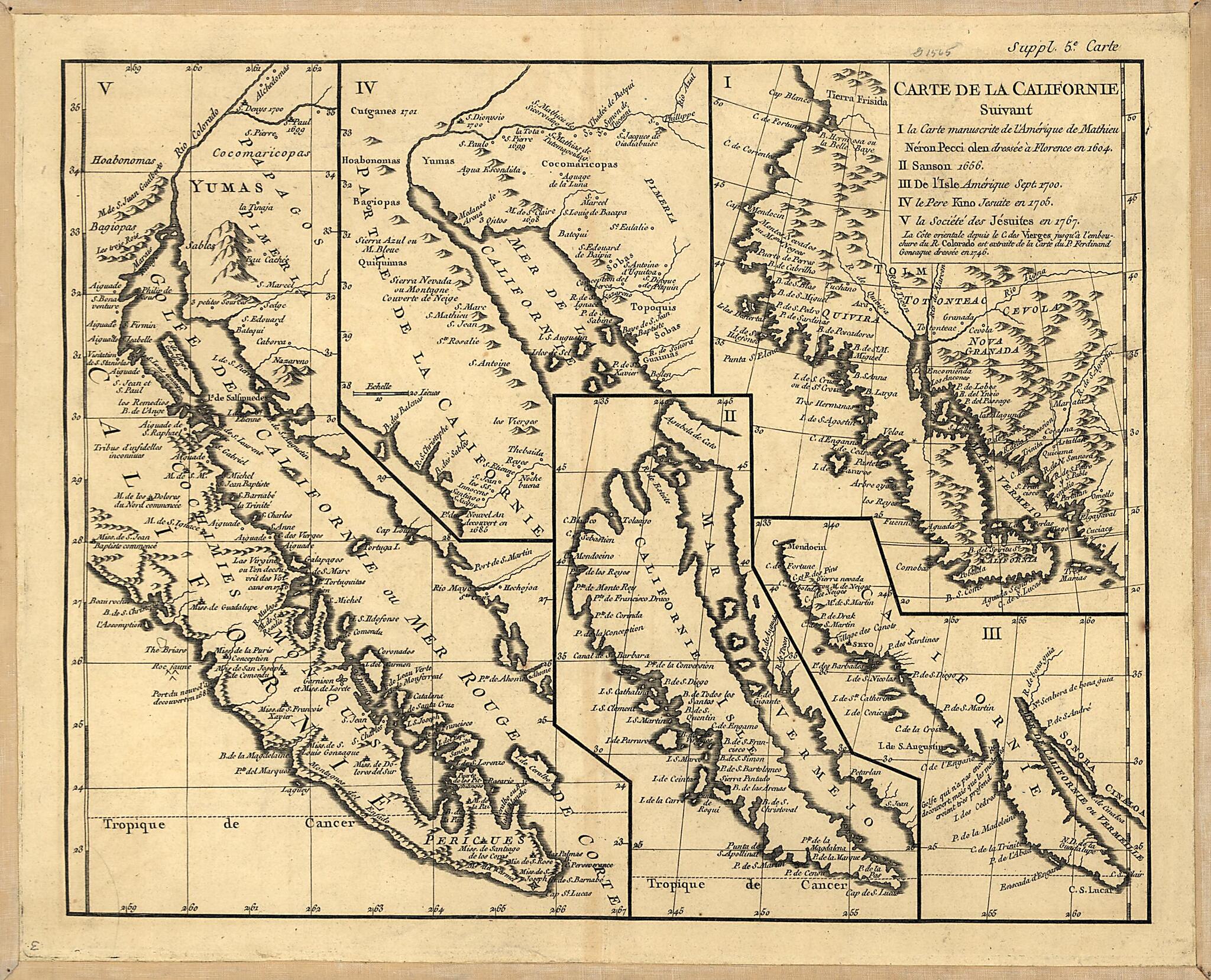
Carte De La Californie : Suivant I. La Carte Manuscrite De L'Amérique De Mathieu Néron Pecci Olen Dresses à Florence En 1604, II. Sanson 1656, III. De L'Isle Amérique Sept. 1700, IV. Le Pere Kino Jesuite En 1705, V. La Société Des Jésuites En 1...
- Regular price
-
$49.95 - Regular price
-
$29.95 - Sale price
-
$49.95
Buy one map, get any other map in our collection for 50% OFF! Add to cart to see discount.
Couldn't load pickup availability
About This Map
Discover the timeless beauty of our fine art quality printed reproduction of this antique map. Perfect for history enthusiasts, collectors, and interior decorators.
Restored with meticulous attention to detail by our team with over a decade of experience, this stunning reproduction captures the intricate artistry and historical significance of the original map.
Whether you're a collector or seeking a unique decor piece, this archival-quality map reproduction is a timeless addition to any space. Order now to bring history to life!
Old early map of Mexico, United States, West.Created by Didier Robert De Vaugondy in 1770.
- Relief shown pictorially.
- Shows 5 representations on 1 sheet of California, representing its delineation between 1604 and 1767.
- "La Côte orientale depuis le C. des Vierges jusqu'à l'embouchure du R. Colorado est extraite de la Carte du P. Ferdinand Gonsaque dressée en 1746."
- "Suppl, 5e Carte."
Map Subjects
Early Maps
Early Works To 1800
Mexico
United States
West
West (U.S.)
Didier Robert De Vaugondy
1770
- For the best legibility, order your map in the original size or larger. Most maps have intricate detail and small text that is best appreciated when the print size hasn't been reduced.
- Sizes labeled "Fits a Standard Frame" will drop right into any frame that you purchase in that size. The sizes that we offer are commonly available online and at most retail stores.
- Our standard sizes are recommendations based on the aspect ratio of the original map, but still may require some added "white space" in one dimension to fit.
- Non-standard sizes will require custom framing, and we suggest taking your print to the frame shop of your choice after you receive it for the best results.
- Custom sizes are available, simply contact us for a quote.
Below is an approximation of the scale of a few standard sizes, and how they might appear in your space.

