
Map of the Arabian Coast, Red Sea, and Persian Gulf. (Carte De La Coste D'Arabie, Mer Rouge, Et Golfe De Perse) 1745
- Regular price
-
$49.95 - Regular price
-
$34.95 - Sale price
-
$49.95
Buy one map, get any other map in our collection for 50% OFF! Add to cart to see discount.
Couldn't load pickup availability
About This Map
Discover the timeless beauty of our fine art quality printed reproduction of this antique map. Perfect for history enthusiasts, collectors, and interior decorators.
Restored with meticulous attention to detail by our team with over a decade of experience, this stunning reproduction captures the intricate artistry and historical significance of the original map.
Whether you're a collector or seeking a unique decor piece, this archival-quality map reproduction is a timeless addition to any space. Order now to bring history to life!
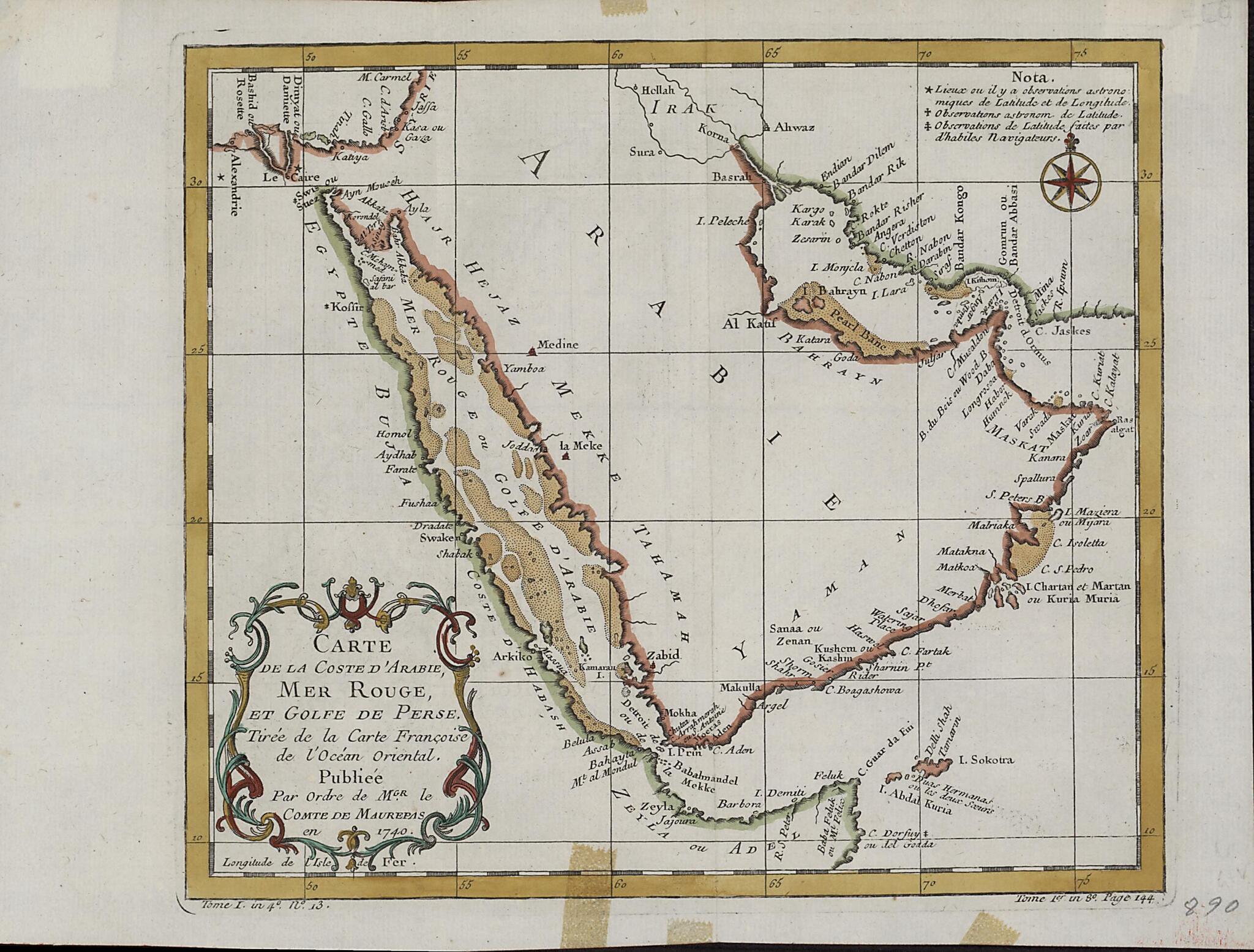
Old map of Bahrain, Djibouti, Egypt, Eritrea, Ethiopia, Iran, Islamic Republic of, Iraq, Israel, Jordan, Kuwait, Oman, Qatar, Saudi Arabia, Somalia, Sudan, United Arab Emirates, Yemen.Nicolas Bellin (1703-72). Bellin was attached to the French Marine Office for more than 50 years and specialized in producing maritime maps. He also made most of the maps for Histoire générale des voyages: ou, Nouvelle collection de toutes les relations de voyages par mer et par terre, qui ont été publiées jusqu'à présent dans les différentes langues de toutes les nations connues (General history of the voyages, or, a new collection of all the accounts of voyages on sea and on land, which have been published up to the present in the different languages of all known countries), a 15-volume compendium edited by Abbé Antoine-François Prévost (1697--1763) and published between 1746 and 1759. This map appeared in the first volume of this work. The map shows coastlines, ports, and coastal shoals. At a time when the determination of location was still an inexact science, a note at upper right explains the use of three different symbols on the map: a star to indicate places where location had been determined by astronomical observations of latitude and longitude; a cross to indicate places where location had been determined by astronomical observations of (only) latitude; and a modified cross to indicate places where location had been determined by latitudinal observations made by skilled navigators.
Created by Nicolas, François De in 1745.
- Title devised, in English, by Library staff.
- "Scale approximately 1:12,600,000"--Note extracted from World Digital Library.
- Original resource extent: 1 map ; 22 x 25 centimeters.
- Original resource at: Qatar National Library.
- Content in French.
- Description based on data extracted from World Digital Library, which may be extracted from partner institutions.
Map Subjects
1745 To 1746
Arabian Gulf
Arabian Peninsula
Bahrain
Djibouti
Egypt
Eritrea
Ethiopia
Iran Islamic Republic Of
Iraq
Israel
Jordan
Kuwait
Oman
Persian Gulf
Qatar
Red Sea
Saudi Arabia
Somalia
Sudan
United Arab Emirates
Yemen
Nicolas
François De
1745
- For the best legibility, order your map in the original size or larger. Most maps have intricate detail and small text that is best appreciated when the print size hasn't been reduced.
- Sizes labeled "Fits a Standard Frame" will drop right into any frame that you purchase in that size. The sizes that we offer are commonly available online and at most retail stores.
- Our standard sizes are recommendations based on the aspect ratio of the original map, but still may require some added "white space" in one dimension to fit.
- Non-standard sizes will require custom framing, and we suggest taking your print to the frame shop of your choice after you receive it for the best results.
- Custom sizes are available, simply contact us for a quote.
Below is an approximation of the scale of a few standard sizes, and how they might appear in your space.

