
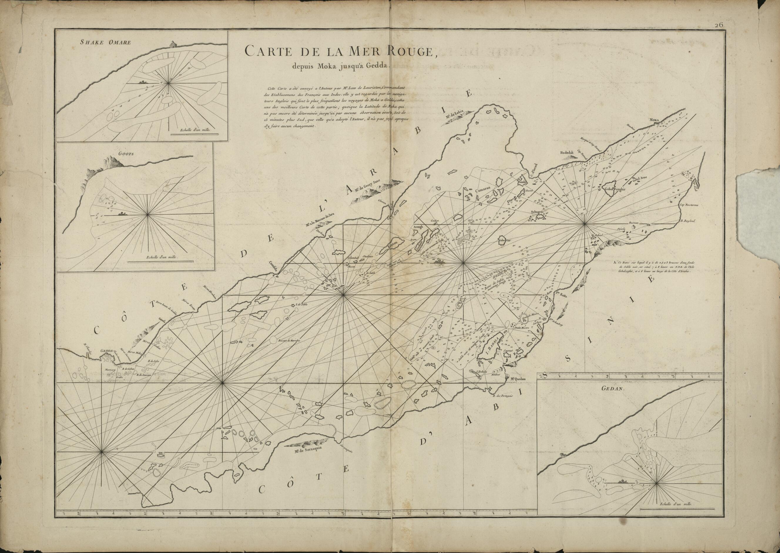
Map of the Red Sea from Mocha to Jeddah. (Carte De La Mer Rouge Depuis Moka Jusqu'à Gedda) 1775
- Regular price
-
$120.95 - Regular price
-
$115.95 - Sale price
-
$120.95
Buy one map, get any other map in our collection for 50% OFF! Add to cart to see discount.
Couldn't load pickup availability
About This Map
Discover the timeless beauty of our fine art quality printed reproduction of this antique map. Perfect for history enthusiasts, collectors, and interior decorators.
Restored with meticulous attention to detail by our team with over a decade of experience, this stunning reproduction captures the intricate artistry and historical significance of the original map.
Whether you're a collector or seeking a unique decor piece, this archival-quality map reproduction is a timeless addition to any space. Order now to bring history to life!
Old map of Eritrea, Jeddah, Makkah, Mocha, Saudi Arabia, Sudan, Tā'izz, Yemen.day Mocha, Yemen) shown at top right and Gedda (present-day Jeddah, Saudi Arabia), some 1,000 kilometers northwest, at the left edge of the map. As noted under the title, the original source of the map was Jean Law of Lauriston, commander of the French settlements in India in the mid-18th century. It was created in the form presented here by Jean-Baptiste-Nicolas-Denis d'Après de Mannevillette (1707-80), a celebrated French navigator, cartographer, and one of the first French hydrographers, who had a long and distinguished career in the Compagnie française pour le commerces des Indes orientales (French East India Company). D'Après Mannevillette studied under the famous Guillaume de L'Isle (1678-1756), the king's geographer. Using new instruments while on a voyage to China in 1728, he was able to correct the latitudes of many places. Upon his return to France, he corrected and published existing maps of the route to China: from the Red Sea to the coasts of India, Malaya, and the northern parts of Indonesia, Indochina, and China. From 1735 he began collecting charts and material about the navigation of Africa and the Indies. He also traveled extensively for this purpose. During his many voyages, d'Après de Mannevillette collected or created a number of charts for a hydrographic atlas, which, with the assistance of the Academie des Sciences, he published in Paris in 1745 as the Le Neptune oriental (The oriental navigator) with 22 maps. For the next 30 years, with the help of his friend the eminent British hydrographer Alexander Dalrymple, d'Après de Mannevillette revised his charts for a second and enlarged edition, which appeared in 1775 and contained 41 new charts. This comprehensive atlas was used on all French and many foreign ships when navigating the Indian Ocean.
Created by Baptiste-Nicolas-Denis D in 1775.
- Title devised, in English, by Library staff.
- "Scale approximately 1:1,710,000"--Note extracted from World Digital Library.
- Original resource extent: 1 map ; 66 x 49 centimeters.
- Original resource at: Qatar National Library.
- Content in French.
- Description based on data extracted from World Digital Library, which may be extracted from partner institutions.
- For the best legibility, order your map in the original size or larger. Most maps have intricate detail and small text that is best appreciated when the print size hasn't been reduced.
- Sizes labeled "Fits a Standard Frame" will drop right into any frame that you purchase in that size. The sizes that we offer are commonly available online and at most retail stores.
- Our standard sizes are recommendations based on the aspect ratio of the original map, but still may require some added "white space" in one dimension to fit.
- Non-standard sizes will require custom framing, and we suggest taking your print to the frame shop of your choice after you receive it for the best results.
- Custom sizes are available, simply contact us for a quote.
Below is an approximation of the scale of a few standard sizes, and how they might appear in your space.

