
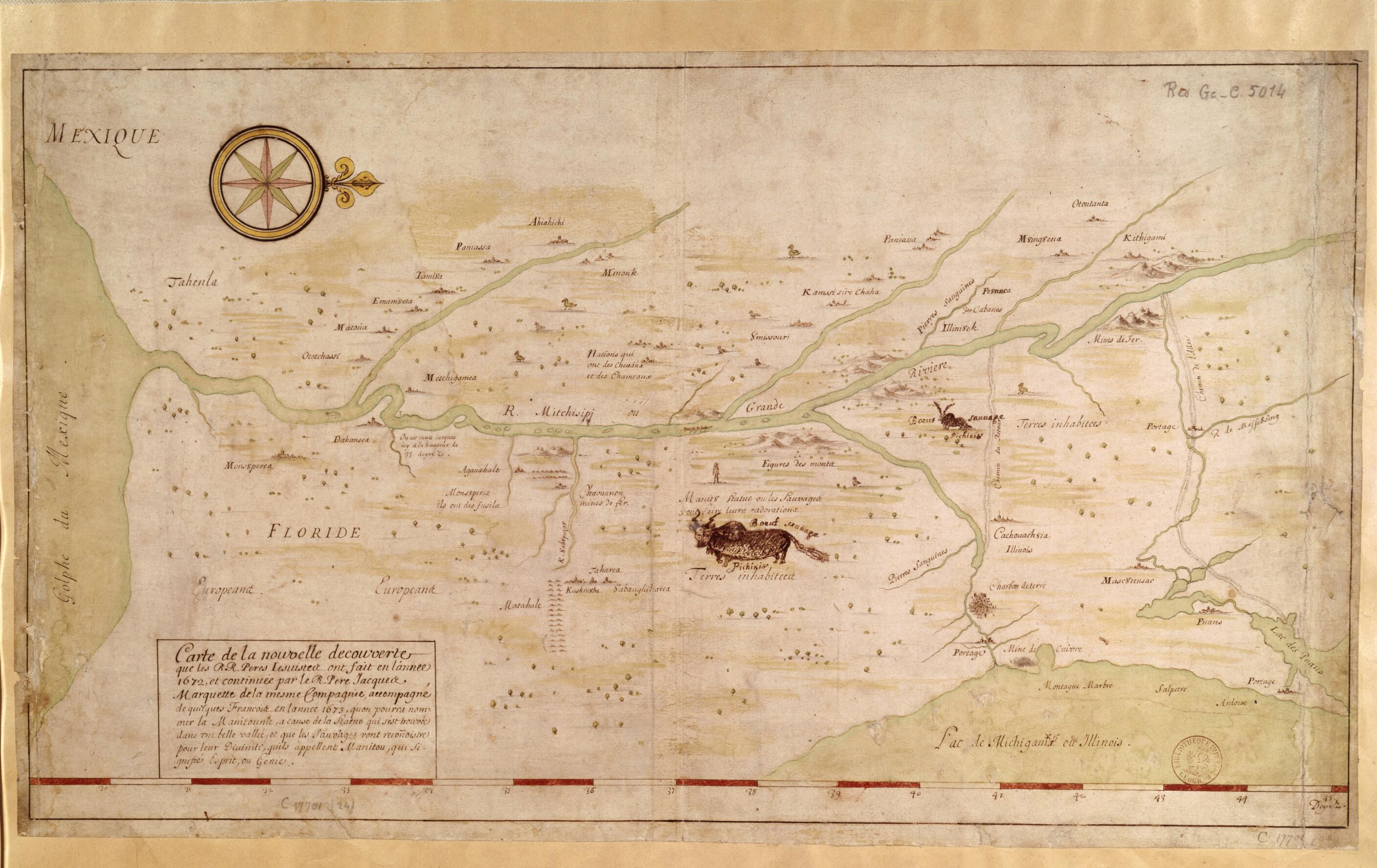
Map of the New Discovery Made by the Jesuit Fathers In 1672 and Continued by Father Jacques Marquette, from the Same Group, Accompanied by a Few Frenchmen In the Year 1673, Named Manitounie. (Carte De La Nouvelle Découverte Que Les RR. Pères Jésuit...
- Regular price
-
$49.95 - Regular price
-
$34.95 - Sale price
-
$49.95
Buy one map, get any other map in our collection for 50% OFF! Add to cart to see discount.
Couldn't load pickup availability
About This Map
Discover the timeless beauty of our fine art quality printed reproduction of this antique map. Perfect for history enthusiasts, collectors, and interior decorators.
Restored with meticulous attention to detail by our team with over a decade of experience, this stunning reproduction captures the intricate artistry and historical significance of the original map.
Whether you're a collector or seeking a unique decor piece, this archival-quality map reproduction is a timeless addition to any space. Order now to bring history to life!
Old map of Canada, United States of America.July 1673 the French cartographer and explorer Louis Jolliet (1645-1700) and the Jesuit priest Father Jacques Marquette (1637-75) were the first Europeans to descend the Mississippi River from the region of the Great Lakes to its confluence with the Arkansas River. Their goal was to locate a passage to the Pacific Ocean. They soon noticed, however, that the Mississippi ran south in the direction of the Gulf of Mexico rather than west to the Pacific. They suspended their journey in present-day Arkansas, after the Quapaw Indians warned them that farther south were Spanish colonists. This map indicates where they stopped, as well as iron and copper mines, the prairies inhabited by vast numbers of boeufs sauvages (bison), which are depicted in two crude drawings, and portages. Jolliet and Marquette called the region Manitounie, a Native American term referring to manitous (Indian spirits). The map is oriented with north on the right. It shows the entire region from Lake Michigan (also called Lake Illinois) to the Gulf of Mexico. Various Indian tribes and places-names are given. In the region west of the Mississippi between the Arkansas and Missouri Rivers, the local inhabitants are described as Nations qui ont des Chevaux et des Chameaux (Peoples with horses and camels; Marquette and Jolliet were mistaken about the latter, as no camelid species were present in North America in the 17th century). The Spanish territories of Florida and Mexico are indicated.
Created by Louis Jolliet, Jacques Marquette in 1673.
- Title devised, in English, by Library staff.
- Original resource extent: 1 map : manuscript, color ; 76 x 43 centimeters.
- Reference extracted from World Digital Library: J. Monet, "MARQUETTE, JACQUES," in Dictionary of Canadian Biography 1 (Toronto: University of Toronto/Université Laval, 2003-- ).|André Vachon, "JOLLIET, LOUIS," in Dictionary of Canadian Biography 1 (Toronto: University of Toronto/Université Laval, 2003-- ).
- Original resource at: National Library of France.
- Content in French.
- Description based on data extracted from World Digital Library, which may be extracted from partner institutions.
- For the best legibility, order your map in the original size or larger. Most maps have intricate detail and small text that is best appreciated when the print size hasn't been reduced.
- Sizes labeled "Fits a Standard Frame" will drop right into any frame that you purchase in that size. The sizes that we offer are commonly available online and at most retail stores.
- Our standard sizes are recommendations based on the aspect ratio of the original map, but still may require some added "white space" in one dimension to fit.
- Non-standard sizes will require custom framing, and we suggest taking your print to the frame shop of your choice after you receive it for the best results.
- Custom sizes are available, simply contact us for a quote.
Below is an approximation of the scale of a few standard sizes, and how they might appear in your space.
