
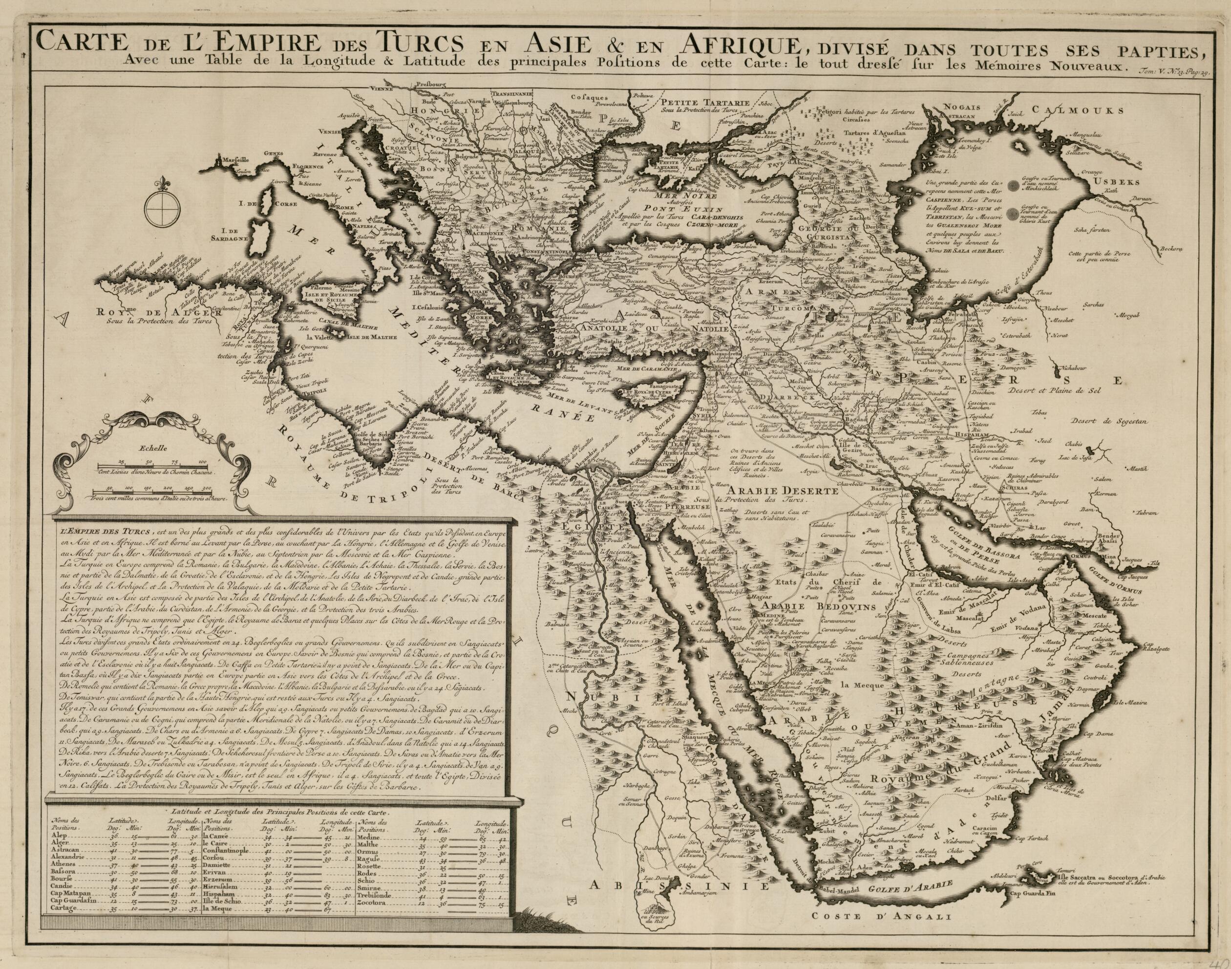
Map of the Empire of the Turks In Asia and Africa. (Carte De L'Empire Des Turcs En Asie & En Afrique: Divisé Dans Toutes Ses Papties: Avec Une Table De La Longitude & Latitude Des Principales Positions De Cette Carte: Le Tout Dressé Sur Les Mémoire...
- Regular price
-
$72.95 - Regular price
-
$67.95 - Sale price
-
$72.95
Buy one map, get any other map in our collection for 50% OFF! Add to cart to see discount.
Couldn't load pickup availability
About This Map
Discover the timeless beauty of our fine art quality printed reproduction of this antique map. Perfect for history enthusiasts, collectors, and interior decorators.
Restored with meticulous attention to detail by our team with over a decade of experience, this stunning reproduction captures the intricate artistry and historical significance of the original map.
Whether you're a collector or seeking a unique decor piece, this archival-quality map reproduction is a timeless addition to any space. Order now to bring history to life!
1743). It illustrates in detail the Ottoman Empire at the conclusion of the Great Turkish War (also called the War of the Holy League, 1683-99). The map thus reflects loss by the empire of most of its European possessions. It also shows the main caravan routes to Mecca and Medina from across the empire. The region shown extends from Italy and the Mediterranean in the west to the Caspian Sea and Persia in the east, and from the Black Sea and Ukraine in the north to the source of the Nile, the Red Sea, and the Arabian Gulf in the south. Accompanying text describes the Ottoman Empire. The map appeared in the monumental seven-volume Atlas Historique (Historical atlas) published in Amsterdam between 1705 and 1720 by Henri Abraham Chatelain, his father Zacharias Chatelain (died 1723), and his brother, also called Zacharias Chatelain (1690-1754). Many of the maps were based largely on works by the French cartographer Guillaume De L'Isle (1675-1726), but they were collected by the Chatelains and presented in encyclopedic form. The presentation included information not just about geography, cosmography, and topography, but also studies of history, heraldry, ethnography, and local costumes. The maps were published under several different Chatelain imprints. A second edition of the atlas appeared in 1732.Created by Henri Abraham Châtelain, Guillaume De L'isle in 1719.
- Title devised, in English, by Library staff.
- "Scale approximately 1:10,000,000"--Note extracted from World Digital Library.
- Original resource extent: 1 map ; 37 x 50 centimeters.
- Original resource at: Qatar National Library.
- Content in French.
- Description based on data extracted from World Digital Library, which may be extracted from partner institutions.
- For the best legibility, order your map in the original size or larger. Most maps have intricate detail and small text that is best appreciated when the print size hasn't been reduced.
- Sizes labeled "Fits a Standard Frame" will drop right into any frame that you purchase in that size. The sizes that we offer are commonly available online and at most retail stores.
- Our standard sizes are recommendations based on the aspect ratio of the original map, but still may require some added "white space" in one dimension to fit.
- Non-standard sizes will require custom framing, and we suggest taking your print to the frame shop of your choice after you receive it for the best results.
- Custom sizes are available, simply contact us for a quote.
Below is an approximation of the scale of a few standard sizes, and how they might appear in your space.

