
Map of the Ocean Showing the Different Routes of the Navigators Around the World. (Carte De L'Océan Où Sont Tracées Les Différentes Routes Des Navigateurs Au Tour Du Monde) 1785
- Regular price
-
$49.95 - Regular price
-
$34.95 - Sale price
-
$49.95
Buy one map, get any other map in our collection for 50% OFF! Add to cart to see discount.
Couldn't load pickup availability
About This Map
Discover the timeless beauty of our fine art quality printed reproduction of this antique map. Perfect for history enthusiasts, collectors, and interior decorators.
Restored with meticulous attention to detail by our team with over a decade of experience, this stunning reproduction captures the intricate artistry and historical significance of the original map.
Whether you're a collector or seeking a unique decor piece, this archival-quality map reproduction is a timeless addition to any space. Order now to bring history to life!
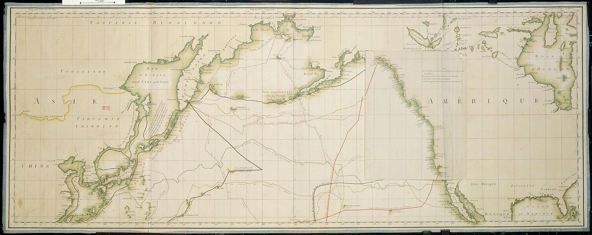
Old map of Canada, China, Democratic People's Republic of Korea, Japan, Mexico, Republic of Korea, Russian Federation, United States of America.Nicolas Buache (1741-1825) to plan and subsequently chart the discoveries made on the voyage around the world of the French explorer Jean-François de Galaup La Pérouse (1741-88). In 1783 the French government decided to send an expedition to the Pacific to complete the work begun by the British explorer James Cook, and in particular to chart the Bering Sea, the geography of which was still poorly understood by Europeans. La Pérouse, a naval officer who had distinguished himself in two wars, including the American Revolution, was chosen to head the expedition. The preparatory map made for La Pérouse's voyage constituted a veritable catalog of geographic uncertainties in the Pacific Ocean. The map showed both the planned itinerary of La Pérouse and the routes of the principal European voyages in the Pacific up to the 1780s. In North America, a large part of the coast between Mount Saint Elias (in present-day Alaska) and the port of Monterey had yet to be explored. Five copies of the map were made; one copy was sent to King Louis XVI, who had it filled in as he received news about the progress of the expedition. Findings from the exploration of the western coasts of America were carefully noted in a loose-leaf folio. The image showing La Pérouse's route and discoveries then could be superimposed, for direct comparison, on those showing the discoveries of Cook, the Spanish, and other explorers. La Pérouse sailed from Brest August 1, 1785. He made important discoveries in the North Pacific--determining, for example, that Sakhalin is an island--but he never made it back to France. In March 1788 he was shipwrecked at Vanikoro, Santa Cruz (present-day Solomon Islands).
Created by Nicolas, Comte De François De Galaup in 1785.
- Title devised, in English, by Library staff.
- Original resource extent: 1 map in 3 sheets : handwritten, accented with colors and lined with blue silk ; (1) 62.5 x 162.5 centimeters, (2) 59.5 x 182 centimeters, (3) 62.5 x 182 centimeters.
- Reference extracted from World Digital Library: Leslie R. Marchant, "La Pérouse, Jean-François de Galaup (1741--1788)," in Australian Dictionary of Biography (Canberra: National Centre of Biography, Australian National University, 1967- ).
- Original resource at: National Library of France.
- Content in French.
- Description based on data extracted from World Digital Library, which may be extracted from partner institutions.
Map Subjects
Canada
China
Cook James
Democratic People's Republic Of Korea
Exploration And Encounters
Explorers
Japan
François De Galaup Comte De
Manuscript Maps
Mexico
Pacific Ocean
Republic Of Korea
Russian Federation
United States Of America
Nicolas
Comte De François De Galaup
1785
- For the best legibility, order your map in the original size or larger. Most maps have intricate detail and small text that is best appreciated when the print size hasn't been reduced.
- Sizes labeled "Fits a Standard Frame" will drop right into any frame that you purchase in that size. The sizes that we offer are commonly available online and at most retail stores.
- Our standard sizes are recommendations based on the aspect ratio of the original map, but still may require some added "white space" in one dimension to fit.
- Non-standard sizes will require custom framing, and we suggest taking your print to the frame shop of your choice after you receive it for the best results.
- Custom sizes are available, simply contact us for a quote.
Below is an approximation of the scale of a few standard sizes, and how they might appear in your space.
