
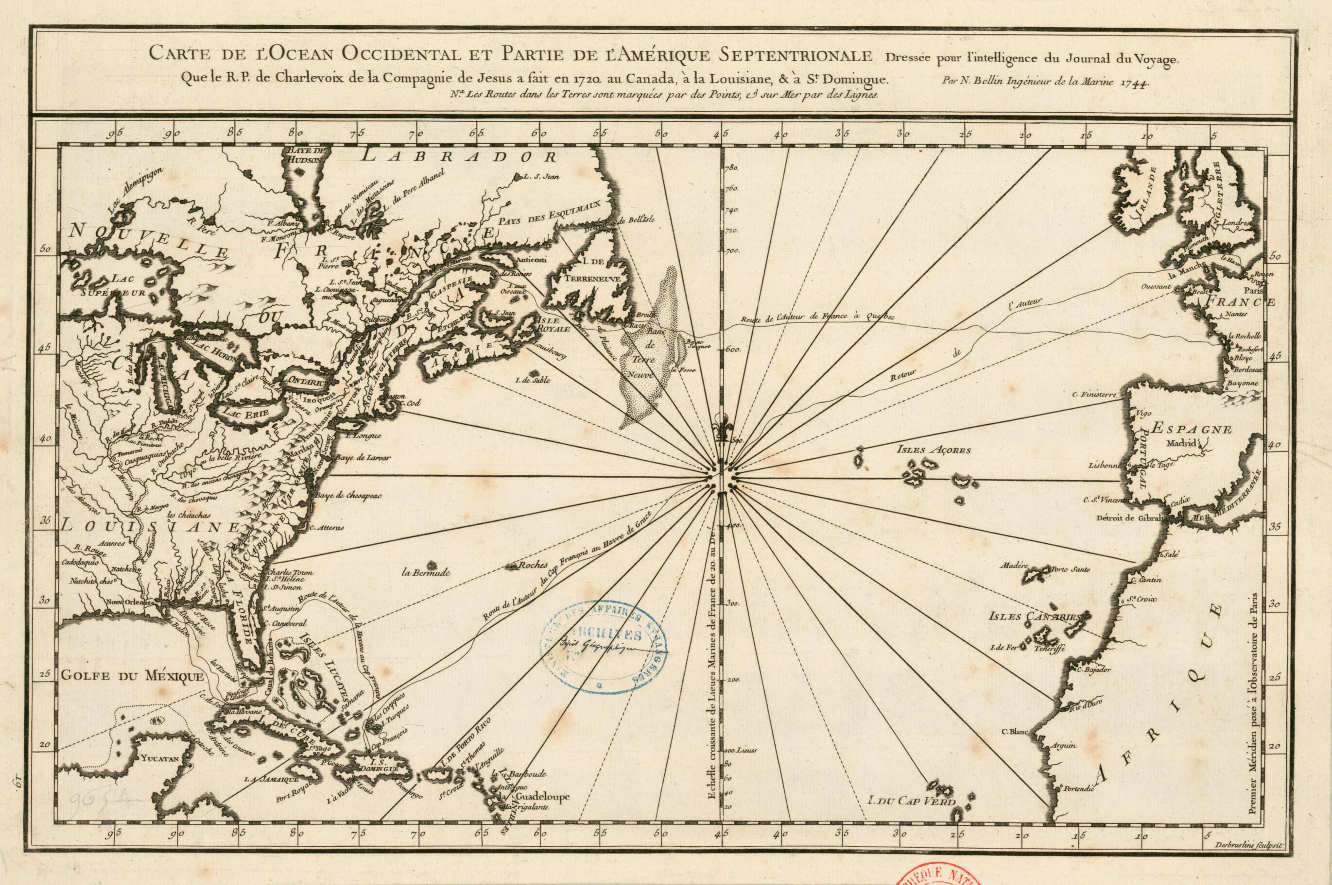
Domingue. (Carte De L'océan Occidental Et Partie De L'Amérique Septentrionale Dressée Pour L'intelligence Du Journal Du Voyage Que Le R.P. De Charlevoix De La Compagnie De Jesus a Fait En 1720 Au Canada, à La Louisiane & à St Domingue) 1744
- Regular price
-
$49.95 - Regular price
-
$34.95 - Sale price
-
$49.95
Buy one map, get any other map in our collection for 50% OFF! Add to cart to see discount.
Couldn't load pickup availability
About This Map
Discover the timeless beauty of our fine art quality printed reproduction of this antique map. Perfect for history enthusiasts, collectors, and interior decorators.
Restored with meticulous attention to detail by our team with over a decade of experience, this stunning reproduction captures the intricate artistry and historical significance of the original map.
Whether you're a collector or seeking a unique decor piece, this archival-quality map reproduction is a timeless addition to any space. Order now to bring history to life!
Old map of Canada, Cuba, Florida, France, Haiti, Louisiana, Quebec, United States of America.François-Xavier de Charlevoix was a French Jesuit priest who made a voyage to America in 1720-22. He had already taught in Quebec in 1705-9 and then was recalled to France. He departed Rochefort for New France on July 2, 1720, and arrived in Quebec on September 23 of that year. From there, he traveled to Montreal, Ontario, Niagara Falls, and as far as Lake Michigan. He then went down the Mississippi River to New Orleans, where he arrived on January 10, 1722. His vessel the Adour was shipwrecked in April 1722, making it impossible for him to reach his intended destination of Saint-Domingue (present-day Haiti). He traveled along the coast of Spanish Florida to Biloxi and then back to New Orleans, where he arrived on June 3, before eventually going to Cuba and Saint-Domingue, from where he departed for France. He arrived in Le Havre on December 26, 1722. He described his voyage in the third volume of his Histoire et description générale de la Nouvelle France (History and general description of New France), published in 1744. This map showing the route of Charlevoix's voyage is by Jacques Bellin (1703-72), a prolific cartographer attached to the French Marine Office. Bellin's maps and sea atlases reflect the careful mapping of bays, seas, and harbors that characterized 18th-century French naval cartography. The map is from the collection of the geographer Jean-Baptiste Bourguignon d'Anville (1697--1782). It was given to King Louis XVI in 1782 and deposited in the National Library of France in 1924.
Created by Nicolas, F. Desbrulins in 1744.
- Title devised, in English, by Library staff.
- Original resource extent: 1 map ; 27 x 40 centimeters.
- Original resource at: National Library of France.
- Content in French.
- Description based on data extracted from World Digital Library, which may be extracted from partner institutions.
- For the best legibility, order your map in the original size or larger. Most maps have intricate detail and small text that is best appreciated when the print size hasn't been reduced.
- Sizes labeled "Fits a Standard Frame" will drop right into any frame that you purchase in that size. The sizes that we offer are commonly available online and at most retail stores.
- Our standard sizes are recommendations based on the aspect ratio of the original map, but still may require some added "white space" in one dimension to fit.
- Non-standard sizes will require custom framing, and we suggest taking your print to the frame shop of your choice after you receive it for the best results.
- Custom sizes are available, simply contact us for a quote.
Below is an approximation of the scale of a few standard sizes, and how they might appear in your space.
