
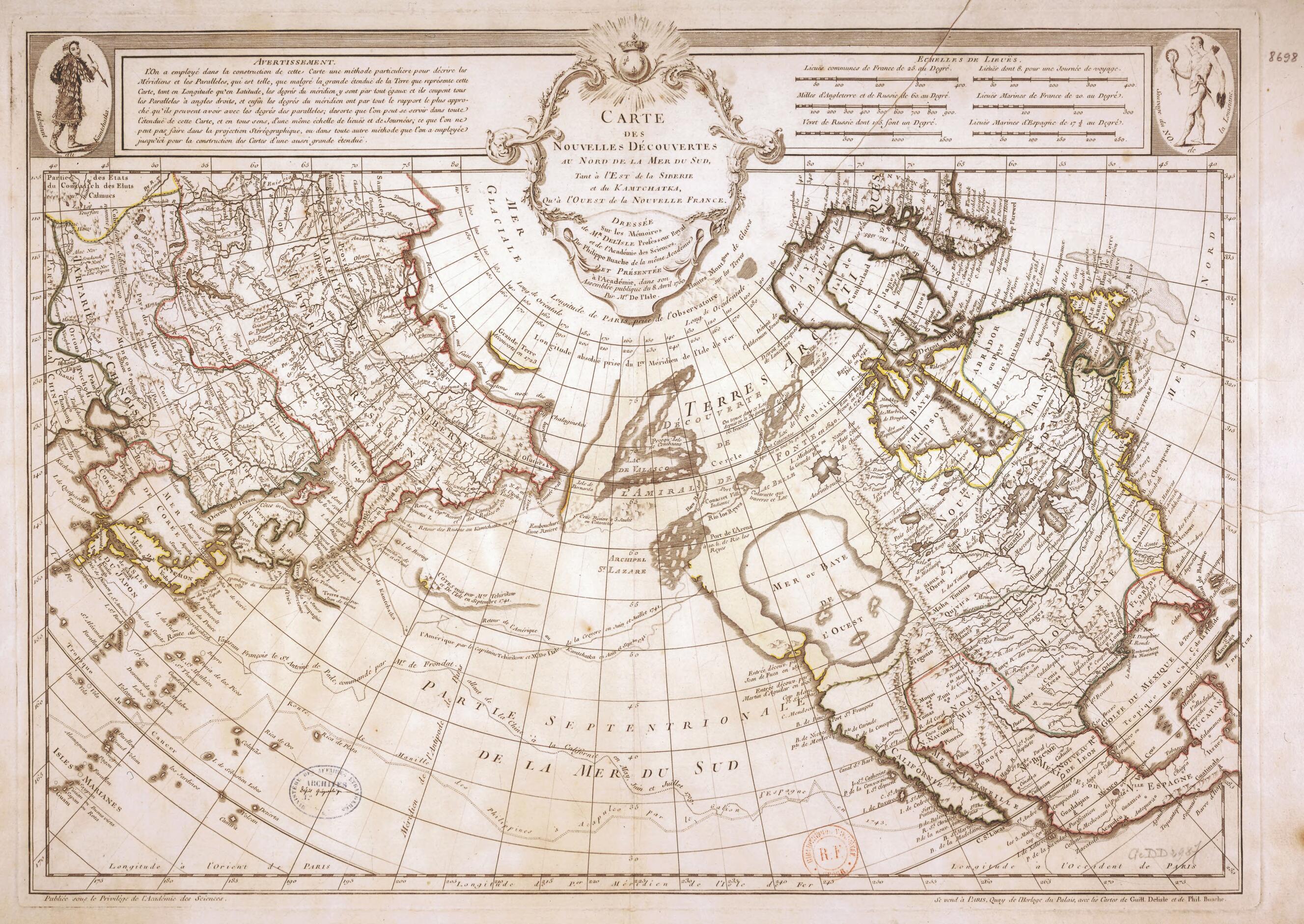
Map of New Discoveries North of the South Sea, In Eastern Siberia and Kamchatka, and In Western New France. (Carte Des Nouvelles Découvertes Au Nord De La Mer Du Sud Tant à L'est De La Sibérie Et Du Kamtchatka Qu'à L'ouest De La Nouvelle France) 1750
- Regular price
-
$49.95 - Regular price
-
$34.95 - Sale price
-
$49.95
Buy one map, get any other map in our collection for 50% OFF! Add to cart to see discount.
Couldn't load pickup availability
About This Map
Discover the timeless beauty of our fine art quality printed reproduction of this antique map. Perfect for history enthusiasts, collectors, and interior decorators.
Restored with meticulous attention to detail by our team with over a decade of experience, this stunning reproduction captures the intricate artistry and historical significance of the original map.
Whether you're a collector or seeking a unique decor piece, this archival-quality map reproduction is a timeless addition to any space. Order now to bring history to life!
Old map of Canada, China, Democratic People's Republic of Korea, Japan, Mexico, Republic of Korea, Russian Federation, United States of America.73), son-in-law of the great French cartographer Guillaume de L'Isle (1675-1726), and Joseph-Nicolas de L'Isle (1688-1768), brother of Guillaume de L'Isle. The map is centered on the North Pacific Ocean, referred to here as the northern part of the Southern Sea, and shows an enormous "Bay or Western Sea" cutting deeply into the Pacific coast of western Canada. Buache and de L'Isle based the map on the pseudo-discoveries of Bartholomew de Fonte, a Spanish admiral who was purported to have made a journey to the northwest coast of North America in around 1640 and discovered a passage linking the Pacific and Atlantic oceans. De Fonte's supposed findings were published in 1708 in a London magazine, Monthly Miscellany or Memoirs for the Curious. There is no evidence that de Fonte made the claimed discoveries or that he even existed. Buache and de L'Isle both were experienced cartographers, and de L'Isle had worked for a time in Saint Petersburg, where he learned about Russian explorations in the North Pacific (several Russian voyages in the region are marked on this map). Both men nonetheless were taken in by de Fonte, who appears to have been a fictional creation of the London magazine editor or a contributor.
Created by Philippe Buache, Nicolas De in 1750.
- Title devised, in English, by Library staff.
- "Scale about 1:21,000,000"--Note extracted from World Digital Library.
- Original resource extent: 1 map : illustrations and colored contours ; 53.5 x 72.5 centimeters.
- Reference extracted from World Digital Library: Willard E. Ireland, "FONTE, BARTHOLOMEW DE," in Dictionary of Canadian Biography 1 (Toronto: University of Toronto/Université Laval, 2003-- ).
- Original resource at: National Library of France.
- Content in French.
- Description based on data extracted from World Digital Library, which may be extracted from partner institutions.
- For the best legibility, order your map in the original size or larger. Most maps have intricate detail and small text that is best appreciated when the print size hasn't been reduced.
- Sizes labeled "Fits a Standard Frame" will drop right into any frame that you purchase in that size. The sizes that we offer are commonly available online and at most retail stores.
- Our standard sizes are recommendations based on the aspect ratio of the original map, but still may require some added "white space" in one dimension to fit.
- Non-standard sizes will require custom framing, and we suggest taking your print to the frame shop of your choice after you receive it for the best results.
- Custom sizes are available, simply contact us for a quote.
Below is an approximation of the scale of a few standard sizes, and how they might appear in your space.

