
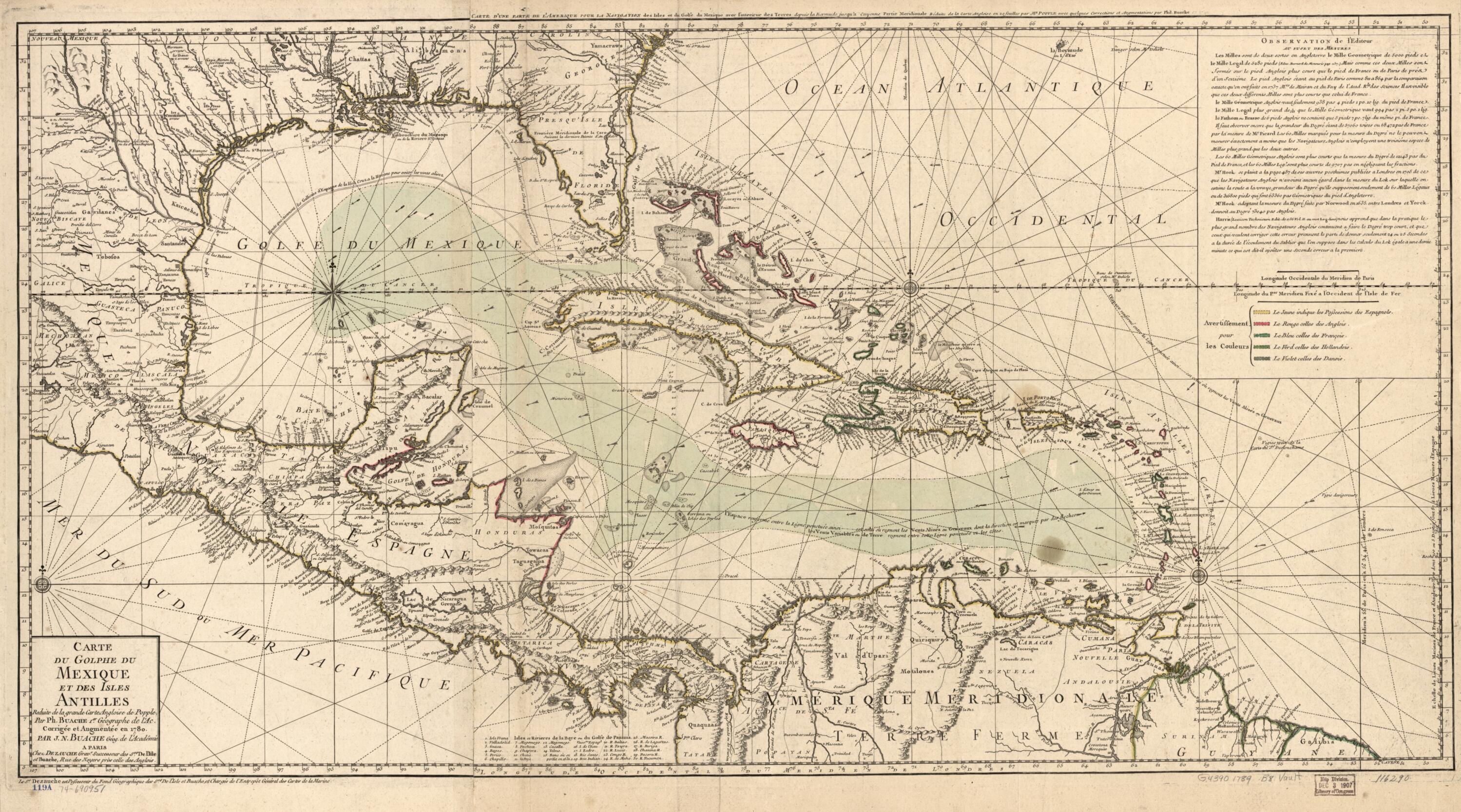
Carte Du Golphe Du Mexique Et Des Isles Antilles, Reduite De La Grande Carte Angloise De Popple 1789
- Regular price
-
$140.95 - Regular price
-
$135.95 - Sale price
-
$140.95
Buy one map, get any other map in our collection for 50% OFF! Add to cart to see discount.
Couldn't load pickup availability
About This Map
Discover the timeless beauty of our fine art quality printed reproduction of this antique map. Perfect for history enthusiasts, collectors, and interior decorators.
Restored with meticulous attention to detail by our team with over a decade of experience, this stunning reproduction captures the intricate artistry and historical significance of the original map.
Whether you're a collector or seeking a unique decor piece, this archival-quality map reproduction is a timeless addition to any space. Order now to bring history to life!
Old early map / nautical chart of Caribbean Area.Created by Nicolas, Philippe Buache, Dezauche, Henry Popple in 1789.
- Scale ca. 1:6,500,000.
- Hand colored.
- Prime meridian: Paris.
- Relief shown pictorially. Depths shown by soundings.
- Title in margin: Carte d'une part[i]e de l'Amerique pour la navigation des isles et du Golfe du Mexique avec l'interieur des terres depuis la Bermude jusqu'a Cayenne, partie meridionale, réduite de la carte angloise en 20 feuilles par Mr. Popple avec quelques corrections et augmentations par Phil. Buache.
- European possessions shown by colors.
- Shows Spanish ownership of Florida.
- Appears in Guillaume de l'Isle and the author's Atlas geographique et universel. 1781 [i.e. 1784] v. 2, no. 132.
- Includes text and index.
- For the best legibility, order your map in the original size or larger. Most maps have intricate detail and small text that is best appreciated when the print size hasn't been reduced.
- Sizes labeled "Fits a Standard Frame" will drop right into any frame that you purchase in that size. The sizes that we offer are commonly available online and at most retail stores.
- Our standard sizes are recommendations based on the aspect ratio of the original map, but still may require some added "white space" in one dimension to fit.
- Non-standard sizes will require custom framing, and we suggest taking your print to the frame shop of your choice after you receive it for the best results.
- Custom sizes are available, simply contact us for a quote.
Below is an approximation of the scale of a few standard sizes, and how they might appear in your space.
