

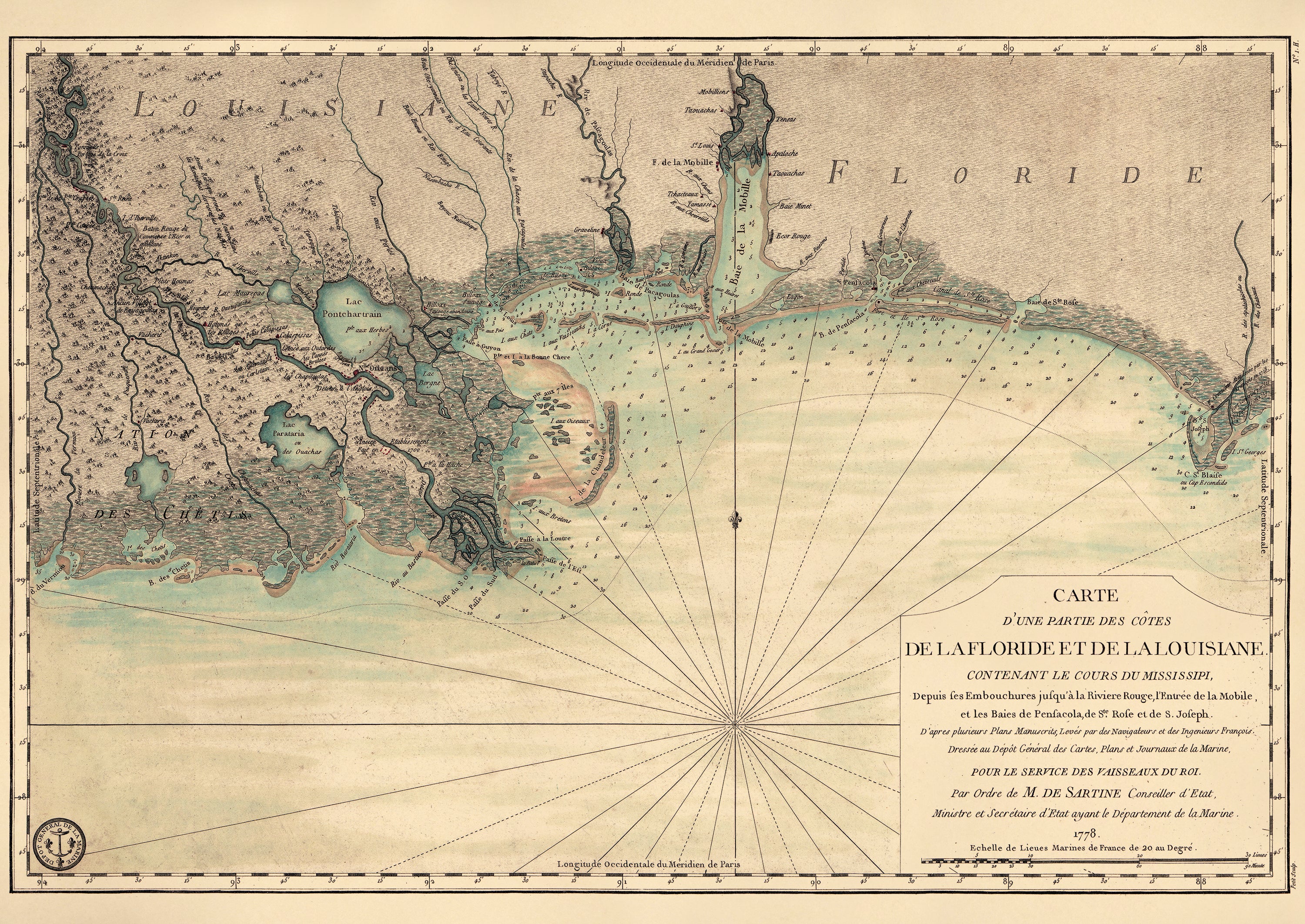
Carte D'une Partie Des Côtes De La Floride Et De La Louisiane, Contenant Le Cours Du Mississipi, Depuis Ses Embouchures Jusqu'à La Rivière Rouge, L'entrée De La Mobile Et Les Baies De Pensacola, De Ste. Rose Et De S. Joseph 1778
- Regular price
-
$58.95 - Regular price
-
$41.95 - Sale price
-
$58.95
Buy one map, get any other map in our collection for 50% OFF! Add to cart to see discount.
Couldn't load pickup availability
About This Map
Discover the timeless beauty of our fine art quality printed reproduction of this antique map. Perfect for history enthusiasts, collectors, and interior decorators.
Restored with meticulous attention to detail by our team with over a decade of experience, this stunning reproduction captures the intricate artistry and historical significance of the original map.
Whether you're a collector or seeking a unique decor piece, this archival-quality map reproduction is a timeless addition to any space. Order now to bring history to life!
Old early map of Florida, Gulf Coast, Louisiana, Lousiana, United States.Created by France. Dépôt Des Cartes Et Plans De La Marine, Petit, Antoine De Sartine in 1778.
- Scale ca. 1:1,125,000.
- Hand colored.
- Relief shown by hachures. Depths shown by soundings.
- "Longitude occidentale du méridien de Paris."
- "No. 1. H."
Map Subjects
Early Maps
Early Works To 1800
Florida
Gulf Coast
Gulf Coast (Fla.)
Gulf Coast (La.)
Gulf Coast (U.S.)
Lousiana
United States
Louisiana
France. Dépôt Des Cartes Et Plans De La Marine
Petit
Antoine De Sartine
1778
- For the best legibility, order your map in the original size or larger. Most maps have intricate detail and small text that is best appreciated when the print size hasn't been reduced.
- Sizes labeled "Fits a Standard Frame" will drop right into any frame that you purchase in that size. The sizes that we offer are commonly available online and at most retail stores.
- Our standard sizes are recommendations based on the aspect ratio of the original map, but still may require some added "white space" in one dimension to fit.
- Non-standard sizes will require custom framing, and we suggest taking your print to the frame shop of your choice after you receive it for the best results.
- Custom sizes are available, simply contact us for a quote.
Below is an approximation of the scale of a few standard sizes, and how they might appear in your space.

