
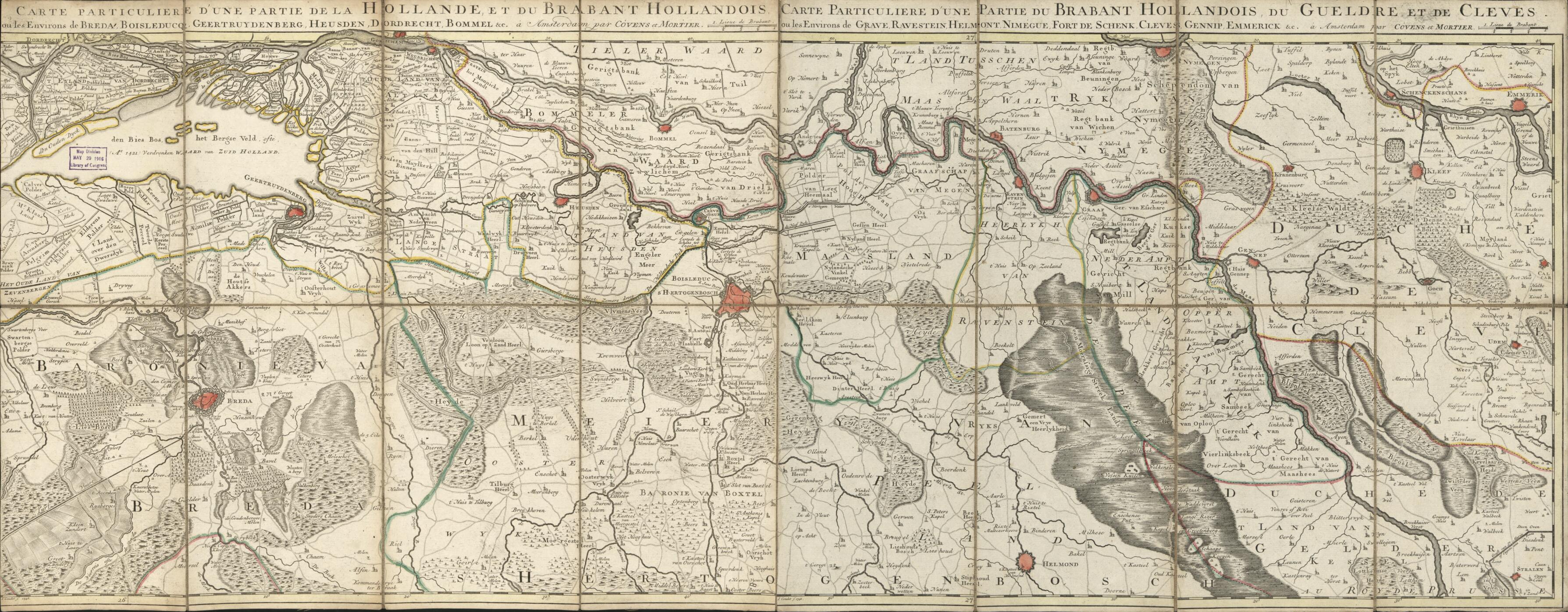
Carte Particulière D'une Partie De La Hollande Et Du Brabant Hollandois : Ou Les Environs De Breda, Boisleducq, Geertruydenberg, Heusden, Dordrecht, Bommel &c. : Carte Particulière D'une Partie Du Brabant Hollandois Du Gueldre Et De Cleves : Ou Les ...
- Regular price
-
$83.95 - Regular price
-
$78.95 - Sale price
-
$83.95
Buy one map, get any other map in our collection for 50% OFF! Add to cart to see discount.
Couldn't load pickup availability
About This Map
Discover the timeless beauty of our fine art quality printed reproduction of this antique map. Perfect for history enthusiasts, collectors, and interior decorators.
Restored with meticulous attention to detail by our team with over a decade of experience, this stunning reproduction captures the intricate artistry and historical significance of the original map.
Whether you're a collector or seeking a unique decor piece, this archival-quality map reproduction is a timeless addition to any space. Order now to bring history to life!
Old early map of Breda Region, Netherlands, North Brabant.Created by Johannes Condet, Cóvens Et Mortier, Millard Fillmore in 1748.
- Regional map covering North Brabant province (Netherlands) and adjacent regions.
- Relief shown pictorially.
- Hand colored to emphasize administrative boundaries and major city areas.
- Prime meridian: Ferro.
- This map is actually a combination of 2 separately published maps--as indicated by the 2 titles (each one beginning with "Carte particulière").
- When affixed to the cloth backing the 2 maps sheets were conjoined and sectioned to 16 panels to enable folding.
- Two handwritten (cursive script) inked map identification slips are affixed to the lower left panel of the cloth backing (verso): Carte-1748 du Brabant, du Gueldre et de Cleve -- [signature] Millard Fillmore, June 1856.
- Includes 2 titles, 2 statements of attribution, and 2 bar scales (in upper margin).
- For the best legibility, order your map in the original size or larger. Most maps have intricate detail and small text that is best appreciated when the print size hasn't been reduced.
- Sizes labeled "Fits a Standard Frame" will drop right into any frame that you purchase in that size. The sizes that we offer are commonly available online and at most retail stores.
- Our standard sizes are recommendations based on the aspect ratio of the original map, but still may require some added "white space" in one dimension to fit.
- Non-standard sizes will require custom framing, and we suggest taking your print to the frame shop of your choice after you receive it for the best results.
- Custom sizes are available, simply contact us for a quote.
Below is an approximation of the scale of a few standard sizes, and how they might appear in your space.
