
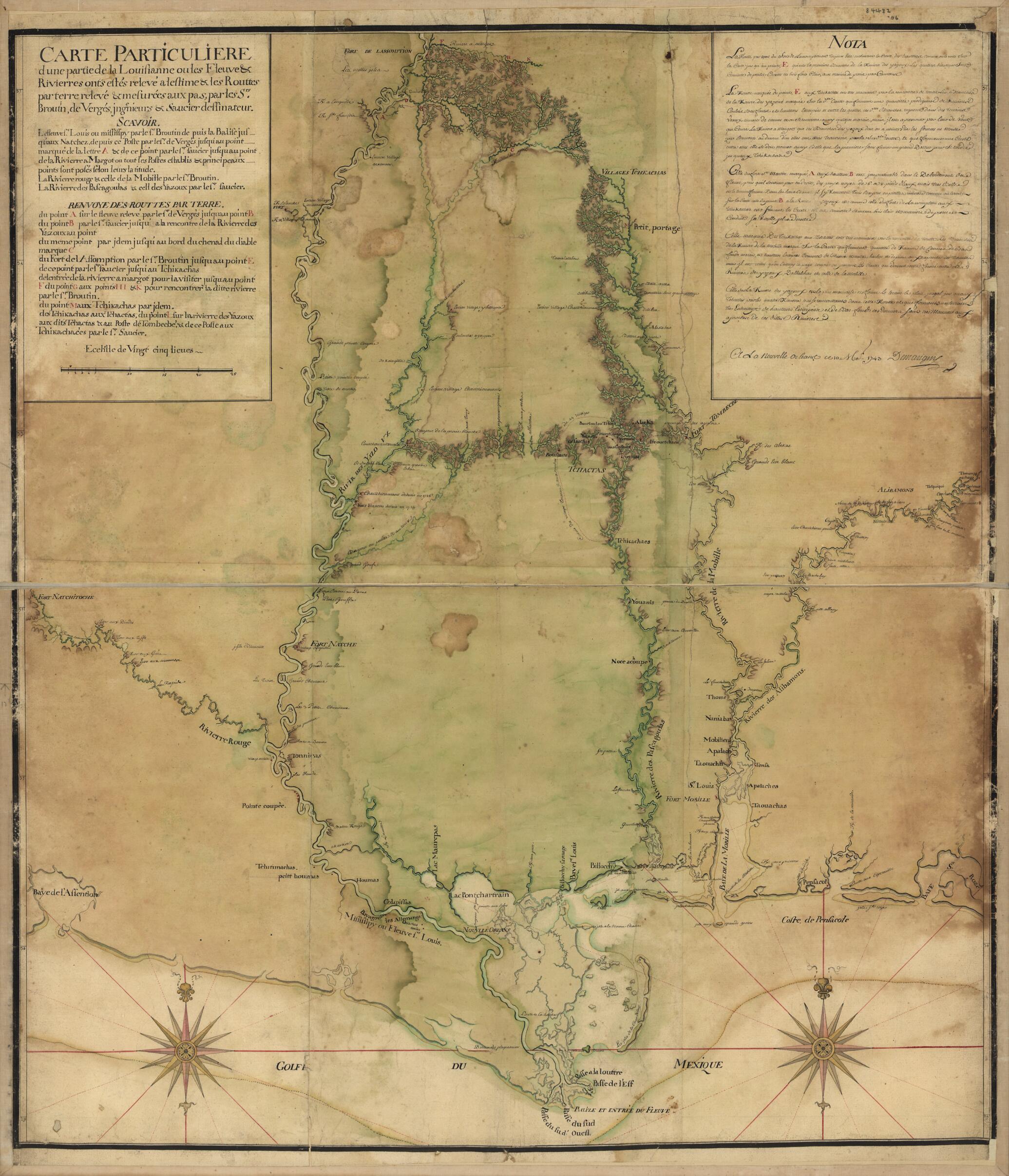
Carte Particulière D'une Partie De La Louisianne Ou Les Fleuve Et Rivierres i.e. Rivières Onts Etés Relevé a L'estime & Les Routtes i.e. Routes Par Terre Relevé & Mesurées Aux Pas, Par Les Srs. Broutin, De Vergés, Ingénieurs & Saucier Dessinat...
- Regular price
-
$108.95 - Regular price
-
$103.95 - Sale price
-
$108.95
Buy one map, get any other map in our collection for 50% OFF! Add to cart to see discount.
Couldn't load pickup availability
About This Map
Discover the timeless beauty of our fine art quality printed reproduction of this antique map. Perfect for history enthusiasts, collectors, and interior decorators.
Restored with meticulous attention to detail by our team with over a decade of experience, this stunning reproduction captures the intricate artistry and historical significance of the original map.
Whether you're a collector or seeking a unique decor piece, this archival-quality map reproduction is a timeless addition to any space. Order now to bring history to life!
Old map of Alabama, Louisiana, Mississippi River Valley, United States.Created by Demarigny in 1743.
- Pen-and-ink and watercolor.
- Map in 2 sections mounted on cloth backing.
- Prime meridian: [Paris].
- "This map of the Mississippi River Valley from Memphis to the Gulf of Mexico as far east as Mobile includes interior streams, routes, European communities, and Native American settlements and nations, fortifications ... Map concentrates on the surveys of Broutin, Vergés, and Saucier in Mississippi and Alabama ..."
- Includes text.
- Copy annotated in pencil in upper margin: 84482.06.
- Copy This map has some imperfections: waterstained. We'll do our best to restore the image before printing.
- For the best legibility, order your map in the original size or larger. Most maps have intricate detail and small text that is best appreciated when the print size hasn't been reduced.
- Sizes labeled "Fits a Standard Frame" will drop right into any frame that you purchase in that size. The sizes that we offer are commonly available online and at most retail stores.
- Our standard sizes are recommendations based on the aspect ratio of the original map, but still may require some added "white space" in one dimension to fit.
- Non-standard sizes will require custom framing, and we suggest taking your print to the frame shop of your choice after you receive it for the best results.
- Custom sizes are available, simply contact us for a quote.
Below is an approximation of the scale of a few standard sizes, and how they might appear in your space.

