
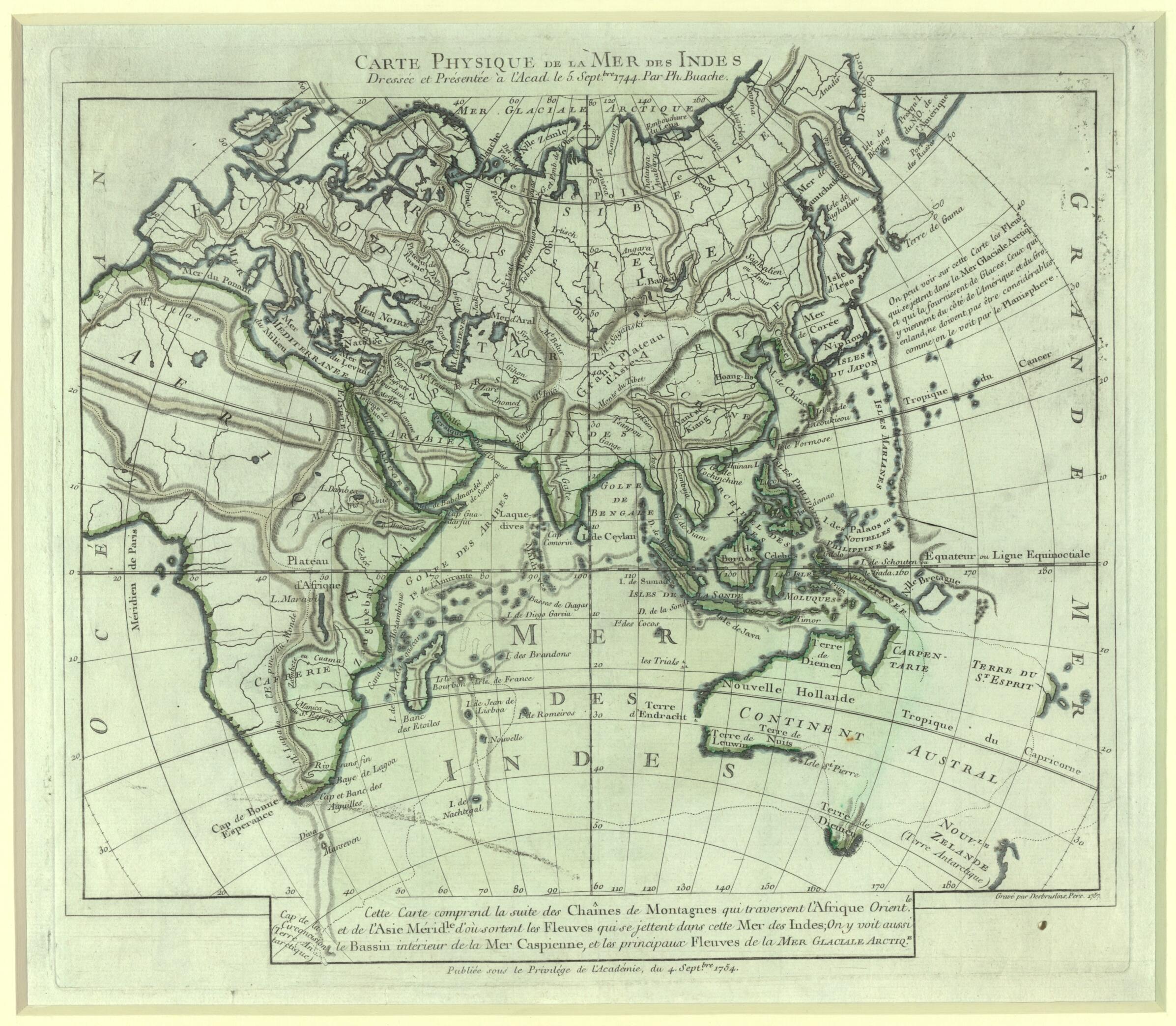
Physical Map of the Indian Ocean. (Carte Physique De La Mer Des Indes) 1757
- Regular price
-
$56.95 - Regular price
-
$39.95 - Sale price
-
$56.95
Shipping calculated at checkout.
Buy one map, get any other map in our collection for 50% OFF! Add to cart to see discount.
Couldn't load pickup availability
About This Map
1773) was one of the most prominent geographers of the 18th century at a time when Paris was a center for cartography. He studied mathematics and architecture and was the preeminent student of the French cartographer Guillaume de L'Isle (1675--1726). Buache went on to marry de L'Isle's daughter and inherit his workshop. In 1729 he became the principal geographer to the king and the following year was elected to the Académie des Sciences as de L'Isle's successor. Buache was known for his theoretical work in physical geography. He was one of the first cartographers to use contour lines to represent relief on maps. He published a number of major works including Considérations géographiques et physiques sur les nouvelles découvertes au nord de la Grande Mer (Geographical and physical considerations of the new discoveries to the north of the Great Sea, 1753), Le parallèle des fleuves des quatre parties du Monde, pour servir a déterminer les hauteurs des montagnes du Globe physique de la Terre (A comparison of the rivers of the four parts of the world, in order to determine the heights of the mountains of the physical globe of the earth, 1753), Mémoire sur les différentes idées qu'on a eues de la traversée de la mer glaciale arctique (Treatise on the various ideas considered for crossing the frozen Arctic Sea,1754), and Considérations géographiques et physiques sur les terres australes et antarctiques (Geographical and physical issues of the southern and Antarctic lands, 1761). This map was based on a presentation to the Académie des Sciences in 1744, although it was only published some ten years later. Buache was significant for formulating a theory about the importance of watersheds in physical geography. This map is intended as an illustration of that theory, as can be seen in the systems of mountain ranges forming basins from which the rivers issue and flow into the oceans. The map is indicative of a careful scientific mind; the continent of Australia, for example, is only delineated according to the latest discoveries and left in an unfinished state. The Paris meridian is demarcated, although the map uses the older Ferro meridian, located farther to the west, as its prime meridian. The map was engraved by F. Desbruslins in 1757.
Created by Philippe Buache, Active 18th Century Desbruslins in 1757.
Created by Philippe Buache, Active 18th Century Desbruslins in 1757.
- Title devised, in English, by Library staff.
- "This plate is from: Cartes et tables de la géographie physique ou naturelle.|Map scale 1:75,000,000"--Note extracted from World Digital Library.
- Original resource extent: 1 map : color ; 30 x 34 centimeters.
- Original resource at: Qatar National Library.
- Content in French.
- Description based on data extracted from World Digital Library, which may be extracted from partner institutions.
Map Sizing Information
- For the best legibility, order your map in the original size or larger. Most maps have intricate detail and small text that is best appreciated when the print size hasn't been reduced.
- Sizes labeled "Fits a Standard Frame" will drop right into any frame that you purchase in that size. The sizes that we offer are commonly available online and at most retail stores.
- Our standard sizes are recommendations based on the aspect ratio of the original map, but still may require some added "white space" in one dimension to fit.
- Non-standard sizes will require custom framing, and we suggest taking your print to the frame shop of your choice after you receive it for the best results.
- Custom sizes are available, simply contact us for a quote.
Below is an approximation of the scale of a few standard sizes, and how they might appear in your space.

