
Codex Totomixtlahuaca. (Códice Totomixtlahuaca) 1584
- Regular price
-
$49.95 - Regular price
-
$34.95 - Sale price
-
$49.95
Buy one map, get any other map in our collection for 50% OFF! Add to cart to see discount.
Couldn't load pickup availability
About This Map
Discover the timeless beauty of our fine art quality printed reproduction of this antique map. Perfect for history enthusiasts, collectors, and interior decorators.
Restored with meticulous attention to detail by our team with over a decade of experience, this stunning reproduction captures the intricate artistry and historical significance of the original map.
Whether you're a collector or seeking a unique decor piece, this archival-quality map reproduction is a timeless addition to any space. Order now to bring history to life!
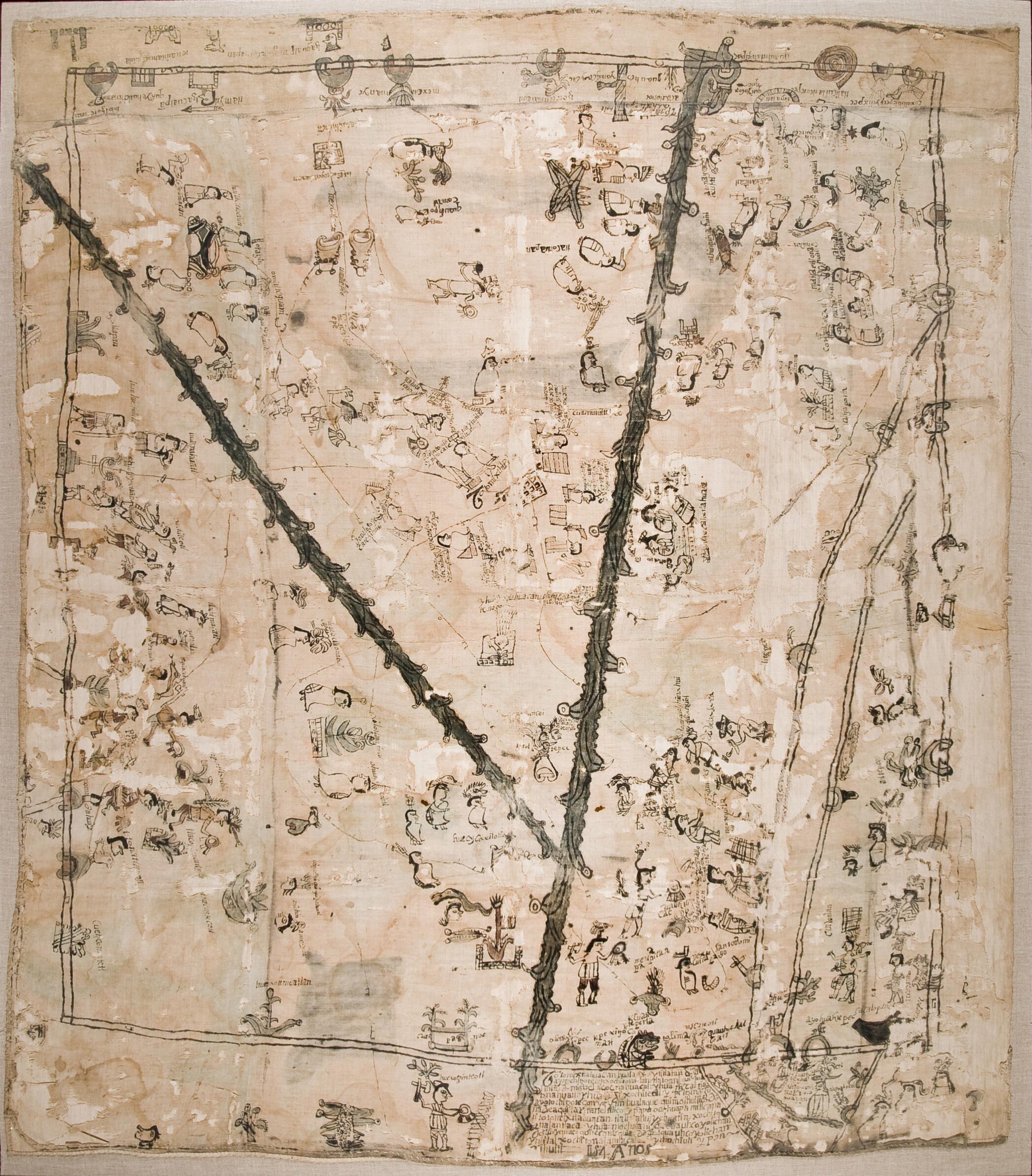
Old map of Guerrero, Mexico.era map from the Mixtecan, Tlapaneca, and Nahua cultural area in the present-day state of Guerrero, Mexico. It refers, principally, to the settlement called Totomixtlahuacan and states that the document was written in 1584. It is an indigenous colonial map that makes abundant use of Mesoamerican pictorial conventions and includes many texts written in Nahuatl, the most widespread Mesoamerican language. The map describes a geographical area, framed by various identified towns and crossed by two rivers. Different individuals, probably noble landowners, are mentioned in various open spaces. The drawings of plants or animals are not decorative elements: their purpose is to describe the characteristics of the land or of agricultural parcels, or they are in themselves the glyphic names of people and places that also convey their names in Nahuatl. Crosses are used to denote churches. Place names, such as Santo Domingo, are in Spanish. The main text refers to the meeting of the tlahtoani, or lord of Xochitonalan, and various other lords in Totomixtlahuacan, to clarify ownership of the land in this locale. The map is from the collection of CONDUMEX, and was acquired by auction in San Francisco, California, in 1973.
- Title devised, in English, by Library staff.
- Original resource extent: 195 x 171 centimeters; carbon ink on cotton.
- Original resource at: Center for the Study of the History of Mexico CARSO.
- Content in Classical Nahuatl and Spanish.
- Description based on data extracted from World Digital Library, which may be extracted from partner institutions.
- For the best legibility, order your map in the original size or larger. Most maps have intricate detail and small text that is best appreciated when the print size hasn't been reduced.
- Sizes labeled "Fits a Standard Frame" will drop right into any frame that you purchase in that size. The sizes that we offer are commonly available online and at most retail stores.
- Our standard sizes are recommendations based on the aspect ratio of the original map, but still may require some added "white space" in one dimension to fit.
- Non-standard sizes will require custom framing, and we suggest taking your print to the frame shop of your choice after you receive it for the best results.
- Custom sizes are available, simply contact us for a quote.
Below is an approximation of the scale of a few standard sizes, and how they might appear in your space.

