
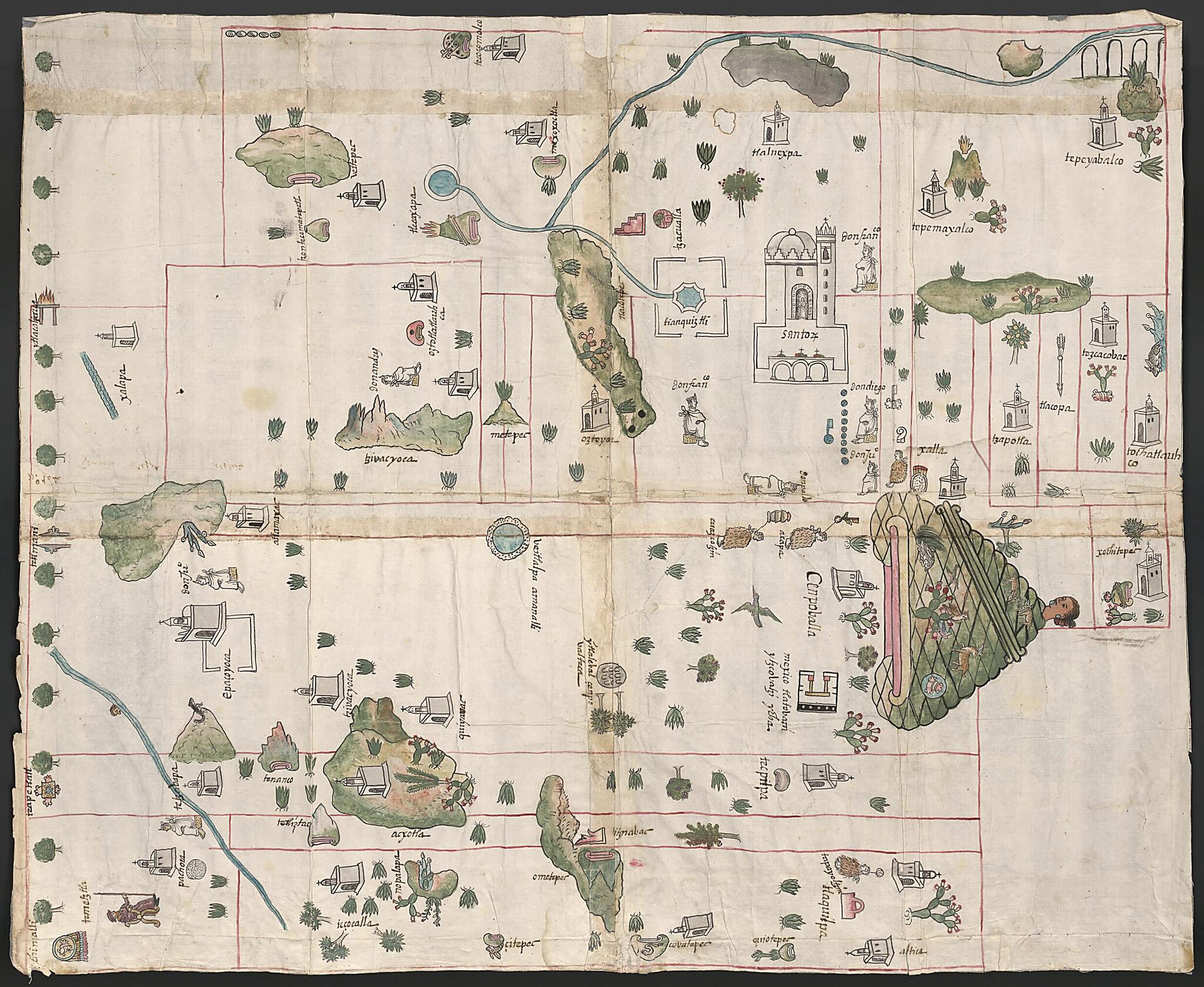
Cempoala, Mexico 1580
- Regular price
-
$124.95 - Regular price
-
$119.95 - Sale price
-
$124.95
Buy one map, get any other map in our collection for 50% OFF! Add to cart to see discount.
Couldn't load pickup availability
About This Map
Discover the timeless beauty of our fine art quality printed reproduction of this antique map. Perfect for history enthusiasts, collectors, and interior decorators.
Restored with meticulous attention to detail by our team with over a decade of experience, this stunning reproduction captures the intricate artistry and historical significance of the original map.
Whether you're a collector or seeking a unique decor piece, this archival-quality map reproduction is a timeless addition to any space. Order now to bring history to life!
Old map of Mexico, Veracruz, Zempoala.day state of Veracruz, Mexico, is from the Relaciones Geográficas collection in the Benson Latin American Collection at the University of Texas at Austin. Dating from between 1578 and 1586, the Relaciones Geográficas are responses to a questionnaire initiated by the Spanish crown in 1577, requesting information about Spanish-held territories in the Americas. The questionnaires covered such topics as demographics, political administration, languages spoken, physical terrain, and vegetation. The crown received 191 responses to these questionnaires. Of the 167 responses known to exist, 43 are in the Benson Latin American Collection. The others are held at the Archivo General de Indias, Seville, and the Real Academia de la Historia, Madrid. The relaciones contain important historical, cultural, and geographical information about New Spain during the 16th century. Many of the questionnaires are accompanied by maps and pictures. These both convey information about such topics as the colonial economy and the spread of European religion in New Spain and are artifacts for the study of the history of Latin American art and manuscript painting. This map, dated November 1, 1580, has glosses in Nahuatl, the language of the Aztecs.
- Title devised, in English, by Library staff.
- Original resource extent: 83 x 66 centimeters.
- Original resource at: University of Texas Libraries.
- Content in Eastern Huasteca Nahuatl.
- Description based on data extracted from World Digital Library, which may be extracted from partner institutions.
Map Subjects
Art Mexican
Aztec Art
Colonies
Indians Of Mexico
Indigenous Peoples
Manuscript Maps
Mesoamerica
Mexico
New Spain
Pictorial Maps
Spain
Veracruz
Zempoala
1580
- For the best legibility, order your map in the original size or larger. Most maps have intricate detail and small text that is best appreciated when the print size hasn't been reduced.
- Sizes labeled "Fits a Standard Frame" will drop right into any frame that you purchase in that size. The sizes that we offer are commonly available online and at most retail stores.
- Our standard sizes are recommendations based on the aspect ratio of the original map, but still may require some added "white space" in one dimension to fit.
- Non-standard sizes will require custom framing, and we suggest taking your print to the frame shop of your choice after you receive it for the best results.
- Custom sizes are available, simply contact us for a quote.
Below is an approximation of the scale of a few standard sizes, and how they might appear in your space.

