
Chart of North America From Boston to the Strait of Florida and Havana : In 4 Sheets in 1863
- Regular price
-
$318.95 - Regular price
-
$313.95 - Sale price
-
$318.95
Buy one map, get any other map in our collection for 50% OFF! Add to cart to see discount.
Couldn't load pickup availability
About This Map
Discover the timeless beauty of our fine art quality printed reproduction of this antique map. Perfect for history enthusiasts, collectors, and interior decorators.
Restored with meticulous attention to detail by our team with over a decade of experience, this stunning reproduction captures the intricate artistry and historical significance of the original map.
Whether you're a collector or seeking a unique decor piece, this archival-quality map reproduction is a timeless addition to any space. Order now to bring history to life!
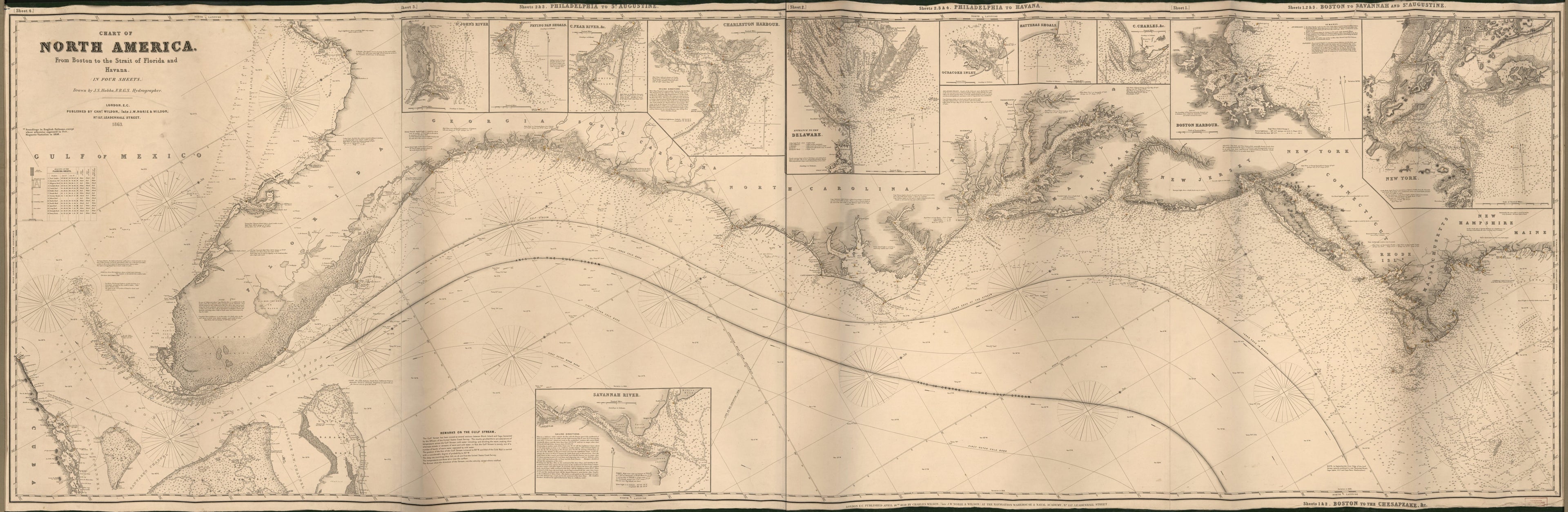
Old nautical chart of Atlantic Coast, Atlantic States, United States.Created by J. S. (John Stratton) Hobbs, Norie & Wilson, Charles William Wilson in 1863.
- Blue back coastal nautical chart extending from Havana to Richmond Island (Me.).
- Relief shown by hachures. Depths shown by contours and soundings.
- Hand col. to emphasize navigation beacons and markers (some with visibility circles).
- Also shows outlines and center line of the Gulf Stream.
- Principal title from segment marked "sheet 4" (left end).
- Oriented with north toward the upper right.
- Original 1859 publication note in lower margin: London E.C. Published April 16th 1859 by Charles Wilson (late J.W. Norie & Wilson) at the Navigation Warehouse & Naval Academy, no. 157 Leadenhall Street.
- Originally printed on 4 sheets (now conjoined as single sheet and cloth hemmed): Sheets 1 & 2. Boston to the Chesapeake &c. [title at bottom]. Sheets 1, 2 & 3. Boston to Savannah and St. Augustine [title at top] -- Sheets 2, 3 & 4. Philadelphia to Havana -- Sheets 2 & 3. Philadelphia to St. Augustine -- Sheet 4 [no sheet title].
- Includes text titled "Remarks on the Gulf Stream", notes, navigation beacon diagram, statistical table of the "Beacons of the Florida Reefs", and 11 regional insets (enlargements).
- For the best legibility, order your map in the original size or larger. Most maps have intricate detail and small text that is best appreciated when the print size hasn't been reduced.
- Sizes labeled "Fits a Standard Frame" will drop right into any frame that you purchase in that size. The sizes that we offer are commonly available online and at most retail stores.
- Our standard sizes are recommendations based on the aspect ratio of the original map, but still may require some added "white space" in one dimension to fit.
- Non-standard sizes will require custom framing, and we suggest taking your print to the frame shop of your choice after you receive it for the best results.
- Custom sizes are available, simply contact us for a quote.
Below is an approximation of the scale of a few standard sizes, and how they might appear in your space.
