
Chicago to San Franciso Via the Burlington Route 1879
- Regular price
-
$49.95 - Regular price
-
$34.95 - Sale price
-
$49.95
Buy one map, get any other map in our collection for 50% OFF! Add to cart to see discount.
Couldn't load pickup availability
About This Map
Discover the timeless beauty of our fine art quality printed reproduction of this antique map. Perfect for history enthusiasts, collectors, and interior decorators.
Restored with meticulous attention to detail by our team with over a decade of experience, this stunning reproduction captures the intricate artistry and historical significance of the original map.
Whether you're a collector or seeking a unique decor piece, this archival-quality map reproduction is a timeless addition to any space. Order now to bring history to life!
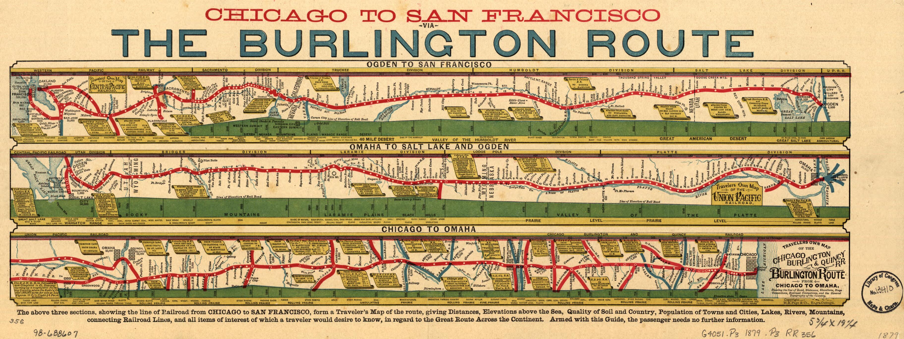
Old map of United States, West.Stylized, diagramatic strip map in three sections: Chicago to Omaha; Omaha; Omaha to Salt Lake and Ogden (via the Union Pacific); Ogden to San Francisco (via the Central Pacific)
Created by Burlington & Quincy Railroad Company Chicago, H.R. Page & Co in 1879.
- Scale ca. 1:3,000,000.
- Description derived from published bibliography.
- See entries 373-375.
- Contains profiles and elevation of lines, indicates geographic regions, industry and agriculture, mileage, stage connections, and railroads.
- "The above three sections, showing the line of railroad from Chicago to San Francisco giving distances, elevations above the sea, quality of soil and country, population of towns and cities, lakes, rivers, mountains, connecting railroad lines, and all items of interest of which a traveller would desire to know, in regard to the Great Route Across the continent. Armed with this Guide, the passenger needs to further information."
- For the best legibility, order your map in the original size or larger. Most maps have intricate detail and small text that is best appreciated when the print size hasn't been reduced.
- Sizes labeled "Fits a Standard Frame" will drop right into any frame that you purchase in that size. The sizes that we offer are commonly available online and at most retail stores.
- Our standard sizes are recommendations based on the aspect ratio of the original map, but still may require some added "white space" in one dimension to fit.
- Non-standard sizes will require custom framing, and we suggest taking your print to the frame shop of your choice after you receive it for the best results.
- Custom sizes are available, simply contact us for a quote.
Below is an approximation of the scale of a few standard sizes, and how they might appear in your space.
