
Chile, 1816. (Chili)
- Regular price
-
$79.95 - Regular price
-
$74.95 - Sale price
-
$79.95
Buy one map, get any other map in our collection for 50% OFF! Add to cart to see discount.
Couldn't load pickup availability
About This Map
Discover the timeless beauty of our fine art quality printed reproduction of this antique map. Perfect for history enthusiasts, collectors, and interior decorators.
Restored with meticulous attention to detail by our team with over a decade of experience, this stunning reproduction captures the intricate artistry and historical significance of the original map.
Whether you're a collector or seeking a unique decor piece, this archival-quality map reproduction is a timeless addition to any space. Order now to bring history to life!
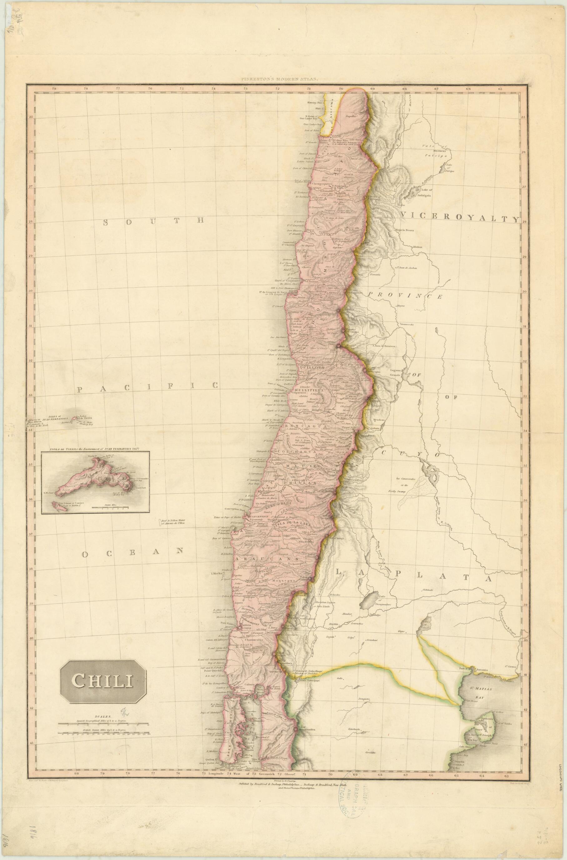
Old map of Argentina, Chile.colored map of 1816 shows most of Chile, from its northern border to approximately 44° South. Relief is shown by hachures. An inset map depicts Isola de Tierra, the easternmost of the Juan Fernández Islands, the archipelago in the Pacific Ocean that appears at the far western edge of the map. The map has two distance scales, Spanish geographical miles and British statute miles. Yellow is used to highlight the borders of the Viceroyalty of La Plata, an administrative unit of the Spanish Empire established in 1776 out of territories previously part of the Viceroyalty of Peru (comprising all or parts of present-day Argentina, Uruguay, Paraguay, and Bolivia). The map was included in Pinkerton's Modern Atlas, which was published in London between 1808 and 1815 and in a special American edition in 1818. John Pinkerton (1758-1826) was a Scottish scholar and author who wrote books on Scottish history and poetry, numismatics, and other topics. In 1808--14 he published the 17-volume A General Collection of the Best and Most Interesting Voyages and Travels in All Parts of the World. A six-volume edition of Pinkerton's compilation was issued in Philadelphia in 1810--12. The map was engraved by Samuel John Neele (1758--1824), who was from an important family of British engravers who worked from offices on the Strand in London.
Created by H. Charles, L. Hebert, Samuel John Neele, John Pinkerton in 1816.
- Title devised, in English, by Library staff.
- "Scale 1:3,000,000"--Note extracted from World Digital Library.
- Original resource extent: 1 map : hand colored, mounted on linen ; 70 x 50 centimeters.
- Original resource at: University of Wisconsin-Milwaukee Libraries.
- Content in English and Spanish.
- Description based on data extracted from World Digital Library, which may be extracted from partner institutions.
- For the best legibility, order your map in the original size or larger. Most maps have intricate detail and small text that is best appreciated when the print size hasn't been reduced.
- Sizes labeled "Fits a Standard Frame" will drop right into any frame that you purchase in that size. The sizes that we offer are commonly available online and at most retail stores.
- Our standard sizes are recommendations based on the aspect ratio of the original map, but still may require some added "white space" in one dimension to fit.
- Non-standard sizes will require custom framing, and we suggest taking your print to the frame shop of your choice after you receive it for the best results.
- Custom sizes are available, simply contact us for a quote.
Below is an approximation of the scale of a few standard sizes, and how they might appear in your space.

