
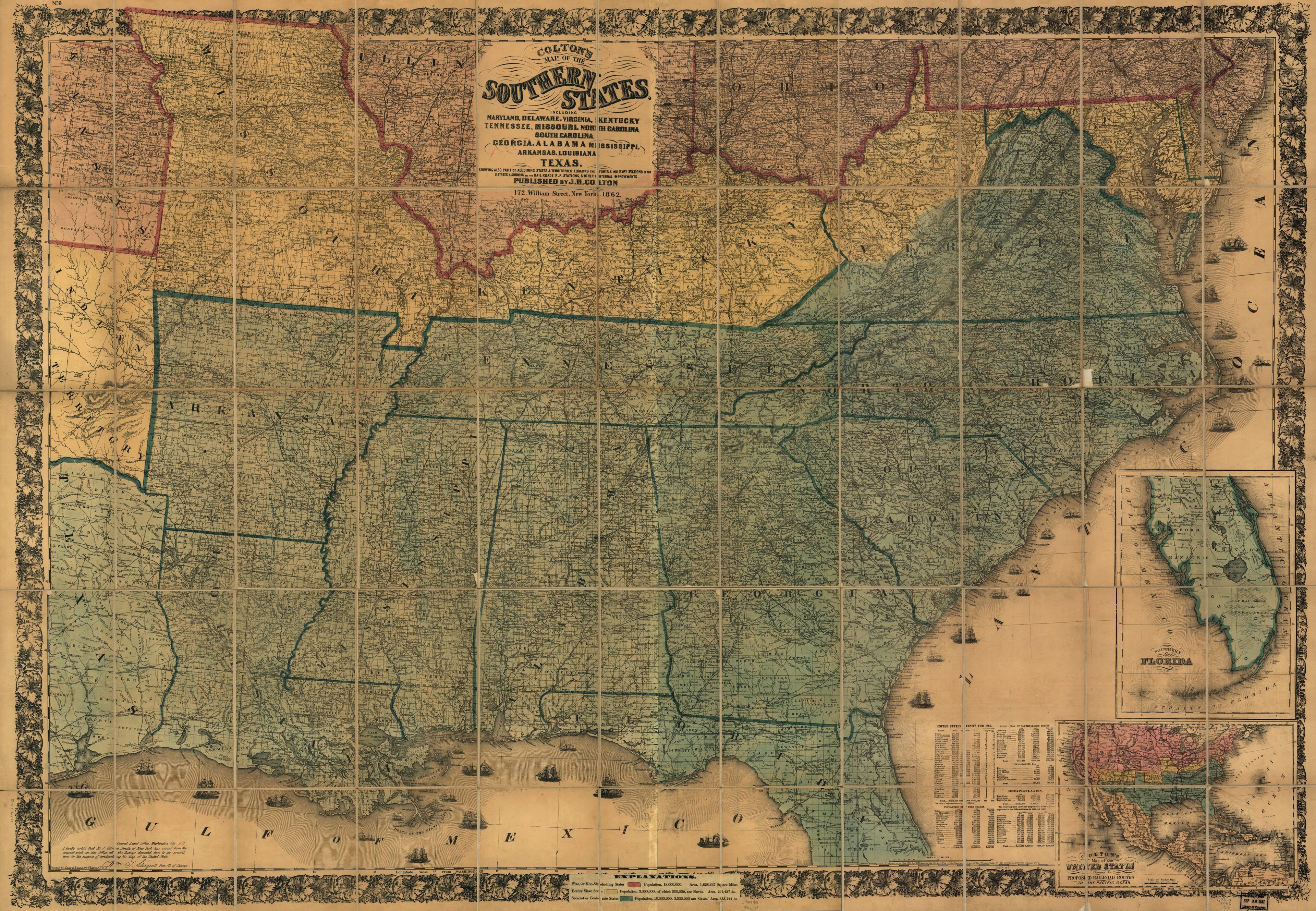
Colton's Map of the Southern States, Including Maryland, Delaware, Virginia, Kentucky, Tennessee, Missouri, North Carolina, South Carolina, Georgia, Alabama, Mississippi, Arkansas, Louisiana, Texas, Showing Also Part of Adjoining States & Territories ...
- Regular price
-
$214.95 - Regular price
-
$209.95 - Sale price
-
$214.95
Buy one map, get any other map in our collection for 50% OFF! Add to cart to see discount.
Couldn't load pickup availability
About This Map
Discover the timeless beauty of our fine art quality printed reproduction of this antique map. Perfect for history enthusiasts, collectors, and interior decorators.
Restored with meticulous attention to detail by our team with over a decade of experience, this stunning reproduction captures the intricate artistry and historical significance of the original map.
Whether you're a collector or seeking a unique decor piece, this archival-quality map reproduction is a timeless addition to any space. Order now to bring history to life!
Old map of Southern States, United States.Created by J. H. (Joseph Hutchins) Colton in 1862.
- Scale ca. 1: 1,520,640.
- Civil War Map
- "Entered according to Act of Congress in the year 1861 by J. H. Colton."
- Printed by Lang & Laing, N.Y.
- "No. 6" in the upper left margin.
- Insets: Southern part of Florida. 27 x 20 cm.-Colton's map of the United States showing the proposed railroad routes to the Pacific Ocean. 19 x 26 cm.
- Includes tables of population based on the "United States Census for 1860."
- Cover title: Colton's map of the southern states of America, showing the whole seat of war on the seabord [sic] and in the interior, designating every town, railway, and stream; also showing the forts and fortifications. London, Bacon and Co.
- Pasted inside the cover is a list of "Bacon's shilling series of American war maps, just published."
- Advertisement for "Bacon's guide to American politics" and a list of "Colton's maps of America, and complete series of war maps" are pasted to the verso of the map.
- "Explanations" (i.e., legend) is pasted over the bottom border. Map is colored to show "free, or non-slaveholding states" (pink), "border slave states" (yellow), and "seceded or confederate states" (green).
- 1861 editions are listed as Civil War Maps entry nos. 6.5-6.6; 1863 edition is listed as Civil War Maps entry no. 37.6.
- Description derived from published bibliography.
- For the best legibility, order your map in the original size or larger. Most maps have intricate detail and small text that is best appreciated when the print size hasn't been reduced.
- Sizes labeled "Fits a Standard Frame" will drop right into any frame that you purchase in that size. The sizes that we offer are commonly available online and at most retail stores.
- Our standard sizes are recommendations based on the aspect ratio of the original map, but still may require some added "white space" in one dimension to fit.
- Non-standard sizes will require custom framing, and we suggest taking your print to the frame shop of your choice after you receive it for the best results.
- Custom sizes are available, simply contact us for a quote.
Below is an approximation of the scale of a few standard sizes, and how they might appear in your space.
