
Colton's Persia, Arabia, Et Cetera. (Colton's Persia, Arabia, &c) 1865
- Regular price
-
$54.95 - Regular price
-
$49.95 - Sale price
-
$54.95
Buy one map, get any other map in our collection for 50% OFF! Add to cart to see discount.
Couldn't load pickup availability
About This Map
Discover the timeless beauty of our fine art quality printed reproduction of this antique map. Perfect for history enthusiasts, collectors, and interior decorators.
Restored with meticulous attention to detail by our team with over a decade of experience, this stunning reproduction captures the intricate artistry and historical significance of the original map.
Whether you're a collector or seeking a unique decor piece, this archival-quality map reproduction is a timeless addition to any space. Order now to bring history to life!
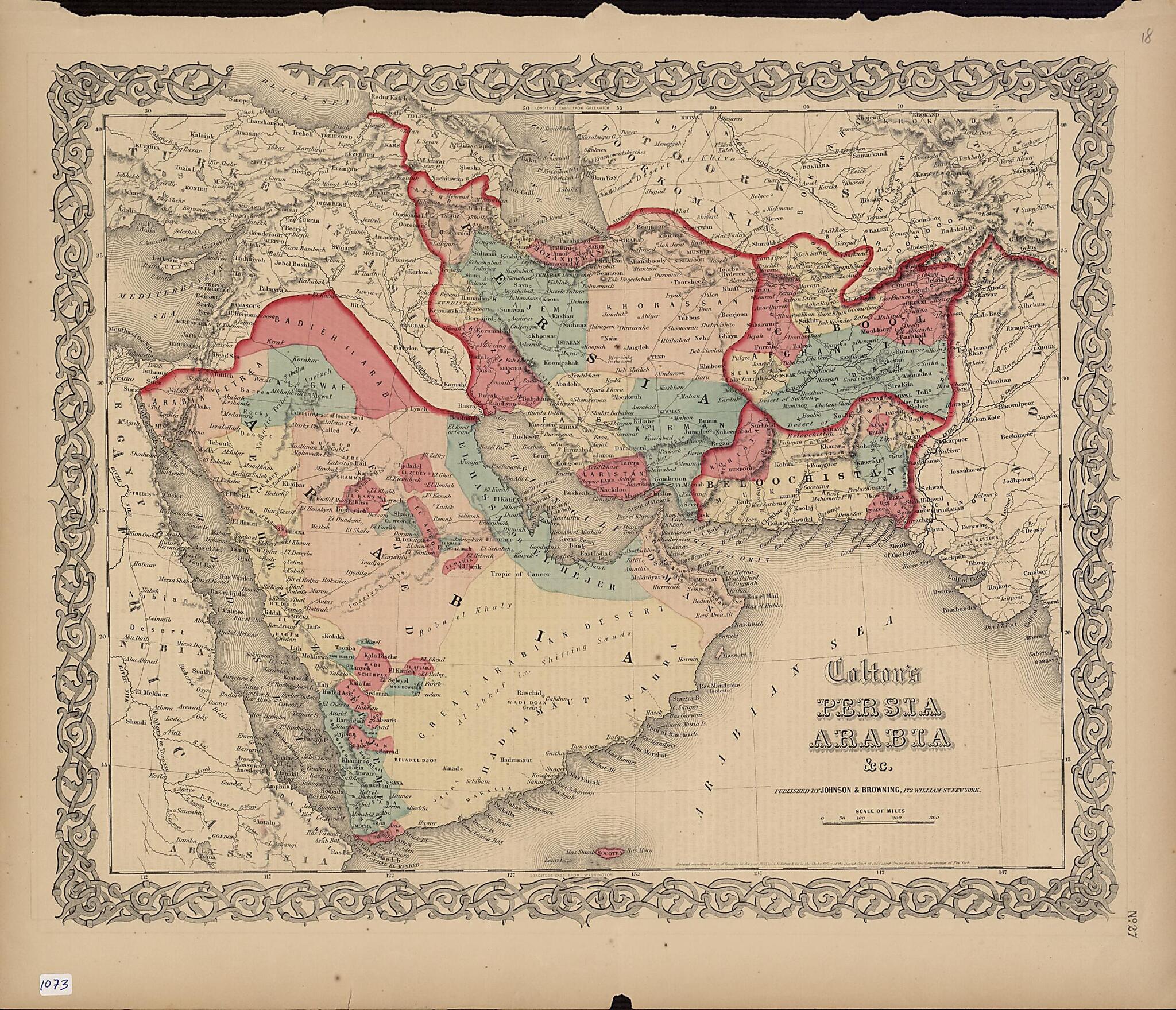
Old map of Afghanistan, Armenia, Azerbaijan, Bahrain, Cyprus, Egypt, Eritrea, Iran, Islamic Republic of, Iraq, Israel, Jordan, Kuwait, Lebanon, Oman, Pakistan, Qatar, Sudan, Syrian Arab Republic, Tajikistan, Turkey, Turkmenistan, United Arab Emirates, Uzbekistan, Yemen.day Iran), Afghanistan, Baluchistan (present-day Iran and Pakistan), and adjacent territories was copyrighted in 1855 by J.H. Colton & Company of New York. Coloring is used to indicate borders and certain provinces or settled areas. The map shows cities, mountains, and roads, and includes some notes on topographical features. The old Qatari city of al-Zabarah is shown. The map appeared in other editions of Colton's General Atlas and reflects the general level of geographic knowledge of the Middle East in mid-19th-century America. Supplementing the map is a one-page political and social description of Persia and its history and geography. It augments other Colton maps found in the World Digital Library covering the same region. J.H. Colton & Company was founded in New York City, most likely in 1831, by Joseph Hutchins Colton (1800--93), a Massachusetts native who had only a basic education and little or no formal training in geography or cartography. He built the firm into a major publisher of maps and atlases by purchasing the copyrights to other maps and republishing them before it began creating its own maps and atlases. In the 1850s, the firm became the G.W. & C.B. Colton Company, after Colton brought his sons, George Woolworth Colton (1827--1901) and Charles B. Colton (1832--1916), into the business. As in this example, virtually all Colton maps were framed by decorative borders of intertwining vines, flowers, or geometric shapes. The work was entered according to Act of Congress in the year 1855 in the United States District Court of the Southern District of New York and published by Johnson and Browning of New York City, sometimes a collaborator, sometimes a competitor of the Colton firm.
Created by G. Woolworth (George Woolworth) Colton, J.H. Colton & Company in 1865.
- Title devised, in English, by Library staff.
- Original resource extent: 1 map : color ; 31 x 36 centimeters.
- Original resource at: Qatar National Library.
- Content in English.
- Description based on data extracted from World Digital Library, which may be extracted from partner institutions.
Map Subjects
Afghanistan
Arabian Gulf
Arabian Peninsula
Armenia
Azerbaijan
Bahrain
Cyprus
Egypt
Eritrea
Iran Islamic Republic Of
Iraq
Israel
Jordan
Kuwait
Lebanon
Oman
Pakistan
Persian Gulf
Qatar
Red Sea
Sudan
Syrian Arab Republic
Tajikistan
Turkey
Turkmenistan
United Arab Emirates
Uzbekistan
Yemen
G. Woolworth (George Woolworth) Colton
J.H. Colton & Company
1865
- For the best legibility, order your map in the original size or larger. Most maps have intricate detail and small text that is best appreciated when the print size hasn't been reduced.
- Sizes labeled "Fits a Standard Frame" will drop right into any frame that you purchase in that size. The sizes that we offer are commonly available online and at most retail stores.
- Our standard sizes are recommendations based on the aspect ratio of the original map, but still may require some added "white space" in one dimension to fit.
- Non-standard sizes will require custom framing, and we suggest taking your print to the frame shop of your choice after you receive it for the best results.
- Custom sizes are available, simply contact us for a quote.
Below is an approximation of the scale of a few standard sizes, and how they might appear in your space.

