
Colton's Peru and Bolivia 1855
- Regular price
-
$61.95 - Regular price
-
$43.95 - Sale price
-
$61.95
Buy one map, get any other map in our collection for 50% OFF! Add to cart to see discount.
Couldn't load pickup availability
About This Map
Discover the timeless beauty of our fine art quality printed reproduction of this antique map. Perfect for history enthusiasts, collectors, and interior decorators.
Restored with meticulous attention to detail by our team with over a decade of experience, this stunning reproduction captures the intricate artistry and historical significance of the original map.
Whether you're a collector or seeking a unique decor piece, this archival-quality map reproduction is a timeless addition to any space. Order now to bring history to life!
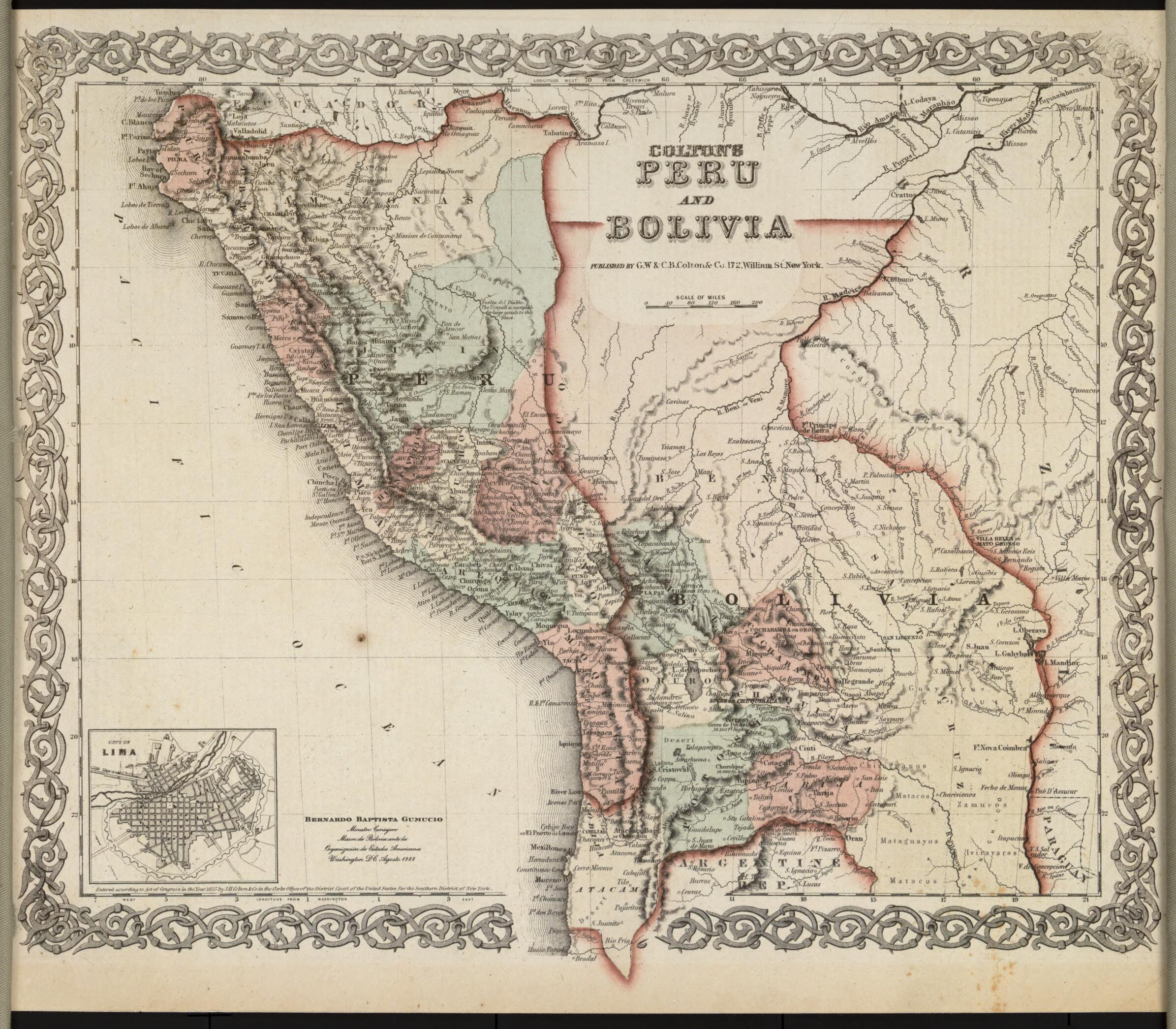
Old map of Bolivia, Chile, Peru.left-hand corner. In the upper right are the River Madeira, forming part of the border between Peru and Brazil, and the Amazon, the upper parts of which are known in Peru as the Marañón and in Brazil as the Solimões. A note indicates the navigability of the River Ucayali up to the Vuelta del Diablo (Devil's Bend). Atacama, a disputed territory that was transferred to Chile after the 1879--83 War of the Pacific, is shown as part of Bolivia. The map originally appeared in Colton's 1855 Atlas of the World. J.H. Colton & Company was founded in New York City, most likely in 1831, by Joseph Hutchins Colton (1800--93), a Massachusetts native who had only a basic education and little or no formal training in geography or cartography. Colton built the firm into a major publisher of maps and atlases by purchasing the copyrights to and republishing other maps. In the 1850s, the firm became G.W. & C.B. Colton & Company, after Colton brought his sons, George Woolworth Colton (1827--1901) and Charles B. Colton (1832--1916), into the business. As in this example, virtually all Colton maps were framed in decorative borders of intertwining vines, flowers, or geometric shapes.
- Title devised, in English, by Library staff.
- "Scale around 1:7,900,000"--Note extracted from World Digital Library.
- Original resource extent: 2 maps on 1 sheet : facsimile, color ; 33 x 40 centimeters.
- Original resource at: Columbus Memorial Library, Organization of American States.
- Content in English.
- Description based on data extracted from World Digital Library, which may be extracted from partner institutions.
- For the best legibility, order your map in the original size or larger. Most maps have intricate detail and small text that is best appreciated when the print size hasn't been reduced.
- Sizes labeled "Fits a Standard Frame" will drop right into any frame that you purchase in that size. The sizes that we offer are commonly available online and at most retail stores.
- Our standard sizes are recommendations based on the aspect ratio of the original map, but still may require some added "white space" in one dimension to fit.
- Non-standard sizes will require custom framing, and we suggest taking your print to the frame shop of your choice after you receive it for the best results.
- Custom sizes are available, simply contact us for a quote.
Below is an approximation of the scale of a few standard sizes, and how they might appear in your space.

