
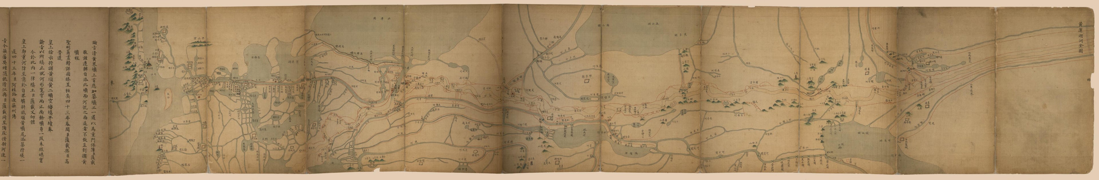
黃,運,湖,河全圖 /, Complete Map of the Yellow River, the Grand Canal, Hongze Lake, and the Huai River in 1777
- Regular price
-
$67.95 - Regular price
-
$62.95 - Sale price
-
$67.95
Shipping calculated at checkout.
Buy one map, get any other map in our collection for 50% OFF! Add to cart to see discount.
Couldn't load pickup availability
About This Map
Old map of China, Grand Canal, Yellow River.
Created by Jin Gao, Arthur W. (Arthur William) Hummel, Sazai in 1777.
Created by Jin Gao, Arthur W. (Arthur William) Hummel, Sazai in 1777.
- Scale ca. 1:400,000.
- Manuscript on silk mounted on paper.
- Oriented with north to the right.
- Relief shown pictorially.
- Pictorial map.
- Shows the dike system of the Yellow River and the Grand Canal in Shandong Province to the Yangtze River in Jiangsu Province.
- Includes text.
- Insets: Yi jian dong xi ba tu -- Taozhuang Xinhe bing lan Huangshun Huangba tu -- Wucheng san bao tu -- Haikou bing er tao tu.
- Purchase; Arthur William Hummel; 1930, no. 14.
- Previous call number: G7822.Y4N22 1785 .S3 Vault Shelf
Map Sizing Information
- For the best legibility, order your map in the original size or larger. Most maps have intricate detail and small text that is best appreciated when the print size hasn't been reduced.
- Sizes labeled "Fits a Standard Frame" will drop right into any frame that you purchase in that size. The sizes that we offer are commonly available online and at most retail stores.
- Our standard sizes are recommendations based on the aspect ratio of the original map, but still may require some added "white space" in one dimension to fit.
- Non-standard sizes will require custom framing, and we suggest taking your print to the frame shop of your choice after you receive it for the best results.
- Custom sizes are available, simply contact us for a quote.
Below is an approximation of the scale of a few standard sizes, and how they might appear in your space.
