
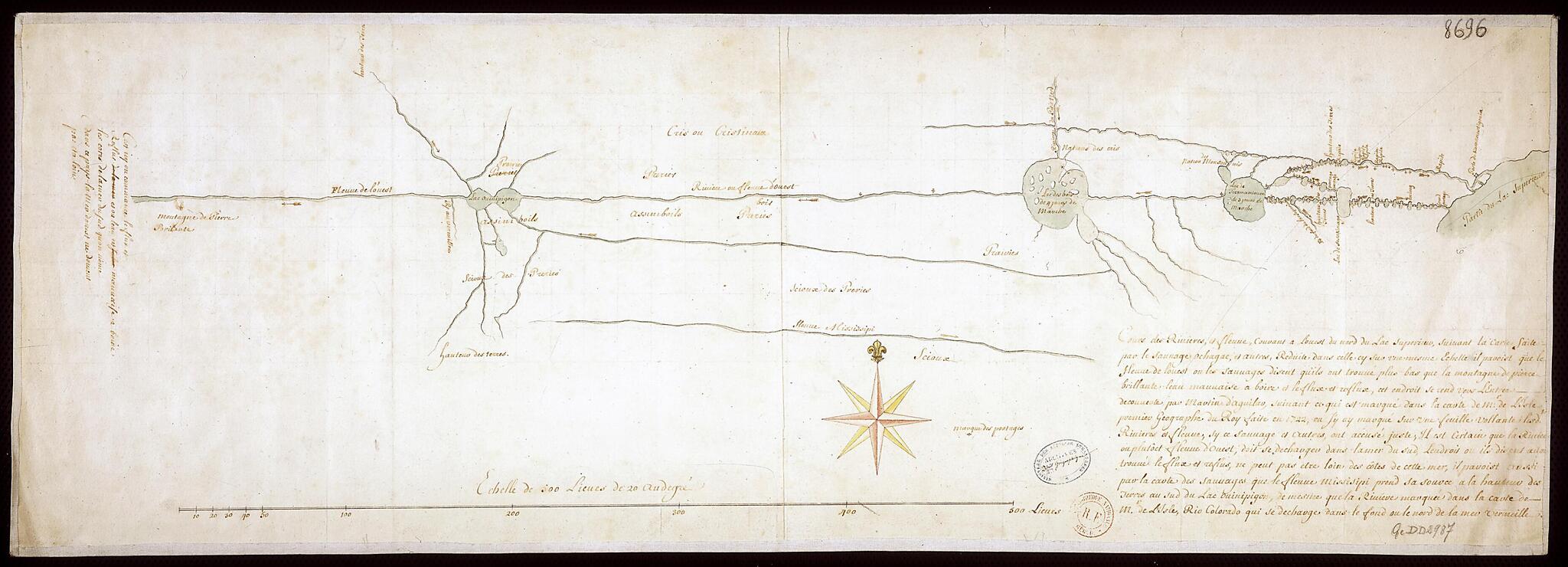
Course of the Rivers and Streams Flowing to the West from the North of Lake Superior. (Cours Des Rivières, Et Fleuves, Courant à L'ouest Du Nord Du Lac Supérieur) 1722
- Regular price
-
$49.95 - Regular price
-
$34.95 - Sale price
-
$49.95
Buy one map, get any other map in our collection for 50% OFF! Add to cart to see discount.
Couldn't load pickup availability
About This Map
Discover the timeless beauty of our fine art quality printed reproduction of this antique map. Perfect for history enthusiasts, collectors, and interior decorators.
Restored with meticulous attention to detail by our team with over a decade of experience, this stunning reproduction captures the intricate artistry and historical significance of the original map.
Whether you're a collector or seeking a unique decor piece, this archival-quality map reproduction is a timeless addition to any space. Order now to bring history to life!
Old map of Canada, Manitoba, Ontario.-1749), presented to the governor of Canada, Charles de la Boische, Marquis de Beauharnois, a plan to find the Western Sea, based upon information provided by Ochagac (also seen as Auchagah, a Cree from around Fort Kaministiquia). In 1731, La Vérendrye obtained a concession for the fur trade monopoly in the lands of the Sioux to finance his expeditions. From 1731 to 1744 La Vérendrye and three of his sons, Jean-Baptiste, Pierre, and François, searched for the Western Sea by way of the Great Lakes. Although he did not find the Western Sea, La Vérendrye explored the region from Fort Kaministiquia (north of Lake Superior) to Lakes Winnipeg and Manitoba and the White River (Saskatchewan) and created a series of trading posts, including Fort Maurepas (on the Red River) in 1734 and Fort La Reine (at present-day Portage La Prairie) in 1738.
Created by Guillaume De L'isle, Flourished 18th Century Ochagac in 1722.
- Title devised, in English, by Library staff.
- "Scale about 1:5,000,000"--Note extracted from World Digital Library.
- Original resource extent: 1 map : manuscript ; 33.5 x 100 centimeters.
- Reference extracted from World Digital Library: K.R. Macpherson, "AUCHAGAH," in Dictionary of Canadian Biography 2 (Toronto: University of Toronto/Université Laval, 2003-- ).|Yves F. Zoltvany "GAULTIER DE VARENNES ET DE LA VÉRENDRYE, PIERRE" in Dictionary of Canadian Biography 3 (Toronto: University of Toronto/Université Laval, 2003-- ).
- Original resource at: National Library of France.
- Content in French.
- Description based on data extracted from World Digital Library, which may be extracted from partner institutions.
Map Subjects
Canada
Exploration And Encounters
Indians Of North America
Indigenous Peoples
Manitoba
Manuscript Maps
Ontario
River Of The West (Mythical Body Of Water)
Superior Lake
Guillaume De L'isle
Flourished 18th Century Ochagac
1722
- For the best legibility, order your map in the original size or larger. Most maps have intricate detail and small text that is best appreciated when the print size hasn't been reduced.
- Sizes labeled "Fits a Standard Frame" will drop right into any frame that you purchase in that size. The sizes that we offer are commonly available online and at most retail stores.
- Our standard sizes are recommendations based on the aspect ratio of the original map, but still may require some added "white space" in one dimension to fit.
- Non-standard sizes will require custom framing, and we suggest taking your print to the frame shop of your choice after you receive it for the best results.
- Custom sizes are available, simply contact us for a quote.
Below is an approximation of the scale of a few standard sizes, and how they might appear in your space.
