
Da Qing Yi Tong Tian Xia Quan Tu (大清一統天下全圖) 1818
- Regular price
-
$124.95 - Regular price
-
$119.95 - Sale price
-
$124.95
Buy one map, get any other map in our collection for 50% OFF! Add to cart to see discount.
Couldn't load pickup availability
About This Map
Discover the timeless beauty of our fine art quality printed reproduction of this antique map. Perfect for history enthusiasts, collectors, and interior decorators.
Restored with meticulous attention to detail by our team with over a decade of experience, this stunning reproduction captures the intricate artistry and historical significance of the original map.
Whether you're a collector or seeking a unique decor piece, this archival-quality map reproduction is a timeless addition to any space. Order now to bring history to life!
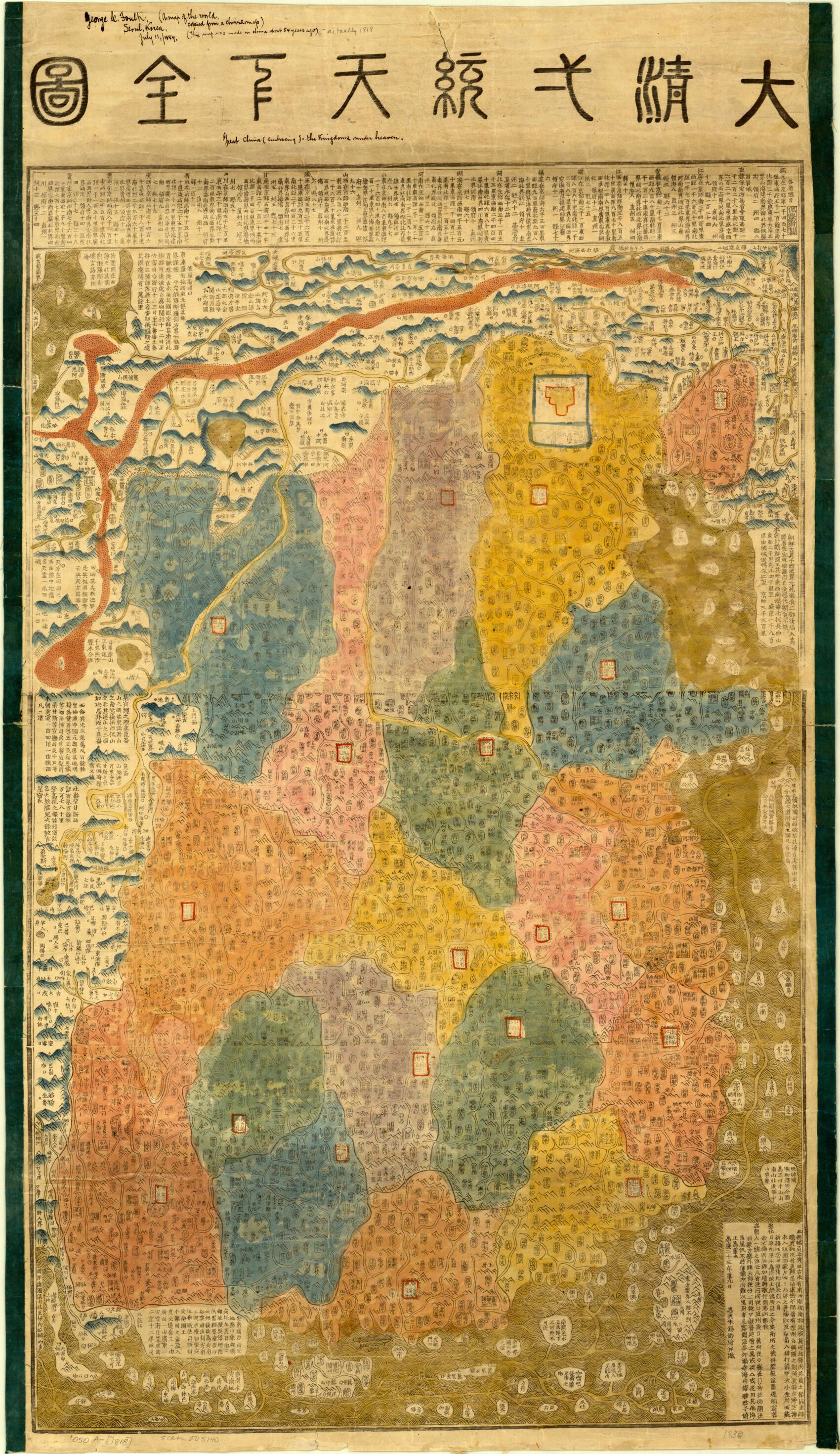
colored wood-block print, first published in Beijing by Zhu Xiling. China is at the center of the map, which shows the Great Wall, Lop Nur Desert, provincial divisions, provincial and regional capitals, military outposts, local settlements, and the main waterways and rivers. Hainan, Taiwan, Java Island, Brunei, Johore, Vietnam, and Cambodia are delineated. America and other Western countries are represented as an array of amorphous and inconsequential islands bordering the main landmass. The map also shows "Eluosi guo," or "Russia Country;" "Yingjili guo jie," or "England Border;" and "Helan guo," or "Holland Country." The Indian Ocean is described as the "Small Western Ocean." The map was given to the American Geographical Society of New York in 1884 by George C. Foulk and bears his annotations.Created by Xiling Zhu in 1818.
- Title devised, in English, by Library staff.
- Original resource extent: 1 map : hand colored, annotated ; 107 x 62 centimeters.
- Original resource at: University of Wisconsin-Milwaukee Libraries.
- Content in Chinese.
- Description based on data extracted from World Digital Library, which may be extracted from partner institutions.
- Title revised per Asian Division.--cc28 2023-01-06
- For the best legibility, order your map in the original size or larger. Most maps have intricate detail and small text that is best appreciated when the print size hasn't been reduced.
- Sizes labeled "Fits a Standard Frame" will drop right into any frame that you purchase in that size. The sizes that we offer are commonly available online and at most retail stores.
- Our standard sizes are recommendations based on the aspect ratio of the original map, but still may require some added "white space" in one dimension to fit.
- Non-standard sizes will require custom framing, and we suggest taking your print to the frame shop of your choice after you receive it for the best results.
- Custom sizes are available, simply contact us for a quote.
Below is an approximation of the scale of a few standard sizes, and how they might appear in your space.

