
The Holy and Expanded City of Jerusalem, First Known As Salem. (De Heylige En Wytvermaerde Stadt Ierusalem, Eerst Genaemt Salem) 1756
- Regular price
-
$54.95 - Regular price
-
$49.95 - Sale price
-
$54.95
Buy one map, get any other map in our collection for 50% OFF! Add to cart to see discount.
Couldn't load pickup availability
About This Map
Discover the timeless beauty of our fine art quality printed reproduction of this antique map. Perfect for history enthusiasts, collectors, and interior decorators.
Restored with meticulous attention to detail by our team with over a decade of experience, this stunning reproduction captures the intricate artistry and historical significance of the original map.
Whether you're a collector or seeking a unique decor piece, this archival-quality map reproduction is a timeless addition to any space. Order now to bring history to life!
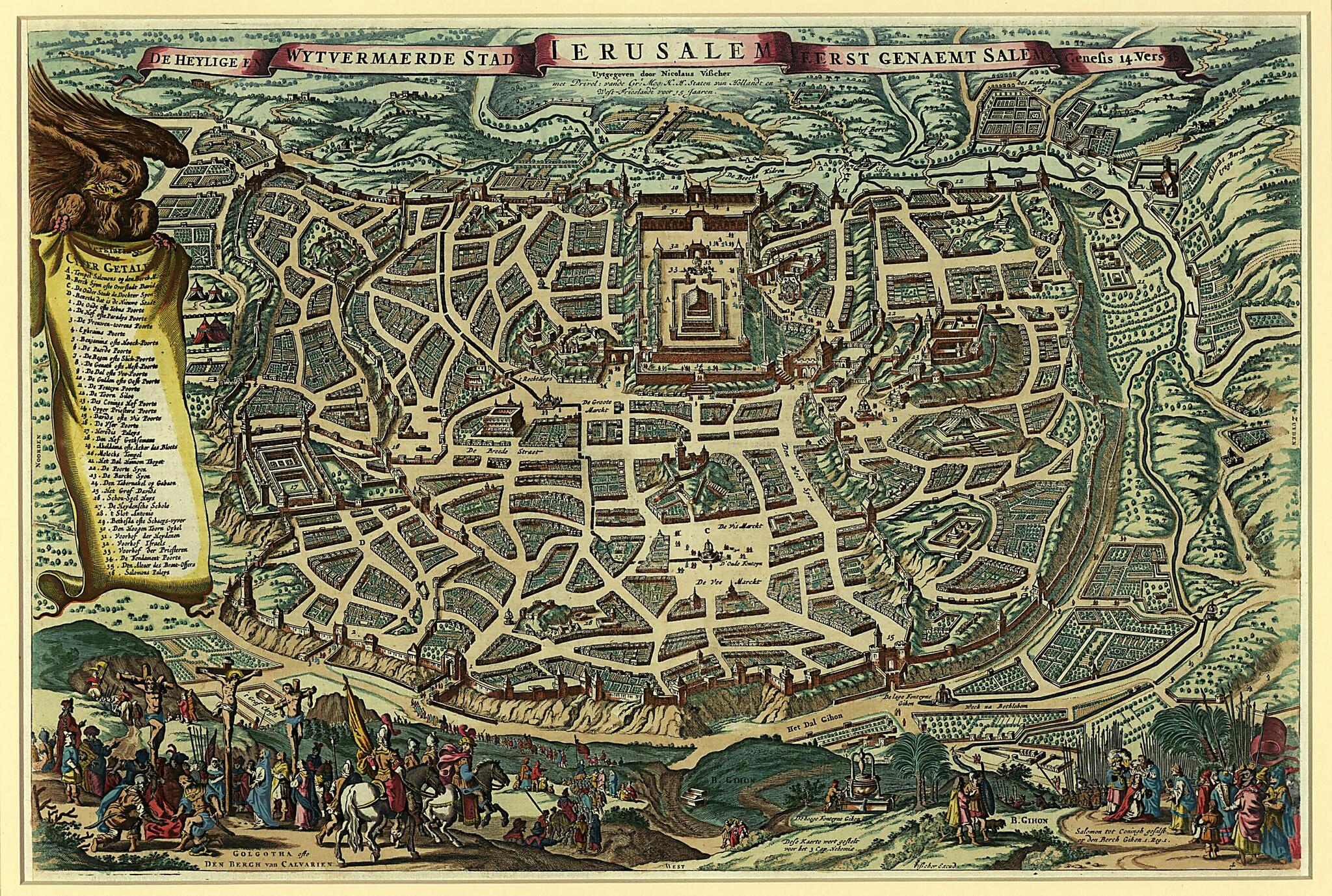
Old map of Israel, Jerusalem.1652). It offers an imaginary, detailed bird's-eye view of the city, with 36 important locations from the Bible identified by name on a scrollwork legend held up by an eagle. The sites include Solomon's Temple (upper center), the walls and gates of the city, the crucifixion at Golgotha, or Calvary (bottom left), Berch Gihon, where King Solomon was anointed by Zadok the priest (bottom right), and Herod's Palace (far left). North is oriented towards the left. The inscription near the base in the center explains that the map was to appear in a Bible before the book of Nehemiah, Chapter 3. The title scroll at top links this image to Genesis, Chapter 14, Verse 18. The map is derived from a similar map by Johann and Henricus Stern, created in 1630. Visscher, his son Nicolaes, and his grandson Nicolaes II were important art and map dealers in Amsterdam for about 100 years, beginning in the early 17th century. The Visschers worked primarily as art dealers, but they were also publishers who produced individual maps and compiled atlases to order. Their works are noteworthy for their fine engraving, the accuracy of the maps, and the beautiful illustrations. Two of the leading artists who worked on Visscher maps were Abraham van den Broeck (1616-88) and Nicolaes Berchem (1620-83). This map was long one of the most popular views of Jerusalem to circulate in Europe.
Created by Claes Jansz Visscher in 1756.
- Title devised, in English, by Library staff.
- Original resource extent: 1 map : color ; 40 x 49 centimeters.
- Original resource at: Qatar National Library.
- Content in Dutch.
- Description based on data extracted from World Digital Library, which may be extracted from partner institutions.
Map Subjects
Aerial Views
Bible
Bible. New Testament
Bible. Old Testament
Churches
Cities And Towns
City Walls
Crucifixion Of The Christ
Fantasy In Art
Geography
Israel
Jerusalem
Jesus Christ
Solomon King Of Israel
Temple Mount (Jerusalem)
Temples
To 33
Claes Jansz Visscher
1756
- For the best legibility, order your map in the original size or larger. Most maps have intricate detail and small text that is best appreciated when the print size hasn't been reduced.
- Sizes labeled "Fits a Standard Frame" will drop right into any frame that you purchase in that size. The sizes that we offer are commonly available online and at most retail stores.
- Our standard sizes are recommendations based on the aspect ratio of the original map, but still may require some added "white space" in one dimension to fit.
- Non-standard sizes will require custom framing, and we suggest taking your print to the frame shop of your choice after you receive it for the best results.
- Custom sizes are available, simply contact us for a quote.
Below is an approximation of the scale of a few standard sizes, and how they might appear in your space.
