
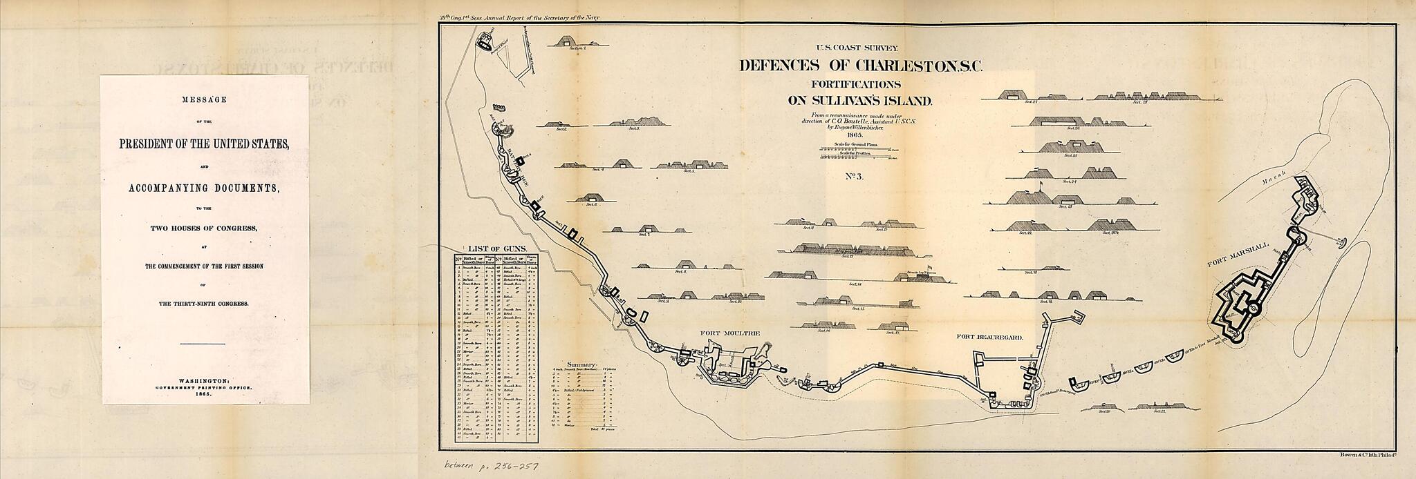
Defences of Charleston S.C. Fortifications On Sullivan's Island 1865
- Regular price
-
$53.95 - Regular price
-
$48.95 - Sale price
-
$53.95
Buy one map, get any other map in our collection for 50% OFF! Add to cart to see discount.
Couldn't load pickup availability
About This Map
Discover the timeless beauty of our fine art quality printed reproduction of this antique map. Perfect for history enthusiasts, collectors, and interior decorators.
Restored with meticulous attention to detail by our team with over a decade of experience, this stunning reproduction captures the intricate artistry and historical significance of the original map.
Whether you're a collector or seeking a unique decor piece, this archival-quality map reproduction is a timeless addition to any space. Order now to bring history to life!
Old map of South Carolina, Sullivan Island, United States.- Scale ca. 1:4000.
- Civil War Map
- From Message of the President of the United States, and accompanying documents, to the two houses of Congress, at the commencement of the first session of the thirty-ninth Congress.-Report of the Secretary of the Navy (Washington, Government Printing Office, 1865). fol. p. 256.
- At head of title: U.S. Coast Survey.
- "No. 3" is printed below the map title and bar scales.
- Printed in upper left margin: 39th Cong. 1st sess.-Annual Report of the Secretary of the Navy.
- Map shows Battery Bee and forts Moultrie, Beauregard, and Marshall. Included are 21 profiles of the defensive works. A "List of guns" appears in the lower left corner.
- Description derived from published bibliography.
Map Subjects
Fortification
South Carolina
Sullivan Island
United States
1865
- For the best legibility, order your map in the original size or larger. Most maps have intricate detail and small text that is best appreciated when the print size hasn't been reduced.
- Sizes labeled "Fits a Standard Frame" will drop right into any frame that you purchase in that size. The sizes that we offer are commonly available online and at most retail stores.
- Our standard sizes are recommendations based on the aspect ratio of the original map, but still may require some added "white space" in one dimension to fit.
- Non-standard sizes will require custom framing, and we suggest taking your print to the frame shop of your choice after you receive it for the best results.
- Custom sizes are available, simply contact us for a quote.
Below is an approximation of the scale of a few standard sizes, and how they might appear in your space.
