
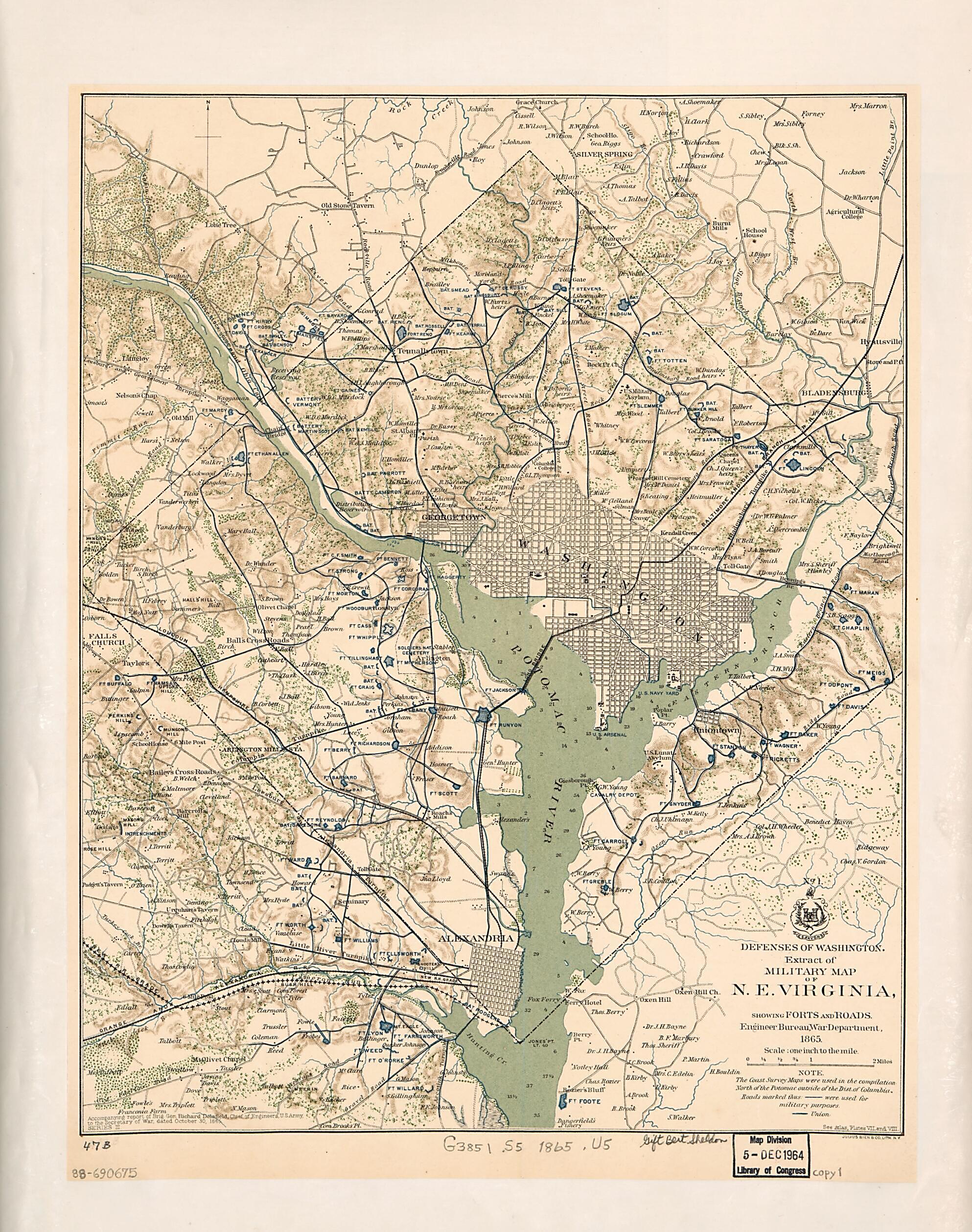
Defenses of Washington, Extract of Military Map of N.E. Virginia : Showing Forts and Roads 1865
- Regular price
-
$54.95 - Regular price
-
$31.95 - Sale price
-
$54.95
Buy one map, get any other map in our collection for 50% OFF! Add to cart to see discount.
Couldn't load pickup availability
About This Map
Discover the timeless beauty of our fine art quality printed reproduction of this antique map. Perfect for history enthusiasts, collectors, and interior decorators.
Restored with meticulous attention to detail by our team with over a decade of experience, this stunning reproduction captures the intricate artistry and historical significance of the original map.
Whether you're a collector or seeking a unique decor piece, this archival-quality map reproduction is a timeless addition to any space. Order now to bring history to life!
Old map of District of Columbia, United States, Washington, Washington D.C., Washington Metropolitan Area.Created by Richard Delafield, United States. Government Printing Office, United States. War Department. Engineer Bureau in 1865.
- Relief shown by hachures. Depths shown by soundings.
- Also shows woods and householders' names in rural areas.
- In lower left corner: Accompanying report of Brig. Gen. Richard Delafield ... dated October 30, 1865, series III.
- From: Atlas to accompany the official records of the Union and Confederate Armies, Washington, 1891-1895, plate 89, map 1.
- In lower right corner: See Atlas, Plates VII. and VIII.
- Includes note and coat of arms.
- At head of coat of arms: No. 1.
- 3 copies
Map Subjects
Civil War
District Of Columbia
Fortification
History
Real Property
United States
Washington
Washington (D.C.)
Washington Metropolitan Area
Washington D.C.
Richard Delafield
United States. Government Printing Office
United States. War Department. Engineer Bureau
1865
- For the best legibility, order your map in the original size or larger. Most maps have intricate detail and small text that is best appreciated when the print size hasn't been reduced.
- Sizes labeled "Fits a Standard Frame" will drop right into any frame that you purchase in that size. The sizes that we offer are commonly available online and at most retail stores.
- Our standard sizes are recommendations based on the aspect ratio of the original map, but still may require some added "white space" in one dimension to fit.
- Non-standard sizes will require custom framing, and we suggest taking your print to the frame shop of your choice after you receive it for the best results.
- Custom sizes are available, simply contact us for a quote.
Below is an approximation of the scale of a few standard sizes, and how they might appear in your space.

