
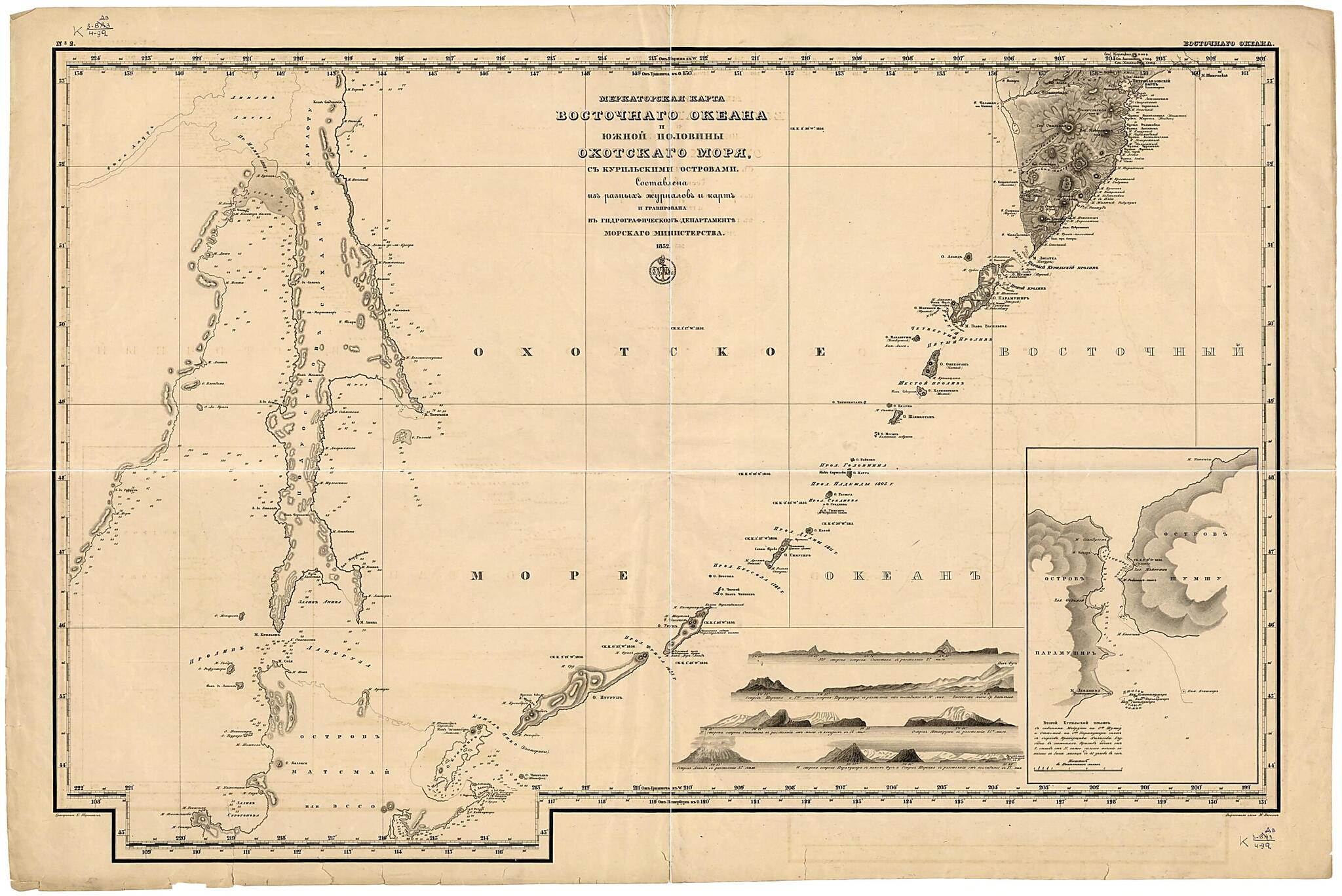
Merkatorskai︠a︡ Karta Vostochnogo Okeana I I︠u︡zhnoĭ Poloviny Okhotskogo Mori︠a︡ S Kuril'skimi Ostrovami. (Меркаторская карта Восточного океана и южной половины Охотского моря с...
- Regular price
-
$111.95 - Regular price
-
$106.95 - Sale price
-
$111.95
Buy one map, get any other map in our collection for 50% OFF! Add to cart to see discount.
Couldn't load pickup availability
About This Map
Discover the timeless beauty of our fine art quality printed reproduction of this antique map. Perfect for history enthusiasts, collectors, and interior decorators.
Restored with meticulous attention to detail by our team with over a decade of experience, this stunning reproduction captures the intricate artistry and historical significance of the original map.
Whether you're a collector or seeking a unique decor piece, this archival-quality map reproduction is a timeless addition to any space. Order now to bring history to life!
Old map of Russian Federation.Created by Gidrograficheskiĭ Departament Morskogo Ministerstva, E. Terent'ev in 1852.
- Sostavlena iz raznykh zhurnalov i kart. Kartograficheskai︠a︡ setka po dolgote cherez 4°, po shirote - cherez 3°, vykhody koordinat cherez 30'; schet dolgot ot Grinvicha, Pulkova. Dop.karta: Vtoroĭ Kuril'skiĭ proliv. Tekst: S gavani︠a︡mi Maĭruppo na o-vakh Shumshu i Otomaĭ n.
- Pokazany: rel'ef shtrikhami s nazvanii︠a︡mi otdel'nykh gor, otmetki glubin v sazheni︠a︡kh, meli, rify, podvodnye i nadvodnye kamni, magnitnye sklonenii︠a︡, azimuty otdel'nykh napravleniĭ; naselennye punkty (na Kamchatke). Risunki: vidy ostrovov s razlichnykh storon, s rass.
- Original map at: National Library of Russia
- Составлена из разных журналов и карт. Картографическая сетка по долготе через 4°, по широте - через 3°, выходы координат через 30'; счет долгот от Гринвича, Пулкова. Доп.карта: Второй Курильский пролив. Текст: С гаванями Майруппо на о-вах Шумшу и Отомай н.
- Показаны: рельеф штрихами с названиями отдельных гор, отметки глубин в саженях, мели, рифы, подводные и надводные камни, магнитные склонения, азимуты отдельных направлений; населенные пункты (на Камчатке). Рисунки: виды островов с различных сторон, с расс.
Map Subjects
Russian Federation
Siberia
Gidrograficheskiĭ Departament Morskogo Ministerstva
E. Terent'ev
1852
- For the best legibility, order your map in the original size or larger. Most maps have intricate detail and small text that is best appreciated when the print size hasn't been reduced.
- Sizes labeled "Fits a Standard Frame" will drop right into any frame that you purchase in that size. The sizes that we offer are commonly available online and at most retail stores.
- Our standard sizes are recommendations based on the aspect ratio of the original map, but still may require some added "white space" in one dimension to fit.
- Non-standard sizes will require custom framing, and we suggest taking your print to the frame shop of your choice after you receive it for the best results.
- Custom sizes are available, simply contact us for a quote.
Below is an approximation of the scale of a few standard sizes, and how they might appear in your space.
