
Delineatio Generalis Camporum Desertorum Vulgo Ukraina : Cum Adjacentibus Provinciis 1648
- Regular price
-
$58.95 - Regular price
-
$41.95 - Sale price
-
$58.95
Buy one map, get any other map in our collection for 50% OFF! Add to cart to see discount.
Couldn't load pickup availability
About This Map
Discover the timeless beauty of our fine art quality printed reproduction of this antique map. Perfect for history enthusiasts, collectors, and interior decorators.
Restored with meticulous attention to detail by our team with over a decade of experience, this stunning reproduction captures the intricate artistry and historical significance of the original map.
Whether you're a collector or seeking a unique decor piece, this archival-quality map reproduction is a timeless addition to any space. Order now to bring history to life!
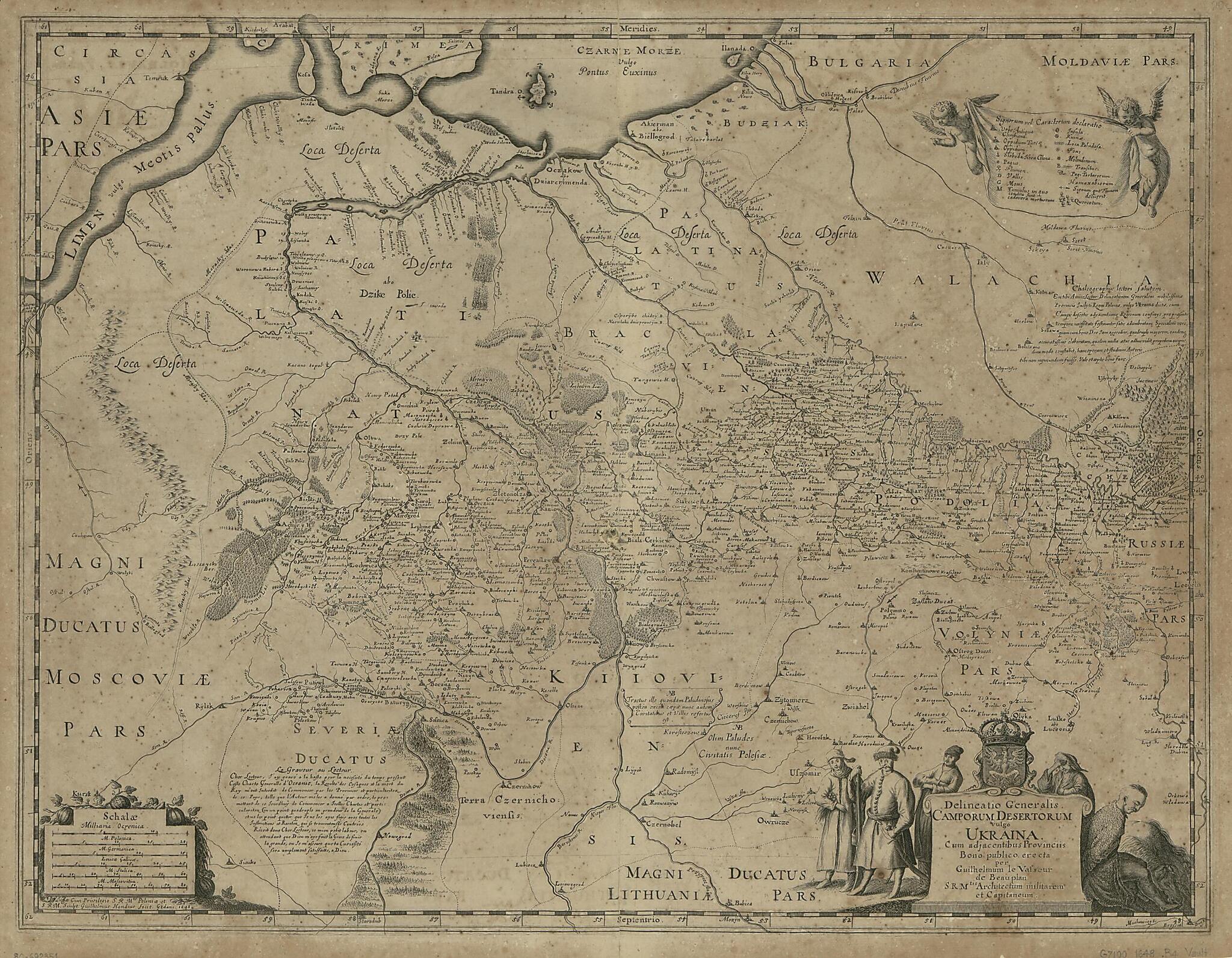
Old map of Ukraine."Guillaume Le Vasseur de Beauplan was a French engineer who worked in Poland between 1630 and 1647. He built fortifications in Ukraine, most of which was then under Polish control, took part in battles with the Cossacks and Tatars, and in 1639 traveled by boat down the Dnieper (Dnipro, in Ukrainian) River. Beauplan produced two important early maps of Ukraine that were based on his own observations and his own careful astronomical and topographic measurements. His map of 1648, shown here, includes detailed information about the border areas, including Tatar routes and forts. The map is oriented with south at the top, a characteristic feature of military maps in countries exposed to attack from the south. The map was engraved by Willem Hondius, the youngest member of the distinguished family of Flemish engravers. In 1651 Beauplan also published, in French, Description d'Ukranie (Description of Ukraine), an important primary source for information about Ukraine in the 17th century." World Digital Library.
Created by Guillaume Le Vasseur Beauplan, Willem Hondius in 1648.
- Includes text in Latin and French and ill.
- Oriented with north to the bottom.
- Relief shown pictorially.
- Scale ca. 1:1,750,000.
Map Subjects
Early Works To 1800
Ukraine
Guillaume Le Vasseur Beauplan
Willem Hondius
1648
- For the best legibility, order your map in the original size or larger. Most maps have intricate detail and small text that is best appreciated when the print size hasn't been reduced.
- Sizes labeled "Fits a Standard Frame" will drop right into any frame that you purchase in that size. The sizes that we offer are commonly available online and at most retail stores.
- Our standard sizes are recommendations based on the aspect ratio of the original map, but still may require some added "white space" in one dimension to fit.
- Non-standard sizes will require custom framing, and we suggest taking your print to the frame shop of your choice after you receive it for the best results.
- Custom sizes are available, simply contact us for a quote.
Below is an approximation of the scale of a few standard sizes, and how they might appear in your space.

