
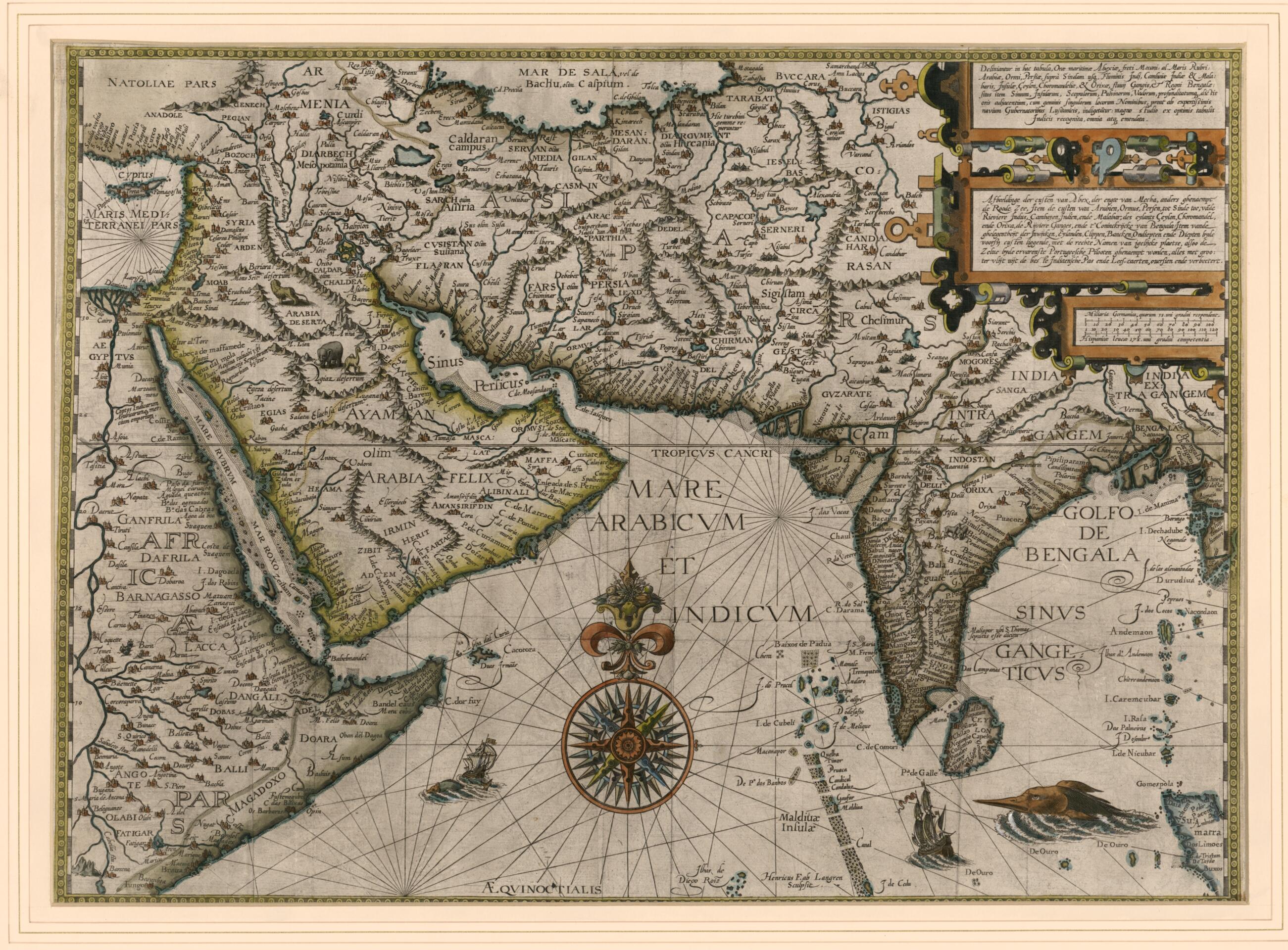
Map Outlining the Maritime Coasts of Arabia Felix, the Meccan Shores, and Also the Red Sea, the Arabian Peninsula, Hormuz, Persia, from Sinda to the Indus River, Khambhat In India and Malabar, the Island of Ceylon, the Coromandel Coast, the Orixa Coas...
- Regular price
-
$77.95 - Regular price
-
$72.95 - Sale price
-
$77.95
Buy one map, get any other map in our collection for 50% OFF! Add to cart to see discount.
Couldn't load pickup availability
About This Map
Discover the timeless beauty of our fine art quality printed reproduction of this antique map. Perfect for history enthusiasts, collectors, and interior decorators.
Restored with meticulous attention to detail by our team with over a decade of experience, this stunning reproduction captures the intricate artistry and historical significance of the original map.
Whether you're a collector or seeking a unique decor piece, this archival-quality map reproduction is a timeless addition to any space. Order now to bring history to life!
Old map of Afghanistan, Bahrain, Bangladesh, Djibouti, Egypt, Eritrea, Ethiopia, India, Iran, Islamic Republic of, Iraq, Israel, Jordan, Kuwait, Lebanon, Pakistan, Qatar, Saudi Arabia, Somalia, Sri Lanka, Syrian Arab Republic, United Arab Emirates, Yemen.1611) was a Dutchman whose contributions to cartography were of great significance in breaking the Portuguese monopoly on trade and navigation in the late 16th century and in opening up southern Asia to the Dutch and later the English. As a young man, van Linschoten spent four years in Spain learning a trade. He then made his way to Lisbon, where he was taken on by the archbishop of Goa, the capital of the "Portuguese State of India." The Portuguese were the only Europeans who knew the safe navigation routes to the East, which they regarded as closely guarded national secrets upon which their wealth depended. Van Linschoten was in Goa in 1583-88, during which time he gained much nautical and mercantile knowledge. On his voyage home he was shipwrecked in the Azores, where he had time to write an account of his travels. He is best known for his magnum opus Itinerario, first published in Amsterdam in 1596, of which this map forms part. The shape of the Arabian Peninsula, including the whole of Arabia, is far more accurate here than on any earlier map. Julfar (present-day Ras al-Khaimah, United Arab Emirates) is indicated for the first time. The arrowhead-shaped Qatar Peninsula, called Catura, is clearly distinguishable, located in the midst of an oyster-bed represented by small pearl-dots. Inscriptions proclaim that the map shows "the location of the gulfs and of the islands, the cliffs, raised earths, shallows, and [their] depths, that are close to these shores, with correct names for the single places, as it is required by the very expert Lusitanian pilots of ships: revised with great accuracy from excellent Indian maps, and corrected throughout." Distance scales are given in Spanish leagues and German miles.
Created by Henricus F. Ab (Henricus Florentius) Langren, Jan Huygen Van Linschoten in 1596.
- Title devised, in English, by Library staff.
- Original resource extent: 1 map : hand colored ; 38 x 54 centimeters.
- Reference extracted from World Digital Library: Utrecht University Library, "Key to the East: Jan Huygen van Linschoten's 'Itinerario'," http://bc.library.uu.nl/key-east-jan-huygen-van-linschoten-s-itinerario.html. External
- Original resource at: Qatar National Library.
- Content in Latin and Dutch.
- Description based on data extracted from World Digital Library, which may be extracted from partner institutions.
- For the best legibility, order your map in the original size or larger. Most maps have intricate detail and small text that is best appreciated when the print size hasn't been reduced.
- Sizes labeled "Fits a Standard Frame" will drop right into any frame that you purchase in that size. The sizes that we offer are commonly available online and at most retail stores.
- Our standard sizes are recommendations based on the aspect ratio of the original map, but still may require some added "white space" in one dimension to fit.
- Non-standard sizes will require custom framing, and we suggest taking your print to the frame shop of your choice after you receive it for the best results.
- Custom sizes are available, simply contact us for a quote.
Below is an approximation of the scale of a few standard sizes, and how they might appear in your space.

