
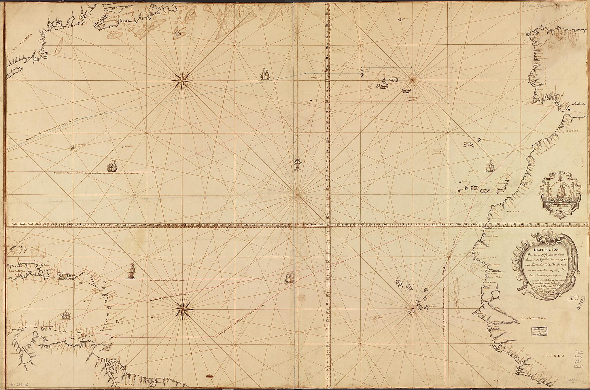
Descripción O Carta De Golfo Que Contiene La Costa De España, Verueria Y Guinea Hasta Las Yslas De Barlovto. Con Sus Derrotas De Y Da Y Buelta Adistintos Parages 1756
- Regular price
-
$98.95 - Regular price
-
$93.95 - Sale price
-
$98.95
Buy one map, get any other map in our collection for 50% OFF! Add to cart to see discount.
Couldn't load pickup availability
About This Map
Discover the timeless beauty of our fine art quality printed reproduction of this antique map. Perfect for history enthusiasts, collectors, and interior decorators.
Restored with meticulous attention to detail by our team with over a decade of experience, this stunning reproduction captures the intricate artistry and historical significance of the original map.
Whether you're a collector or seeking a unique decor piece, this archival-quality map reproduction is a timeless addition to any space. Order now to bring history to life!
Old map of North Atlantic Ocean.Created by Jph Blanco, Gabriel Muñoz, Spain) Real Escuela De Navegación (Cádiz in 1756.
- Also shows routes of expeditions.
- Prime meridian: Tenerife.
- Watermark: PVL [Pieter van Ley] in 1 character.
- Pen-and-ink and watercolor.
- Mounted on cloth backing.
- Printed label describing the map mounted on verso.
- Annotated in black ink in lower right corner: N. 1o [indecipherable].
- Order number annotated in pencil in lower right corner: 367902/27.
- Noteworthy acc. 1927-28, no. 107
Map Subjects
Discovery And Exploration
Early Works To 1800
Manuscript Maps
Maps Manuscript
North Atlantic Ocean
Jph Blanco
Gabriel Muñoz
Spain) Real Escuela De Navegación (Cádiz
1756
- For the best legibility, order your map in the original size or larger. Most maps have intricate detail and small text that is best appreciated when the print size hasn't been reduced.
- Sizes labeled "Fits a Standard Frame" will drop right into any frame that you purchase in that size. The sizes that we offer are commonly available online and at most retail stores.
- Our standard sizes are recommendations based on the aspect ratio of the original map, but still may require some added "white space" in one dimension to fit.
- Non-standard sizes will require custom framing, and we suggest taking your print to the frame shop of your choice after you receive it for the best results.
- Custom sizes are available, simply contact us for a quote.
Below is an approximation of the scale of a few standard sizes, and how they might appear in your space.
