
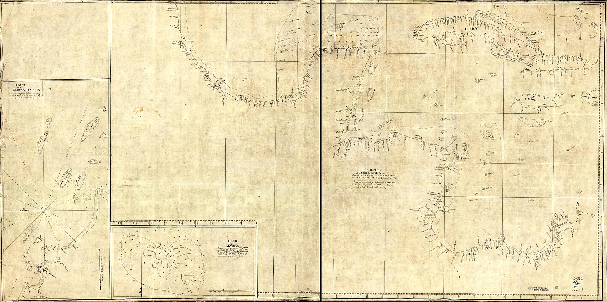
Descripcion De La Costa De Tierra Firme Desde El Cavo De La Agusa Hasta La Barra De Palmas Diga De La Trinidad: Con Todas Las Yslas, Bajos, Arresifes & Ca. Leho Por Las Latitudes Y Longitudes De Dn. Bartolome De La Rosa in 1757
- Regular price
-
$108.95 - Regular price
-
$103.95 - Sale price
-
$108.95
Buy one map, get any other map in our collection for 50% OFF! Add to cart to see discount.
Couldn't load pickup availability
About This Map
Discover the timeless beauty of our fine art quality printed reproduction of this antique map. Perfect for history enthusiasts, collectors, and interior decorators.
Restored with meticulous attention to detail by our team with over a decade of experience, this stunning reproduction captures the intricate artistry and historical significance of the original map.
Whether you're a collector or seeking a unique decor piece, this archival-quality map reproduction is a timeless addition to any space. Order now to bring history to life!
Old early map / manuscript map of Caribbean Area, Llave, Mexico, Vera Cruz Region, Veracruz, Llave, West Indies.Created by Balentin Cierto, Felis Rodríguez in 1757.
- Scale ca. 1:3,500,000.
- Title on verso: Palmas to Carthagena, 206.
- Manuscript, pen-and-ink, on tracing paper.
- Prime meridian: Ferro.
- Depths shown by soundings.
- Insets: Plans de la Nueva Vera Cruz; con todos sus bajos, yslas, y sondas situado in los 19⁰10ʹ de latd. Norte y en 277⁰5ʹ de longt. segun el meridiano de Tenerife [ca. 1:110,000]--Plano del Alacran cituado en la sonda de Campeche por los 22⁰30ʹ de latd. no. Leva[n]tado por el Capt. Dn. Felis Rodriguez. En termino de dos meses que estubo endho bajo examinado con todo cuydado [ca. 1:150,000]
- On verso: 63.
Map Subjects
Caribbean Area
Coasts
Early Maps
Early Works To 1800
Manuscript Maps
Maps Manuscript
Mexico
Vera Cruz Region
Llave Mexico)
Llave
West Indies
Veracruz
Early Maps
Manuscript Maps
Balentin Cierto
Felis Rodríguez
1757
- For the best legibility, order your map in the original size or larger. Most maps have intricate detail and small text that is best appreciated when the print size hasn't been reduced.
- Sizes labeled "Fits a Standard Frame" will drop right into any frame that you purchase in that size. The sizes that we offer are commonly available online and at most retail stores.
- Our standard sizes are recommendations based on the aspect ratio of the original map, but still may require some added "white space" in one dimension to fit.
- Non-standard sizes will require custom framing, and we suggest taking your print to the frame shop of your choice after you receive it for the best results.
- Custom sizes are available, simply contact us for a quote.
Below is an approximation of the scale of a few standard sizes, and how they might appear in your space.
