
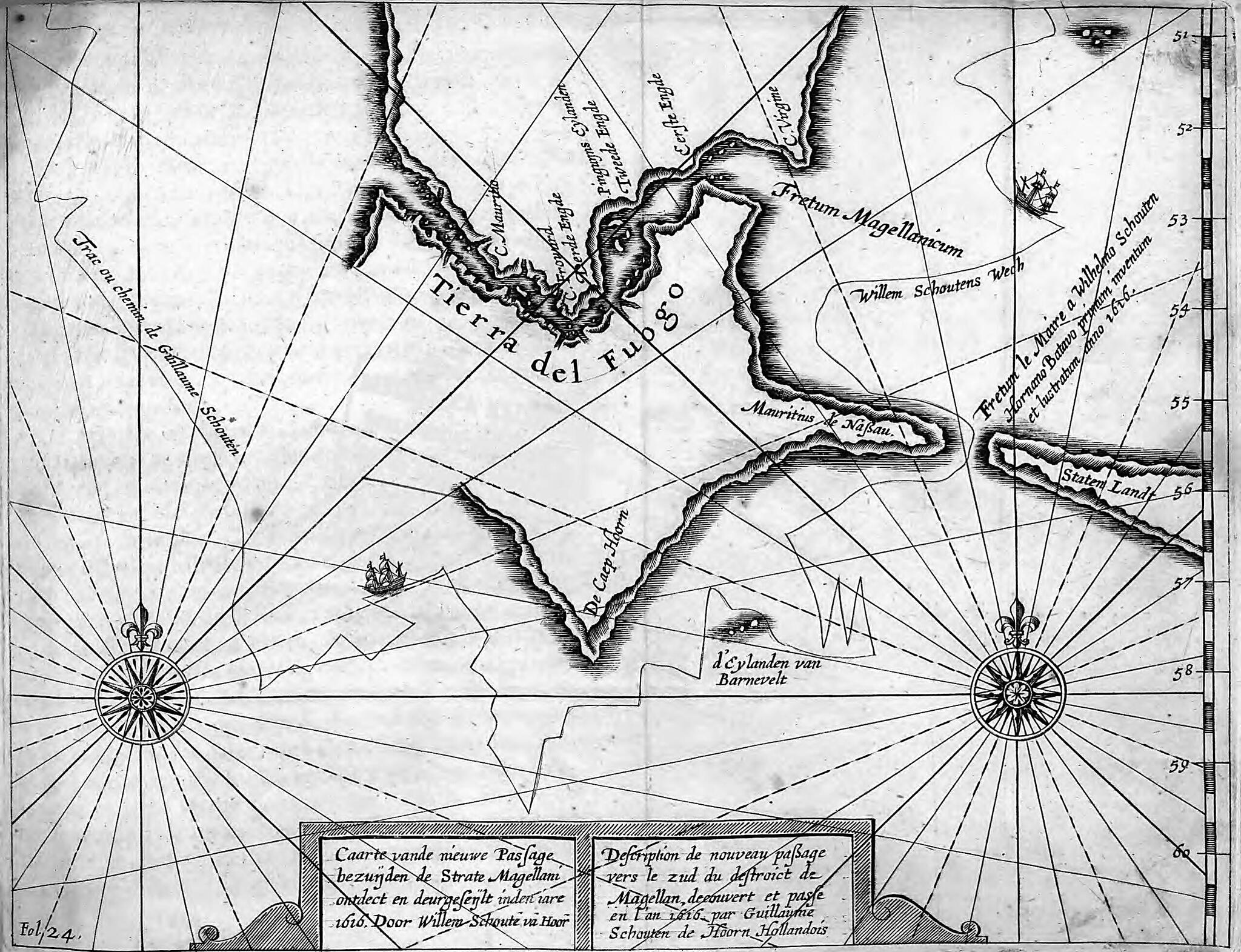
Description of the New Route to the South of the Strait of Magellan Discovered and Set In the Year 1616 by Dutchman Willem Schouten De Hoorn. (Coarte Vanda Niewe Passage Bezunden De Strate Magellani Ontdet En Deurgesenlt Inden Iare 1616 Door Willem Sc...
- Regular price
-
$49.95 - Regular price
-
$34.95 - Sale price
-
$49.95
Buy one map, get any other map in our collection for 50% OFF! Add to cart to see discount.
Couldn't load pickup availability
About This Map
Discover the timeless beauty of our fine art quality printed reproduction of this antique map. Perfect for history enthusiasts, collectors, and interior decorators.
Restored with meticulous attention to detail by our team with over a decade of experience, this stunning reproduction captures the intricate artistry and historical significance of the original map.
Whether you're a collector or seeking a unique decor piece, this archival-quality map reproduction is a timeless addition to any space. Order now to bring history to life!
Old map of Argentina, Chile.-1616) and Willem Corneliszoon Schouten (circa 1567--1625) set out in two ships, the Eendracht and the Hoorn, from the Dutch port of Texel. Their goal was to find a new route to the Moluccas Islands, Europe's main source of pepper in the lucrative spice trade with the East Indies, and in so doing avoid the trade monopoly of the Dutch East Indies Company. They sailed south of the Strait of Magellan and on January 24, 1616, discovered a new passage between the Atlantic and Pacific oceans: a strait about 13 kilometers wide between Tierra del Fuego and what they called Staten Land (present-day Isla de los Estados, Argentina). The passage came to be called Le Maire Strait. Several days later, Le Maire and Schouten became the first Europeans to round the extreme southern point of South America, known for its storms and heavy seas, which they named Cape Horn in honor of Schouten's birthplace, the city of Hoorn. This map of Le Maire Strait is from the French edition of Schouten's journal of the voyage, Journal ou description du merveillevx voyage de Guillaume Schovten, hollandois natif de Hoorn, fait en années 1615, 1616 & 1617 (Journal or description of the marvelous voyage of Willem Schouten, a Dutch native of Hoorn, made in the years 1615, 1616, and 1617), which was published in Amsterdam in 1619.
Created by Jacob Le Maire, Willem Corneliszoon Schouten in 1619.
- Title devised, in English, by Library staff.
- "From Journal ou description du merveillevx voyage de Guillaume Schovter, hollandois natif de hoorn, fait es années 1615, 1616 y 1617 : comme (encircum-navegeant le globe terrestre) il a descourvet vers le Zud du Detroit de Magellan ... Amsterdam : Harman Lanfon, 1619. Page 88."--Note extracted from World Digital Library.
- Original resource extent: 1 map.
- Original resource at: National Library of Chile.
- Content in French and Dutch.
- Description based on data extracted from World Digital Library, which may be extracted from partner institutions.
Map Subjects
1616 To 1619
Argentina
Chile
Exploration And Encounters
Horn Cape (Chile)
Le Maire Strait (Argentina)
Magellan Strait Of (Chile And Argentina)
Tierra Del Fuego (Argentina And Chile)
Jacob Le Maire
Willem Corneliszoon Schouten
1619
- For the best legibility, order your map in the original size or larger. Most maps have intricate detail and small text that is best appreciated when the print size hasn't been reduced.
- Sizes labeled "Fits a Standard Frame" will drop right into any frame that you purchase in that size. The sizes that we offer are commonly available online and at most retail stores.
- Our standard sizes are recommendations based on the aspect ratio of the original map, but still may require some added "white space" in one dimension to fit.
- Non-standard sizes will require custom framing, and we suggest taking your print to the frame shop of your choice after you receive it for the best results.
- Custom sizes are available, simply contact us for a quote.
Below is an approximation of the scale of a few standard sizes, and how they might appear in your space.

