
Drawn Maps and Plans of Recife In Pernambuco, All Saints' Bay, and the Coast from Bahia to Gãmam.... (Desenho E Plantas Iluminadas Do Recife De Pernambuco, Da Bahia De Todos Os Stos., Da Costa Do Mâr E Barra Da Bahia Athé a Do Gãmam) 1631
- Regular price
-
$66.95 - Regular price
-
$61.95 - Sale price
-
$66.95
Buy one map, get any other map in our collection for 50% OFF! Add to cart to see discount.
Couldn't load pickup availability
About This Map
Discover the timeless beauty of our fine art quality printed reproduction of this antique map. Perfect for history enthusiasts, collectors, and interior decorators.
Restored with meticulous attention to detail by our team with over a decade of experience, this stunning reproduction captures the intricate artistry and historical significance of the original map.
Whether you're a collector or seeking a unique decor piece, this archival-quality map reproduction is a timeless addition to any space. Order now to bring history to life!
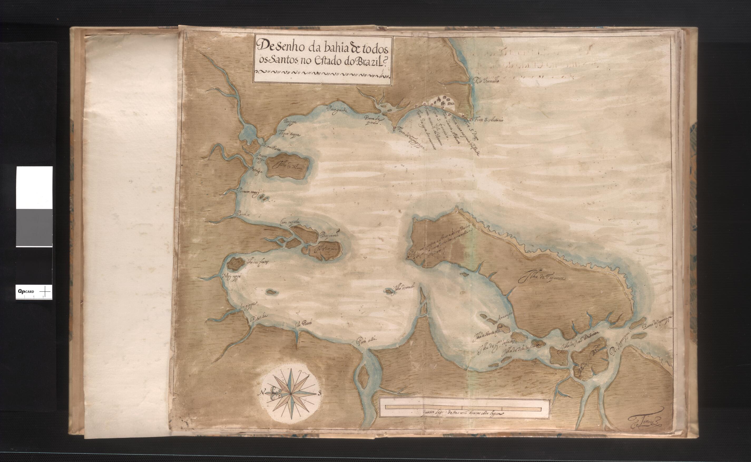
Old map of Bahia, Brazil, Pernambuco.leaved, hand-drawn atlas shows the coastal area of Brazil's Pernambuco and Bahia states as they appeared in the early 1630s. The maps include details of the city of Recife and All Saints' Bay, as well as details of the coastline. The area was first settled by the Portuguese in 1534, and Pernambuco was one of Portugal's only profitable Brazilian colonies during the early colonial period. The area benefitted from successful cotton and sugar cultivation. Pernambuco came under Dutch rule in 1630, around the time these maps were drawn, and remained a Dutch holding until 1654. The Dutch West India Company exported thousands of tons of Pernambuco sugar to the Netherlands. The maps are believed to be the work of Pedro Nunes Tinoco (?-1641), a Portuguese architect known primarily for his work on several major churches in Lisbon.
Created by Pedro Nunes Tinoco in 1631.
- Title devised, in English, by Library staff.
- Original resource extent: 1 watercolor and pen-and ink manuscript atlas (6 leaves) ; 44 x 35 centimeters.
- Original resource at: National Library of Brazil.
- Content in Portuguese.
- Description based on data extracted from World Digital Library, which may be extracted from partner institutions.
- For the best legibility, order your map in the original size or larger. Most maps have intricate detail and small text that is best appreciated when the print size hasn't been reduced.
- Sizes labeled "Fits a Standard Frame" will drop right into any frame that you purchase in that size. The sizes that we offer are commonly available online and at most retail stores.
- Our standard sizes are recommendations based on the aspect ratio of the original map, but still may require some added "white space" in one dimension to fit.
- Non-standard sizes will require custom framing, and we suggest taking your print to the frame shop of your choice after you receive it for the best results.
- Custom sizes are available, simply contact us for a quote.
Below is an approximation of the scale of a few standard sizes, and how they might appear in your space.
