
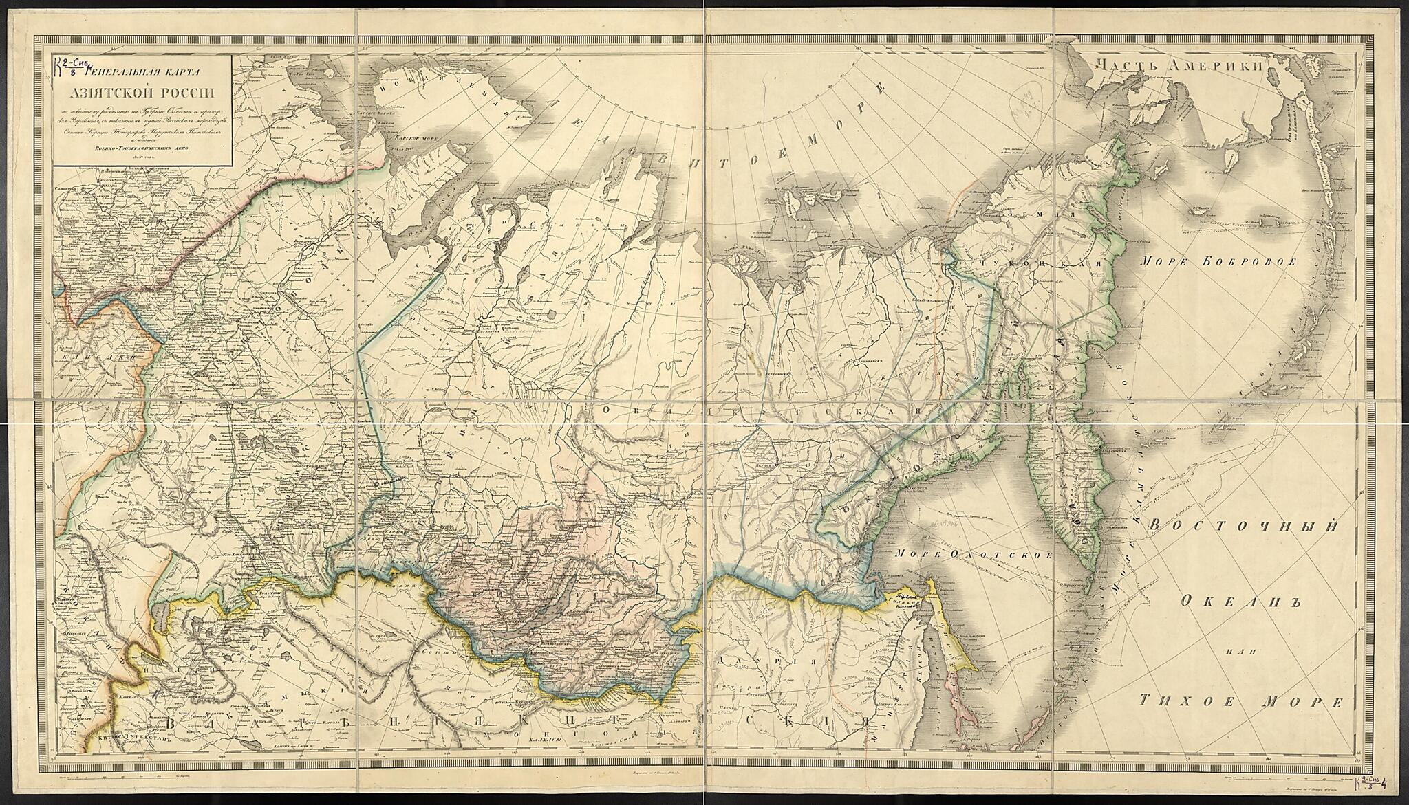
General'nai︠a︡ Karta Aziatskoĭ Rossii Po Noveĭshemu Razdelenii︠u︡ Na Gubernii, Oblasti I Primorskie Upravlenii︠a︡, S Ukazaniem Puteĭ Rossiĭskikh Morekhodov. (Генеральная карта Азиатской России по нов...
- Regular price
-
$125.95 - Regular price
-
$120.95 - Sale price
-
$125.95
Buy one map, get any other map in our collection for 50% OFF! Add to cart to see discount.
Couldn't load pickup availability
About This Map
Discover the timeless beauty of our fine art quality printed reproduction of this antique map. Perfect for history enthusiasts, collectors, and interior decorators.
Restored with meticulous attention to detail by our team with over a decade of experience, this stunning reproduction captures the intricate artistry and historical significance of the original map.
Whether you're a collector or seeking a unique decor piece, this archival-quality map reproduction is a timeless addition to any space. Order now to bring history to life!
Old map of Buryatia, Irkutsk Oblast, Krasnoyarsk Krai, Nenetskiy Autonomous Okrug, Novosibirsk Oblast, Omsk Oblast, Republic, Republic of, Russian Federation, Sakha, Tomsk Oblast, Tyumen Oblast, Yakutiya, Yamalo.-Bering, Billings, Kruzenshtern, Golovin, Sarychev, Gall--on their expeditions to the North Pacific and Alaska. The map was produced by the Corps of Military Topographers which, under a government regulation of 1822, was attached to the General Staff and the Military Topographical Depot "to the end that they might the more successfully carry out state surveys in peacetime and reconnaissance of localities in the rear of the Army in time of war." In Russia as in other European countries (and the United States), in the 19th century responsibility for mapping national territory often was assigned to the military. World Digital Library.
- Karta Aziatskoĭ Rossii ot Ural'skikh gor do Tikhookeanskogo poberezh'i︠a︡. Pokazany: granit︠s︡y okrugov, oblasteĭ i uezdov, naselennye punkty (6gr.), dorogi (2 gr.), kreposti, reduty, forposty, karauly, zavody, rudniki, razvaliny; naseli︠a︡i︠u︡shchie narodnosti nadpisi︠a︡mi, marshruty plavaniĭ: Beringa, Bilingsa, Kruzenshterna, Golovina, Sarycheva, Galla; rel'ef shtrikhami.
- Original map at: National Library of Russia
- Карта Азиатской России от Уральских гор до Тихоокеанского побережья. Показаны: границы округов, областей и уездов, населенные пункты (6гр.), дороги (2 гр.), крепости, редуты, форпосты, караулы, заводы, рудники, развалины; населяющие народности надписями, маршруты плаваний: Беринга, Билингса, Крузенштерна, Головина, Сарычева, Галла; рельеф штрихами.
Map Subjects
Buryatia Republic Of
Ethnology
Explorers
Irkutsk Oblast
Krasnoyarsk Krai
Novosibirsk Oblast
Omsk Oblast
Russian Federation
Sakha (Yakutiya) Republic
Siberia
Tomsk Oblast
Tyumen Oblast
Voyages And Travels
Nenetskiy Autonomous Okrug
Buryatia
Republic
Republic Of
Sakha
Yakutiya
Yamalo
1844
- For the best legibility, order your map in the original size or larger. Most maps have intricate detail and small text that is best appreciated when the print size hasn't been reduced.
- Sizes labeled "Fits a Standard Frame" will drop right into any frame that you purchase in that size. The sizes that we offer are commonly available online and at most retail stores.
- Our standard sizes are recommendations based on the aspect ratio of the original map, but still may require some added "white space" in one dimension to fit.
- Non-standard sizes will require custom framing, and we suggest taking your print to the frame shop of your choice after you receive it for the best results.
- Custom sizes are available, simply contact us for a quote.
Below is an approximation of the scale of a few standard sizes, and how they might appear in your space.
