
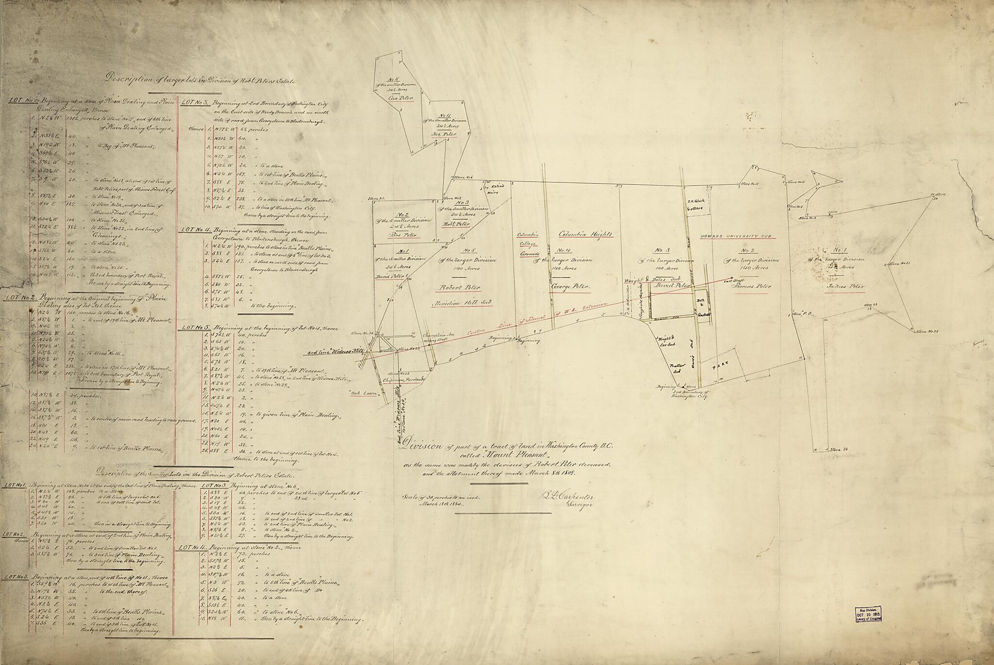
Division of Part of a Tract of Land In Washington County D.C. Called Mount Pleasant : As the Same Was Made by the Devisees of Robert Peter Deceased, and the Allotment Thereof Made March 8th 1809
- Regular price
-
$111.95 - Regular price
-
$106.95 - Sale price
-
$111.95
Buy one map, get any other map in our collection for 50% OFF! Add to cart to see discount.
Couldn't load pickup availability
About This Map
Discover the timeless beauty of our fine art quality printed reproduction of this antique map. Perfect for history enthusiasts, collectors, and interior decorators.
Restored with meticulous attention to detail by our team with over a decade of experience, this stunning reproduction captures the intricate artistry and historical significance of the original map.
Whether you're a collector or seeking a unique decor piece, this archival-quality map reproduction is a timeless addition to any space. Order now to bring history to life!
Old map of Columbia Heights, District of Columbia, Maryland, Mount Pleasant, United States, Washington, Washington Aqueduct, Washington Aqueduct (Md.), Washington Aqueduct (Washington), Washington D.C..Created by B. D. (Benjamin D.) Carpenter in 1809.
- Cadastral survey map showing landowners' names and "Centre line of tunnel of W.A. extension."
- Also covers Meridian Hill, Columbia Heights, Howard University, and adjacent tracts.
- "March 18th 1884."
- Black ink, red ink, and yellow wash.
- Soiled, torn, fold-lined, and taped.
- Includes statistical tables titled "Description of larger lots in Division of Rob't Peters Estate."
- On verso in ink: Mt. Pleasant, Peter Subd'n.
- Phillips. Washington 635
Map Subjects
Columbia Heights (Washington D.C.)
District Of Columbia
Homes And Haunts
Howard University
Maps Manuscript
Maryland
Mount Pleasant
Mount Pleasant (Washington D.C.)
Peter Robert
Real Property
Surveys
United States
Washington
Washington (D.C.)
Washington Aqueduct (Md. And Washington D.C.)
Washington Aqueduct (Md.)
Washington Aqueduct (Washington)
Columbia Heights
Washington Aqueduct
Washington D.C.
B. D. (Benjamin D.) Carpenter
1809
- For the best legibility, order your map in the original size or larger. Most maps have intricate detail and small text that is best appreciated when the print size hasn't been reduced.
- Sizes labeled "Fits a Standard Frame" will drop right into any frame that you purchase in that size. The sizes that we offer are commonly available online and at most retail stores.
- Our standard sizes are recommendations based on the aspect ratio of the original map, but still may require some added "white space" in one dimension to fit.
- Non-standard sizes will require custom framing, and we suggest taking your print to the frame shop of your choice after you receive it for the best results.
- Custom sizes are available, simply contact us for a quote.
Below is an approximation of the scale of a few standard sizes, and how they might appear in your space.
