
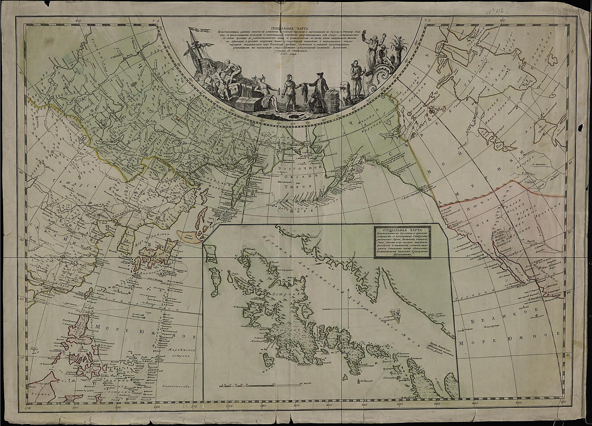
General'nai︠a︡ Karta, Predstavli︠a︡i︠u︡shchai︠a︡ Udobnye Sposoby K Umnozhenii︠u︡ Rossiĭskoĭ Torgovli I Moreplavanii︠u︡ Po Tikhomu I I︠U︡zhnomu Okeanu. (Генеральная карта, представляющая уд�...
- Regular price
-
$91.95 - Regular price
-
$86.95 - Sale price
-
$91.95
Buy one map, get any other map in our collection for 50% OFF! Add to cart to see discount.
Couldn't load pickup availability
About This Map
Discover the timeless beauty of our fine art quality printed reproduction of this antique map. Perfect for history enthusiasts, collectors, and interior decorators.
Restored with meticulous attention to detail by our team with over a decade of experience, this stunning reproduction captures the intricate artistry and historical significance of the original map.
Whether you're a collector or seeking a unique decor piece, this archival-quality map reproduction is a timeless addition to any space. Order now to bring history to life!
Old map of Alaska, United States.American Company active in the maritime fur trade in sea otter pelts in the North Pacific from the mid-18th century to the mid-19th century. The map displays, for the era in which it was made, a thoroughgoing level of knowledge of Alaska. It clearly incorporates cartographic insights gained from both the recent Russian explorations in the North Pacific since the voyage of Vitus Bering to Alaska in 1741 as well as the subsequent trading expeditions of the Russian-American Company along the Aleutian Islands and south-central Alaska. The coverage of the map is uneven, however, as reflected in the blank spaces for much of interior Canada and the North American Arctic as well as the northern reaches of Australasia and other parts of the Southern Pacific region. It shows the full length of the Great Wall of China and highlights relief where known as well as gives the names of islands, rivers, lakes, and other bodies of water. Siberia and Alaska are shown with the most cartographic detail, which of course reflects the intimate knowledge of these regions gained by the Russian-American Company. These features also would have been the most novel and valuable parts of this map for foreign interests. The map includes a detailed inset of Kodiak Island, where the Russian-American Company then had its headquarters, and adjoining regions of Alaska. In contrast to the main part of the map, which has north oriented towards the top, the inset shows west oriented towards the top and thus presents Kodiak at an unusual angle. The inset has a scale listed in versts, a tsarist-era unit of distance equal to 1.07 kilometers. No scale is provided for the main map. World Digital Library.
Created by Ivan Ivanovich Golikov in 1787.
- Odna iz interesneĭshikh kart, kotorai︠a︡ svidetel'stvuet ob otkrytii︠a︡kh russkikh issledovateleĭ na Severo-Zapadnom poberezh'e Ameriki i v Tikhom okeane. Ee sostavili kapitan Golikov i kupet︠s︡ Shelikhov Grigoriĭ, kotorogo za neutomimui︠u︡ dei︠a︡tel'nost' na blago Rossii G.R. Derzhavin nazval "Kolumbom Rossiĭskim".
- Original map at: Russian State Library
- Одна из интереснейших карт, которая свидетельствует об открытиях русских исследователей на Северо-Западном побережье Америки и в Тихом океане. Ее составили капитан Голиков и купец Шелихов Григорий, которого за неутомимую деятельность на благо России Г.Р. Державин назвал "Колумбом Российским".
Map Subjects
Alaska
East Asia
American Company
United States Of America
United States
Ivan Ivanovich Golikov
1787
- For the best legibility, order your map in the original size or larger. Most maps have intricate detail and small text that is best appreciated when the print size hasn't been reduced.
- Sizes labeled "Fits a Standard Frame" will drop right into any frame that you purchase in that size. The sizes that we offer are commonly available online and at most retail stores.
- Our standard sizes are recommendations based on the aspect ratio of the original map, but still may require some added "white space" in one dimension to fit.
- Non-standard sizes will require custom framing, and we suggest taking your print to the frame shop of your choice after you receive it for the best results.
- Custom sizes are available, simply contact us for a quote.
Below is an approximation of the scale of a few standard sizes, and how they might appear in your space.

