
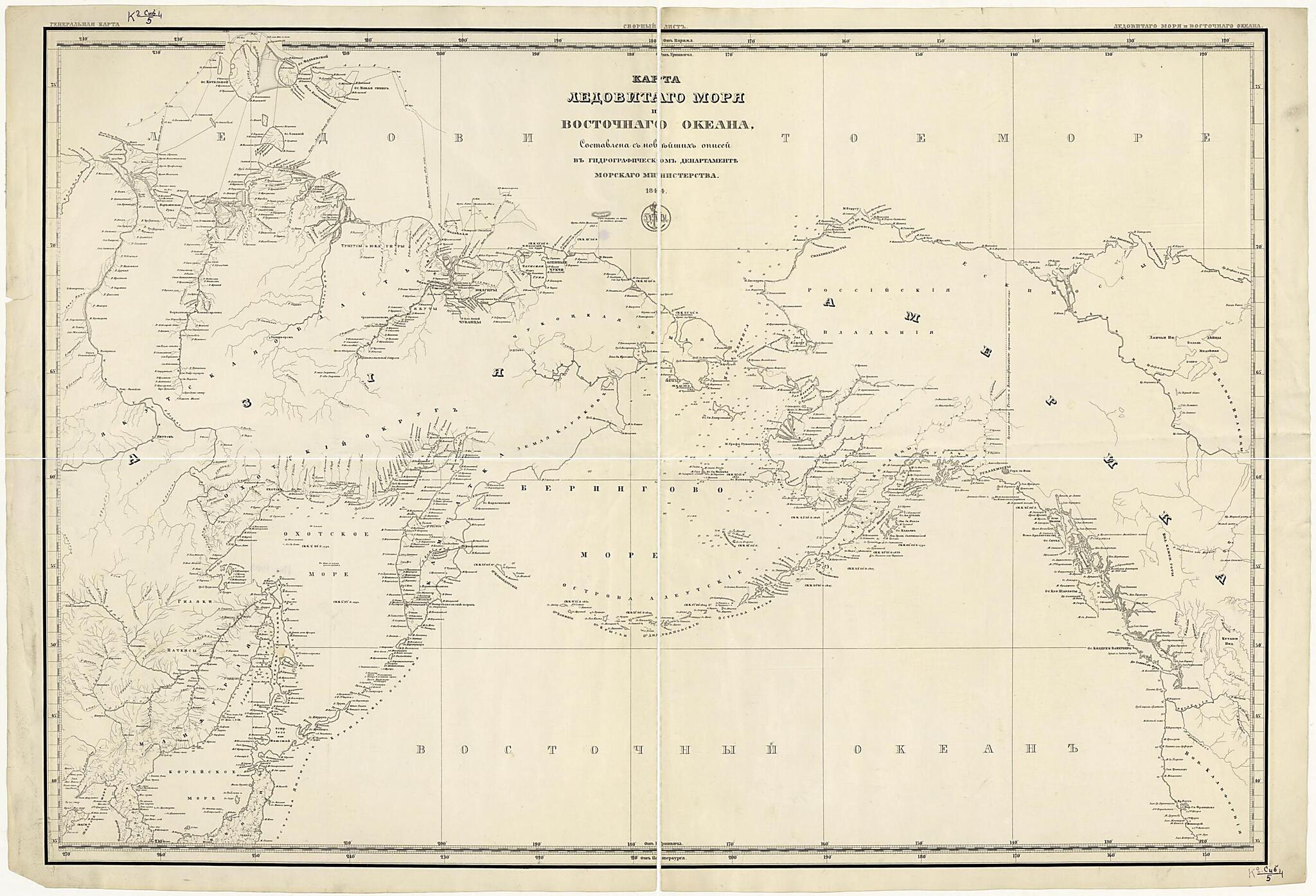
Karta Ledovitago Mori︠a︡ I Vostochnago Okeana, Sostavlena S Noveĭshikh Opiseĭ V Gidrograficheskom Departamente Morskago Ministerstva. (Карта Ледовитаго моря и Восточнаго океана, составлена с нов�...
- Regular price
-
$103.95 - Regular price
-
$98.95 - Sale price
-
$103.95
Buy one map, get any other map in our collection for 50% OFF! Add to cart to see discount.
Couldn't load pickup availability
About This Map
Discover the timeless beauty of our fine art quality printed reproduction of this antique map. Perfect for history enthusiasts, collectors, and interior decorators.
Restored with meticulous attention to detail by our team with over a decade of experience, this stunning reproduction captures the intricate artistry and historical significance of the original map.
Whether you're a collector or seeking a unique decor piece, this archival-quality map reproduction is a timeless addition to any space. Order now to bring history to life!
Old map of Russian Federation.Created by Gidrograficheskiĭ Departament Morskogo Ministerstva in 1844.
- Cherno-belai︠a︡. Kartograficheskai︠a︡ setka na vodnoĭ chasti: po dolgote cherez 20° s vykhodom koordinat cherez 10°, po shirote cherez 20° s vykhodom koordinat cherez 5°; schet dolgot ot Grinvicha, Parizha, Sankt-Peterburga.
- Pokazany: chasti Azii i Sev.Ameriki, granit︠s︡a vladeniĭ Rossii i Velikobritanii v Sev. Amerike (po traktatu 1825g.), oblasti i okruga v Aziatskoĭ Rossii nadpisi︠a︡mi, naselennye punkty (2 gradat︠s︡ii), rasselenie narodov nadpisi︠a︡mi; marshruty plavaniĭ rossiĭskikh mor.
- Original map at: National Library of Russia
- Черно-белая. Картографическая сетка на водной части: по долготе через 20° с выходом координат через 10°, по широте через 20° с выходом координат через 5°; счет долгот от Гринвича, Парижа, Санкт-Петербурга.
- Показаны: части Азии и Сев.Америки, граница владений России и Великобритании в Сев. Америке (по трактату 1825г.), области и округа в Азиатской России надписями, населенные пункты (2 градации), расселение народов надписями; маршруты плаваний российских мор.
Map Subjects
Ethnography
Russian Federation
Siberia
Gidrograficheskiĭ Departament Morskogo Ministerstva
1844
- For the best legibility, order your map in the original size or larger. Most maps have intricate detail and small text that is best appreciated when the print size hasn't been reduced.
- Sizes labeled "Fits a Standard Frame" will drop right into any frame that you purchase in that size. The sizes that we offer are commonly available online and at most retail stores.
- Our standard sizes are recommendations based on the aspect ratio of the original map, but still may require some added "white space" in one dimension to fit.
- Non-standard sizes will require custom framing, and we suggest taking your print to the frame shop of your choice after you receive it for the best results.
- Custom sizes are available, simply contact us for a quote.
Below is an approximation of the scale of a few standard sizes, and how they might appear in your space.
