
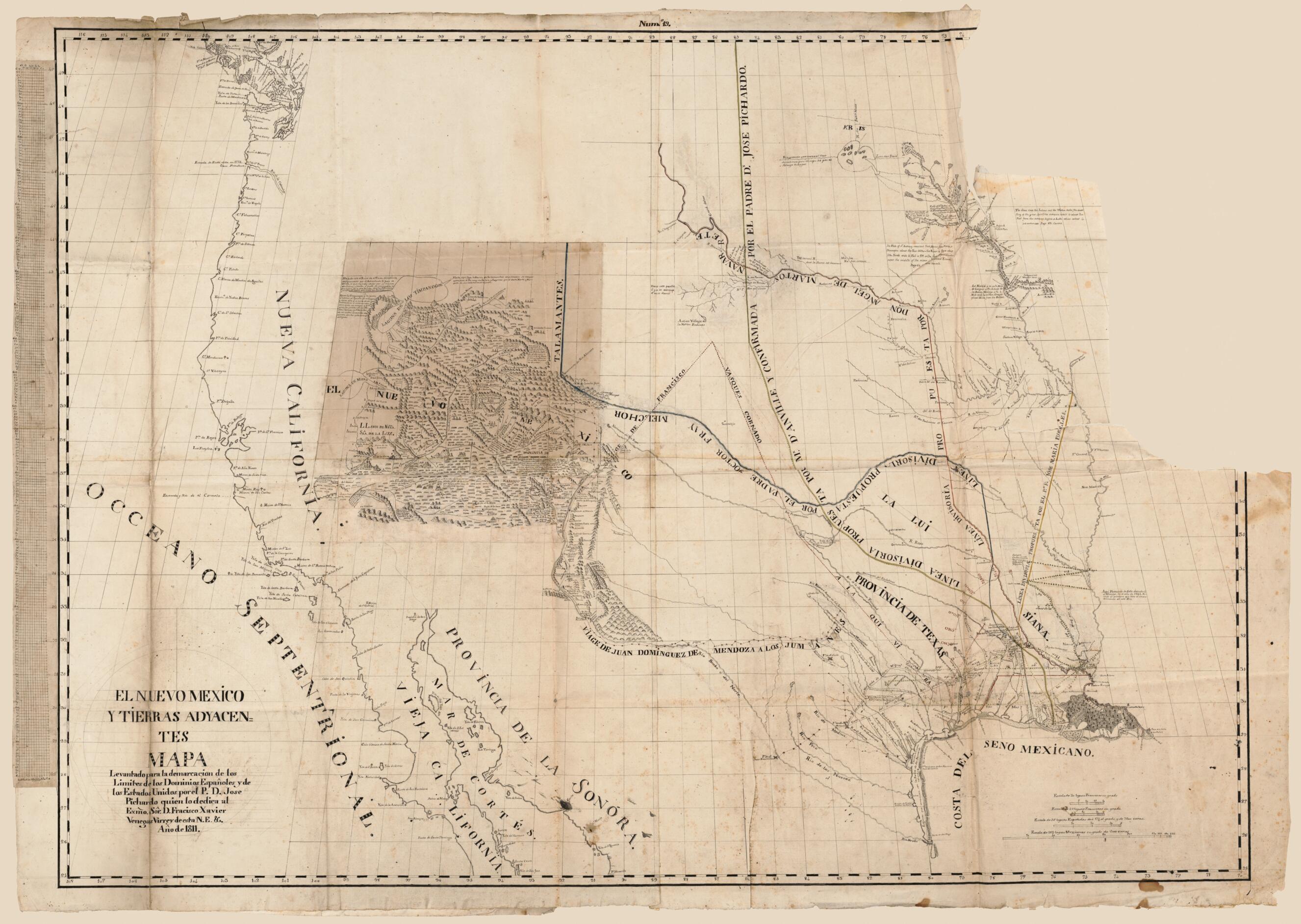
El Nuevo Mexico Y Tierras Adyacentes Mapa Levantado Para La Demarcacion De Los Limites De Los Dominios Españoles Y De Los Estados Unidos Por El P.D. Jose Pichardo Quien Lo Dedica Al Exmo. Sor. D. Fracisco Xavier Venegas Virrey De Esta N.E. &. Año De...
- Regular price
-
$210.95 - Regular price
-
$205.95 - Sale price
-
$210.95
Buy one map, get any other map in our collection for 50% OFF! Add to cart to see discount.
Couldn't load pickup availability
About This Map
Discover the timeless beauty of our fine art quality printed reproduction of this antique map. Perfect for history enthusiasts, collectors, and interior decorators.
Restored with meticulous attention to detail by our team with over a decade of experience, this stunning reproduction captures the intricate artistry and historical significance of the original map.
Whether you're a collector or seeking a unique decor piece, this archival-quality map reproduction is a timeless addition to any space. Order now to bring history to life!
Old manuscript map of Louisiana, Louisiana Purchase, Texas, United States, West.Created by José Antonio Pichardo in 1811.
- Relief shown pictorially and by hachures.
- Spanish manuscript map of Spanish Texas, Louisiana Territory and the Trans-Mississippi West, prepared for the use by the Spanish Crown in defending its claims to Spanish Texas against the United States' post-Louisiana Purchase of the lands between the Mississippi River and the Rio Grande.
- Shows four proposed boundary lines, in red and in another color of ink, between New Spain and the United States, drawn by Pichardo, Spanish place names and features, settlements, missions, names of explorers and tracks of their routes.
- This map has some imperfections: missing upper right portion of sheet and some torn at fold lines. We'll do our best to restore the image before printing.
- Manuscript map encapsulated in clear plastic.
- Accompanied by facsimile of a different version of the map. 80 x 114 cm.
- Includes descriptive notes.
- For the best legibility, order your map in the original size or larger. Most maps have intricate detail and small text that is best appreciated when the print size hasn't been reduced.
- Sizes labeled "Fits a Standard Frame" will drop right into any frame that you purchase in that size. The sizes that we offer are commonly available online and at most retail stores.
- Our standard sizes are recommendations based on the aspect ratio of the original map, but still may require some added "white space" in one dimension to fit.
- Non-standard sizes will require custom framing, and we suggest taking your print to the frame shop of your choice after you receive it for the best results.
- Custom sizes are available, simply contact us for a quote.
Below is an approximation of the scale of a few standard sizes, and how they might appear in your space.

